
Part One: Spatial Strategy and Policies (Regulation 18)
5. Dudley Borough Spatial Strategy
5.1 The Dudley Local Plan (DLP) can help achieve sustainable development by ensuring that the borough benefits from the right development in the right place at the right time. This development will meet the needs of people living and working in the borough, whilst protecting and enhancing the environment and its unique character.
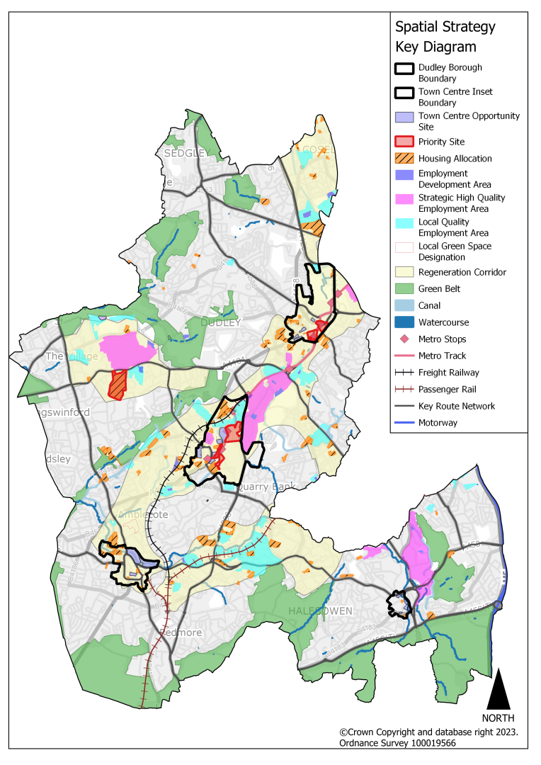
5.2 The Spatial Strategy as set out in policies DLP1, DLP2 and DLP3, and illustrated on the Key Diagram (Figure 5.1) provides the overarching basis for the Plan's proposals for growth and infrastructure improvements. This diagram is supplemented by thematic key diagrams for housing, economy, transport, environment, waste and minerals. These policies address all the Strategic Priorities.
Spatial Strategy Plan: Dudley Borough
Development Strategy
5.3 Policy DLP1 provides the overarching development strategy for the Dudley Borough, setting out the scale and distribution of new development for the Plan period to 2041.
(62) Policy DLP1 Development Strategy
- To deliver sustainable economic and housing growth and to meet strategic planning targets based on the needs of local communities and businesses, this plan will:
- Deliver at least 10,876 net new homes and create sustainable mixed communities that are supported by adequate infrastructure.
- Deliver the development of at least 25ha of employment land.
- Ensure that sufficient physical, social, and environmental infrastructure.
- is delivered to meet identified needs.
- The spatial strategy seeks to deliver this growth and sustainable patterns of development by:
- Delivering development in the existing urban area supported by infrastructure to meet the needs of communities and businesses.
- Focussing growth and regeneration into the borough's Centres and Regeneration Corridors, delivering new homes, jobs and local services
- Protecting Dudley's character and environmental assets including heritage assets, natural habitats and open spaces
- Minimising and mitigating the likely effects of climate change.
- Table 5.1 shows how the full housing and employment land requirements for the Dudley Borough will be met through identified sites, and through reliance on neighbouring and other local authorities who have a functional link with Dudley via the Duty to Cooperate. Those development needs that cannot be accommodated within the Dudley administrative area will be exported to sustainable locations in neighbouring local authority areas.
Justification
5.4 Dudley needs to plan for economic growth, enhanced business productivity and meet housing needs within the plan period. To accommodate this future growth, locations that are both sustainable and deliverable have been identified for development, at levels and in locations that do not breach the environmental capacity of the area.
5.5 The Development Strategy is based on a number of considerations, including:
- National planning policy
- The Plan's Vision, objectives and priorities
- Environmental constraints
- The availability and viability of land for development
5.6 The Development Strategy has been developed through a comprehensive assessment of alternative options. Growth options were considered through this process and the proposed strategy corresponds with maximising growth in the urban area, plus Duty to Cooperate contributions, as set out in the Spatial Options Paper. The Sustainability Appraisal shows that this will enable Dudley to meet most of the growth needs within the urban area in a focussed manner that takes full account of environmental, climate change, accessibility, and social requirements.
5.7 By promoting the right type and amount of development in the most sustainable locations, the Strategy therefore plays a crucial role in delivering inclusive development that supports communities to achieve their goals. The distribution of growth as proposed in the Development Strategy is summarised.
Table 5.1 Dudley Borough Development Strategy
|
Location/Source of supply |
Housing (new homes)* 2023-2041 |
Employment land development (ha) 2020-2041 |
|
Employment completions (2020-2022) |
6.01 |
|
|
sites with planning permission |
2913 |
0.5 |
|
The Growth Network |
||
|
Brierley Hill Strategic Centre |
1636 |
0 |
|
Dudley Town Centre |
682 |
0 |
|
Stourbridge Town Centre |
291 |
0 |
|
Halesowen Town Centre |
261 |
0 |
|
Regeneration Corridor 1 |
585 |
3.08 |
|
Regeneration Corridor 2 |
854 |
7.73 |
|
Regeneration Corridor 3 |
514 |
0.59 |
|
Regeneration Corridor 4 |
100 |
4.1 |
|
Outside the Growth Network |
377 |
2.04 |
|
17.54 |
||
|
Small windfall housing (179 dpa based 22/23 data) |
2685 |
|
|
Large windfall housing sites (Brierley Hill) |
200 |
|
|
Employment small site supply (less than 0.4Ha) |
1.1 |
|
|
Estimated demolitions |
360 |
|
|
Total in Dudley Borough |
10,876 (net) |
25 |
|
Need to 2040/41 |
11,954 |
72** (98 including replacement of employment land losses) |
|
To be exported through Duty to Co-operate |
1,078 |
47*** (73 including replacement of employment land losses) |
*Following appropriate discounts-see SHLAA and DLP10
**Excludes replacement of employment land losses – the figure including replacement of losses is 98Ha - see Section 9.
***The figure to be exported by Dudley and the Black Country will be further reduced by the large and small windfall allowances identified for the Black Country overall (78ha) but this is not disaggregated to individual local authority level at this time.
5.8 The Growth Network – made up of the Regeneration Corridors and Centres (Policy DLP2) - is the primary focus for co-ordinated and sustained regeneration and infrastructure investment to support the delivery of growth and promote wider benefits to local communities. The Growth Network is the focus for the delivery of these objectives and contains most of the areas where regeneration and land-use change will be concentrated over the Plan period.
5.9 Whilst most change and intervention will be focussed on the Growth Network, some development will be brought forward outside the network to enable vibrant and diverse communities to thrive and prosper. The overall land use-pattern outside the Growth Network is not expected to alter greatly over the Plan period, but there will be some incremental change through a mix of permitted and allocated sites and windfall developments. Strong links will be created between the Growth Network and areas outside of it, through high-quality design, green infrastructure and transport investment.
5.10 The DLP aims to utilise land efficiently through the use of previously developed land, vacant properties and surplus industrial land, and maximising housing densities where appropriate. The spatial strategy also seeks to protect green spaces within the borough, the green belt and the 'wedges' of open land providing valuable open breaks between settlements and access to the wider countryside, including movement for wildlife.
5.11 Whilst this approach serves to meet most of the borough's development needs, there is a shortage of deliverable sites identified. The strategy aims to address these outstanding development needs via the Duty to Cooperate. The Council will continue to work with neighbouring and other relevant local authorities throughout the Plan preparation process to address these shortfalls in the most sustainable way.
5.12 This Plan sets a housing target for the borough of 10,876 new homes over the period 2023-41, compared to a local housing need for 11,954 homes as calculated by the Standard Method, creating a shortfall of 1,078 homes. For employment land, the EDNA establishes a need for 72ha (98ha including replacement of employment land losses) of land for employment development, an anticipated supply of 25ha and a shortfall of 47ha (73ha if including replacement of employment land losses).[3]
5.13 National planning policy requires this unmet housing and employment land need to be provided for across the Greater Birmingham and Black Country Housing Market Area (GBBCHMA), the Functional Economic Market Area (FEMA) and other areas with which the borough has a physical or functional relationship. As a result, the Council continues to work constructively with neighbouring authorities to help provide as much certainty as possible about how and where the borough's full housing and employment land needs will be delivered. The Duty to Cooperate position will be elaborated on in more detail in Statements of Common Ground at the Publication stage.
Evidence
- SHLAA (2023)
- Urban Capacity Review Update (2023)
- Black Country Employment Areas Review (BEAR, 2021)
- Viability and Delivery Study (2023)
- Black Country Economic Development Needs Assessment (EDNA, 2017 and 2021 and 2023)
- Strategic Transport Evidence
- Strategic Environmental Evidence.
Delivery
- Annual update of SHLAA
- Authority Monitoring Report
- Housing renewal will be delivered through local authority intervention
- Securing funding to facilitate delivery
- Working with key partners and delivery agencies.
Growth Network: Regeneration Corridors and Centres
5.14 Policy DLP2 sets out the strategic approach for the growth network, including the focus of development within the existing urban area, regeneration corridors and the borough's strategic and town centres.
(20) Policy DLP2 Growth Network: Regeneration Corridors and Centres
- The Growth Network, consisting of Brierley Hill Strategic Centre, the town centres and the Regeneration Corridors, is the primary focus for new development, regeneration, and infrastructure investment to support the delivery of significant growth and promote wider benefits to communities.
- The Strategic Centre (Brierley Hill) and Town Centres (Dudley, Stourbridge and Halesowen) will provide:
- Re-energised core commercial areas providing a rich mix of uses and facilities, set in a high quality built and natural environment.
- The principal locations for major commercial, cultural, leisure, entertainment, sports, recreation and community facilities, providing the widest possible range of such facilities appropriate for their catchments.
- 2,870 new homes of mixed type and tenure.
- Excellent public transport links, making the centres highly accessible to their catchment areas.
- An improved network of green and environmental infrastructure.
- The Regeneration Corridors linking the Strategic Centre and Town Centres will provide:
- The principal concentrations of strategic employment areas. These are high-quality employment areas that will be safeguarded and enhanced for manufacturing and logistics activity to support the long-term success of the local economy (see Policy DLP19).
- The main clusters of local employment land that are vital in providing for local jobs (see Policy DLP20).
- The principal locations for new industrial and logistics development - providing 25ha of developable employment land to meet growth needs.
- A minimum of 4,948 new homes in sustainable locations well-supported by community services and local shops, set within and linked by comprehensive networks of attractive green infrastructure with cycling and pedestrian routes.
- The focus for investment in existing, new, and improved transportation infrastructure with a focus on public transport routes and hubs which will maximise use of the public transport network by residents, workers and visitors.
- Strong links with the surrounding communities and network of centres, to spread the regeneration benefits across the borough.
- An improved network of green and environmental infrastructure.
Justification
5.15 The re-energising and repurposing of the Strategic Centre of Brierley Hill and the town centres of Dudley, Halesowen and Stourbridge are of fundamental importance for the regeneration of the borough. The centres form the most sustainable locations in the borough, providing the community with easy access to comparison shopping, leisure, entertainment and cultural facilities and employment. Over recent years they have benefitted from investment and regeneration. However, there remains a need for further investment and repurposing to provide a wider mix of uses and to improve their environment and sustainable transport links. As outlined in the 'Centres' sections in Part Two of this Plan, they also offer the opportunity for new residential development to support their longer -term vitality and viability.
5.16 Alongside the centres, the borough's housing growth will be concentrated in locations within Regeneration Corridors which are close to the strategic and town centres, providing the opportunity to enhance their sustainability and viability. Promoting the distinctive strengths and unique opportunities provided by each Centre will also help to encourage investment. The Local Plan contains a section for each of the borough's centres to guide their regeneration. This can be found in Part Two of the DLP– Allocations and Centres.
5.17 The Regeneration Corridor boundaries broadly reflect the distribution of large parcels of employment land across the borough, accommodating the majority of manufacturing and logistics businesses and jobs. Alongside this is a network of sustainable transport routes (including rail, metro, bus and proposed high frequency rapid transit, alongside provision for walking and cycling routes) and the extensive canal network.
5.18 The strategy for the Regeneration Corridors reflects two key issues arising from the evidence base - firstly, the need to provide for economic growth through the protection and enhancement of sustainable employment land and premises. Secondly, delivering housing growth through the release of brownfield and underused land.
5.19 Achieving the right balance of jobs and housing is a key aim of the Plan's Spatial Strategy. The supporting evidence base (Economic Development Needs Assessment (EDNA) and Black Country Employment Area Review (BEAR)) provide information on the demand and supply of employment land for the Plan period, and this has informed the employment land and housing allocations in this Plan.
Table 5.2 Summary of Strategic and Town Centre proposals
|
Location |
Opportunities |
Vision to 2041 |
|
Brierley Hill Strategic Centre |
The Strategic Centre of Dudley Borough which will encourage and accommodate new development centred around proposed new transport infrastructure. Attractive and effective links will be formed between the Merry Hill Centre and Brierley Hill High Street, encouraging the continued use of these locations for local, national, and international businesses. Two Priority Sites and several housing allocations have been identified and will deliver high-quality dwellings which are well linked to the community, leisure, and recreation spaces. Three Opportunity Sites have been identified for mixed-use redevelopment and regeneration purposes. |
Brierley Hill in 2041, as the borough's Strategic Centre, will be a place which has the benefit of:
|
|
Dudley Town Centre |
The historic capital of the Black Country with a focus for tourism based on visitor attractions and the geological and heritage assets in and around the town centre, alongside new education and leisure facilities. New housing development will also regenerate parts of the town centre. High quality public transport links via the metro to the rest of the region. Two Priority Sites and four Opportunity Sites have been identified for mixed use regeneration/redevelopment alongside several housing only allocations. |
Dudley is a historic market town looking to the future. By 2041 it will be a town which serves the needs of its local population, and which remains the strong focus for civic life, for town centre living, for shopping, tourism and heritage, leisure and education. This will be achieved by reshaping and reasserting its role within the borough, drawing on its considerable assets, encouraging investment in opportunities and ensuring that Dudley becomes a place with a richer mix of town centre uses and an increased resident population. The environmental and historic quality, green infrastructure, transport connectivity, accessibility and safety and security of the town centre activities and assets will be enhanced. |
|
Stourbridge Town Centre |
A town centre which has retained its market town character with well-connected public transport, including rail connections to Birmingham and Worcester. The Centre has a diverse range of uses including education, retail and day and evening leisure uses in a compact and accessible high street with connections to blue and green spaces, including parks and a canal network around which there are opportunities for investment and regeneration. Three mixed-use Opportunity Sites have been identified for regeneration purposes. |
A vibrant and inclusive town with a thriving and prosperous town centre, which offers a wide range of shops and services, induing leisure facilities and an evening and entertainment economy. Stourbridge will retain its unique market town character whilst offering the arts and creative industries. It will offer excellent cultural facilities and sustainable urban living, utilising the riverside and canal-side settings, with improve connectivity to the town centre and the creation of a network of safe and attractive pedestrian and cycle routes. |
|
Halesowen Town Centre |
A compact and well-presented historic town on the border of the Black Country and Birmingham, ideal for local shopping and community activity. The town maintains its historical local character, with a key natural asset being its position alongside the River Stour Corridor and its close proximity to nearby countryside. Five mixed-use Opportunity Sites have been identified for redevelopment and regeneration. |
A vibrant and accessible centre providing an attractive environment for people to live, work and invest, offering a range of uses including retail activity, employment, housing, leisure, entertainment, culture, and tourism, all of which will be served by effective and sustainable transport connections and access to natural and historical assets. |
Table 5.3 Regeneration Corridors
|
Location |
Opportunities |
Vision to 2041 |
|
RC1 – Pensnett to Kingswinford |
Hosts a strong strategic employment area and a network of busy local centres. This corridor has hosted residential redevelopment of former employment areas over the last few years and now has potential for further investment in Pensnett Estate. This corridor also has residential opportunity at the Ketley Quarry priority site. |
Focus for high quality employment, encouraging investment in Pensnett Estate. Further redevelopment to provide high quality residential areas with access to recreational areas, transport network, key services and centres. |
|
RC2 – Dudley to Brierley Hill to Stourbridge |
Characterised by the Dudley and Stourbridge Canal within proximity to Brierley Hill Strategic Centre, Dudley Town Centre and Stourbridge Town Centre. Pockets of local employment provide access to jobs in this corridor. Excellent transport links with metro provision between Dudley and Brierley Hill and train links in Stourbridge. This corridor is extremely well connected to rest of the region and hosts vibrant local centres providing access to services. |
This corridor will be well connected through the provision of improved public transport with the metro between Dudley and Brierley Hill. The corridor will keep its employment focus with strategic employment area connecting centres, particularly Brierley Hill and Dudley. High quality housing to be focused in centres and along the corridor with access to enhanced green infrastructure. Opportunities for canal side living in this corridor near to Stourbridge, as well as retention of local employment areas. Improved links to Fens Pool Nature Reserve, River Stour and open countryside. |
|
RC3 – Stourbridge to Lye |
Located along the railway line from Stourbridge, this corridor provides good transport links to employment areas and centres. The valley of the River Stour provides access to green spaces and a wildlife corridor. |
High quality residential communities with access to parks, open spaces, employment, services and transport links. Lye Centre provides redevelopment opportunities for residential development and investment in local employment areas. A design code is currently being undertaken for Lye and the Stour Valley as part of the National Design Code Pathfinder Programme. This will be aligned with the plan process to improve the quality and design of new development in the area and to ensure that it reflects local character. |
|
RC4 – Dudley to Coseley |
Public transport links and land becoming available for redevelopment provides opportunities for new residential development in the corridor alongside local employment retention. |
Provision of high-quality residential communities and investment in local employment areas accessible by all modes of transport with links to Coseley railway station. Enhancement to open spaces including Wrens Nest Nature Reserve and Priory Park. |
Areas outside the Growth Network
5.20 Areas that make up the existing urban area sitting outside of the Growth Network, such as district and local centres, will play a vital role in delivering the overall strategy.
(11) Policy DLP3 Areas outside the Growth Network
- By 2041, the areas outside the Growth Network will provide:
- A mix of good quality residential areas where people choose to live.
- A strong and improved network of green and blue infrastructure, centres and community facilities to promote health and wellbeing.
- Strong links to Regeneration Corridors and Centres, via access and design improvements to spread regeneration benefits and ensure integration of new and existing communities.
- A supply of development opportunities through allocations on surplus land.
- The main role of areas outside the Growth Network are to provide employment opportunities to serve communities outside the Regeneration Corridors and Centres and to provide a supply of housing land at appropriate densities to meet local needs. Local and District Centres will be protected and enhanced, to serve new and proposed development. Site allocations outside the Growth Network are listed in Part Two.
- The broad approach to development in areas outside the Growth Network will be to primarily focus on brownfield land, in locations with best access to local services and infrastructure.
- Improved green and blue infrastructure, linked with protected Green Belt will promote health and wellbeing, support biodiversity and will bring the countryside and its landscape into the heart of the urban area.
- Dudley's Green Belt boundaries will be maintained and protected from inappropriate development.
- Focusing development in the most accessible locations, developing a strong network of centres and community facilities and creating strong links to the growth network will support social inclusion and the creation of sustainable communities.
Justification
5.21 Whilst the focus of development activity is on the Growth Network, areas outside this network will play a vital role in delivering the overall strategy, as part of a balanced approach for meeting the development needs of the borough. These areas make up most of the existing urban area and are where most residents live. They are supported by a range of district and local centres, as set out in the Centres section.
5.22 Development will be focused in the most sustainable and accessible locations, and as outlined above, strong links will be created between the Growth Network and areas of development outside of it. The protection and enhancement of the borough's green infrastructure will be supported by this approach.
Evidence
- SHLAA (2023)
- Urban Capacity Review Update (2023)
- Black Country Employment Areas Review (BEAR, 2021)
- Viability and Delivery Study (2023)
- Black Country Economic Development Needs Assessment (EDNA, 2017 and 2021 and EDNA 2023)
- Strategic Transport Evidence
- Strategic Environment Evidence
- Historic Landscape Characterisation (HLC)
Delivery
- Annual update of SHLAA
- Authority Monitoring Report
- Housing renewal will be delivered through local authority intervention
- Securing funding to facilitate delivery
- Working with key partners and delivery agencies
Achieving well designed places
5.23 Where people live, has a major impact on their wellbeing. The Council is committed to ensuring that the design, planning and layout of developments and places is to high standard. Policy DLP4 and DLP39 set out the requirement to ensure development proposals are well designed and will function as attractive places which have a positive impact on people's wellbeing and the overall attractiveness of the borough.
(9) Policy DLP4 Achieving well designed places
- Regeneration within the borough will be supported by the development of places and buildings providing a range of functions, tenures, facilities, and services, intended to support the needs of diverse local communities.
- Developments will be expected to incorporate high-quality design in line with the Council's adopted design codes/guides and supplementary planning documents.
- The design of spaces and buildings will be influenced by their context; development should enhance the unique attributes of Dudley's character and heritage whilst responding to locally identified community needs, changes in society and cultural diversity.
- Building designs will be sought that are appropriate to Dudley, of a size, scale and type to integrate into their neighbourhood. Development proposals should employ sustainable technologies to help climate change mitigation and adaptation. The use of efficient building design, the choice of low- and zero-carbon materials, and intelligent site layout and building orientation can all help to reduce reliance on carbon-based products, energy and non-renewable resources.
- All development will be required to demonstrate a clear understanding of the historic character and local distinctiveness of its location and show how proposals make a positive contribution to place-making and environmental improvement. It should also ensure that the significance of local heritage is recognised and reflected in designs and that new development retains and protects historic significance to the greatest extent possible.
- Maximum freedom of movement and a choice of sustainable means of transport, including ongoing support for the provision and extension of walking and cycling infrastructure should be promoted through new development. Transport proposals should include connections to and between transport hubs, ensuring that interventions make a positive contribution to place-making and increase accessibility and connectivity.
- Dudley Borough will be a safe and secure place to live and work in, through organising the urban environment in ways that encourage people to act in a responsible manner (see Policy DLP39). Development proposals will be required to provide active frontages, well-located, safe and accessible pedestrian and cycle infrastructure and an appropriate intensity of use in centres and elsewhere. Designs should promote natural surveillance and defensible spaces.
- An integrated and well-connected multifunctional open space network will be pursued throughout the borough, including through the design and layout of new residential and employment developments. This will deliver opportunities for sport and recreation and will help establish and support a strong natural environment. Properly designed and well-located open spaces will help mitigate flood risk, provide space for wildlife and encourage informal recreation for local people as well as help create a high-quality living environment. This will also be important for the delivery of the Nature Recovery Network strategy (Policy DLP32).
- The protection and enhancement of the borough's historic canal network and the area's natural waterways will be sought to the extent possible through the design and layout of appropriately located housing and employment development and by the integration of waterways into those proposals to create attractive waterside development. This will act as a unifying characteristic within the Dudley Borough's urban structure and landscape.
5.24 The National Planning Policy Framework (NPPF) sets out how 'The creation of high quality, beautiful and sustainable buildings and places is fundamental to what the planning and development process should achieve'.
5.25 NPPF also promotes the use of design codes and design guides by local planning authorities and specifies that they should set out the principles consistent with those included in the National Design Guide and National Design Code. Dudley Council was a National Design Code Pathfinder Pilot and is in the process of developing a Design Code for Lye and the Stour Valley. It is the intention to adopt the Design Code as a supplementary planning document and use the experience from the pilot to develop a borough -wide design code.
5.26 The aim of the Local Plan is to create the conditions for economic and social growth, which will take place within a safe, attractive and accessible built and natural environment. The Plan also encourages and supports the growth of locations that encourage participation and community engagement. Successful placemaking in the borough will foster community stability and incorporate elements that create resilience to adverse economic and environmental impacts. The borough enjoys a unique heritage, reflected in its urban structure, which requires a sensitive approach to place-making and an insistence on a high quality of design for proposals that affect the historic built and natural environment.
5.27 Vibrant streets and spaces, defined by surrounding buildings and with their own distinct character, will provide the framework for a coherent and interconnected network of places. These will support ease of movement, social interaction and a sense of personal wellbeing, and will display a clear hierarchy of private, commercial and civic functions. The borough's network of centres will provide a focus and concentration for essential local services and activities with easy access by walking, cycling and public transport to residential areas, as detailed in policies in the Centres and Transport Sections as well as Policy DLP11 – Housing Density, Type and Accessibility. Its diverse, accessible, affordable and active villages, towns and neighbourhoods will encourage commercial activity, promote prosperity and support the wellbeing of the area's inhabitants.
5.28 The importance of high-quality design in creating places where people want to live, work and invest with renewed confidence is a fundamental plank of both national and local policy. The Government have published national design guidance that supports the National Planning Policy Framework, which states that permission should be refused for development of poor design that fails to take the opportunities available for improving the character and quality of an area and the way it functions.
5.29 The opportunity exists to transform the borough's strategic and town centres and regeneration corridors into distinctive places that provide a good quality of life for all who live in, work in and visit them. Investment in high-quality places will result in environmental, economic and social benefits, including community safety, health and well-being, inclusive communities, better public services, environmental sustainability, climate resilience, greater financial value of buildings and improved worklessness. Creating a higher quality of life for the borough's communities depends on many factors and will play an increasingly important role in attracting private sector investment and skilled workers.
Evidence
- Historic Landscape Characterisation (HLC)
- National Design Code
- Art in the Public Realm Strategy & Action Plan 2020 – 2025
- West Midlands Design Charter 2020
- Supplementary Planning Documents or Supplementary Plans
Delivery
- Development Management, legal and funding mechanisms
- Borough Design Codes
[3] The figure to be exported by Dudley and the Black Country will be further reduced by the large and small windfall allowances identified for the Black Country overall (78ha) but this is not disaggregated to individual local authority level at this time.