
Part One: Spatial Strategy and Policies (Regulation 18)
14. Historic Environment
Introduction
14.1 The character and quality of Dudley's historic environment is one of the borough's greatest assets. To ensure that this is exploited to its best advantage and recognised by the community at large, it is necessary to have planning policies in place to protect the Borough's distinctive townscape, landscape, individual buildings and archaeology. The overarching aim of these Historic Environment policies is, therefore, to assist in maintaining the individual identity and character of the borough as a whole rather than focusing solely on locally or nationally designated assets. This directly reflects the guidance in the National Planning Policy Framework (NPPF).
14.2 In order to underpin the historic environment policies, the Council has in-place a Historic Environment SPD and Historic Landscape Characterisation (HLC) for the Glass Quarter, and for the four principal town centres, Brierley Hill, Dudley, Halesowen and Stourbridge. Furthermore, a Borough-wide Historic Landscape Characterisation Study (HLCS) has been produced which sets out where physical evidence of local historic character persists to enable developers to properly assess the impact of new development upon any affected Heritage Assets and their setting in order to avoid any harm to their significance. These various studies including the Black Country Historic Landscape Characterisation (2009/2010) and Black Country Historic Landscape Characterisation Study (2019) provide a key evidence base for this plan to inform an understanding of the historic character of the borough and its neighbouring areas. This evidence should be used by strategic planners, urban designers, intending developers and others in considering how new development proposals and the enhancement of existing townscapes and landscape should respect the local character and distinctiveness of Dudley.
14.3 In combination they will assist in positive place making, the promotion of a sense of place and help to foster responsive design of buildings and surrounding spaces, helping to protect those buildings and areas which make a positive contribution to the character and distinctiveness of the borough. In this way, as is required by Government Guidance, the content of Design and Access Statements and Heritage Statements submitted in support of planning applications can be properly informed.
14.4 Recognising this, the overarching aim of these policies is to conserve the locally distinctive character of the Borough's historic environment as a whole, rather than focusing solely upon particularly special individual components of it. Within the wider context there are nevertheless buildings and features which make important individual contributions to local character and there are nationally significant buildings and areas of special architectural or historic importance which are highly valuable in their own right. Policies accordingly take full account of the need to conserve and enhance the Borough's locally and statutorily Listed Buildings and Conservation Areas.
14.5 An additional dimension is offered by archaeological remains, with structures, earthworks and buried deposits all potentially possessing further evidence that will help better reveal the understanding and significance of the Borough's past and how it has evolved to the present. Dudley's archaeological heritage constitutes a fundamental component of the historic environment and comprises many hundreds of buildings, sites, structures and monuments dating from the Palaeolithic to the Industrial Revolution and beyond. Together these constitute a fragile and irreplaceable resource and plan policies take full account the need for the preservation, better understanding and appropriate enhancement of the Borough's archaeological remains.
14.6 Heritage Assets of the borough are recorded in detail within the Historic Environment Record (HER) held by the Council. Developers should always consult the Dudley HER at the earliest possible planning stage and before giving detailed consideration to any proposals for development which could adversely affect heritage assets of archaeological or historic significance.
Historic Character and Local Distinctiveness of Dudley
14.7 Environmental enhancement and promoting sustainable development are two of the underpinning themes of the DLP, which in turn requires a co-ordinated approach to the conservation and enhancement of the built and natural environment. The protection and promotion of the historic character and local distinctiveness of the borough's buildings, settlements and landscapes are key elements of sustainability and transformation and in particular help to protect, sustain and enhance the quality of the built and historic environment, whilst ensuring the delivery of distinctive and attractive places.
14.8 Local distinctiveness arises from the cumulative contribution made by many and varied features and factors, both special and commonplace. It is the ordinary and commonplace features of the borough that, in fact, give it its distinctiveness and help to create a unique sense of place. This is beneficial for community identity and wellbeing as well as making places attractive to investment.
14.9 Policy DLP55 aims to ensure that where physical evidence of local character persists, it should be conserved. Where development is proposed, every effort should be made to ensure that the Dudley's historic environment is fully appreciated and enhanced in terms of its townscape, landscape and individual heritage assets, and that new development makes a positive contribution to the local character and distinctiveness of the borough.
(6) Policy DLP55 Historic Character and Local Distinctiveness of Dudley
- All development proposals within Dudley should sustain and enhance the locally distinctive character of the area in which they are to be sited, including its historic character, whether formally recognised as a designated heritage asset or as a non-designated heritage asset. They should respect and respond to its positive attributes in order to help maintain Dudley's cultural identity and strong sense of place.
- Development proposals will be required to protect and enhance local character and those aspects of the historic environment - together with their settings - that are recognised as being of special historic, archaeological, architectural, landscape or townscape quality.
- Physical assets, whether man-made or natural that contribute positively to the local character and distinctiveness of Dudley's landscape and townscape should be retained and, wherever possible, enhanced and their settings respected.
- The specific pattern of settlements (urban grain), local vernacular and other precedents that contribute to local character and distinctiveness should be used to inform the form, scale, appearance, details, and materials of new development.
- New development in Dudley should be designed to make a positive contribution to local character and distinctiveness and demonstrate the steps that have been taken to achieve a locally responsive design. Proposals should therefore demonstrate that:
- all aspects of the historic character and distinctiveness of the locality, including any contribution made by their setting, and (where applicable) views into, from, or within them, have been fully assessed and used to inform proposals; and
- they have been prepared with full reference to the most up to date Historic Landscape Characterisation Studies, the Historic Environment Record (HER), and to other relevant historic landscape characterisation documents, supplementary planning documents (SPDs) and national and local design guides where applicable.
- All proposals should aim to sustain and reinforce special character and conserve the historic aspects of locally distinctive areas of the borough, for example:
- The network of now coalesced but nevertheless distinct small industrial settlements of the former South Staffordshire Coalfield, such as Netherton.
- The civic, religious, and commercial cores of the principal settlements of medieval origin such as Dudley and Halesowen;
- Surviving pre-industrial settlement centres of medieval origin such as Kingswinford.
- Rural landscapes and settlements including villages / hamlets of medieval origin, relic medieval and post-medieval landscape features (hedgerows, holloways, banks, ditches, field systems, ridge and furrow), post-medieval farmsteads and associated outbuildings, medieval and early post-medieval industry (mills etc.) and medieval and post-medieval woodland (see Policy DLP33). The undeveloped nature of these areas means there is also the potential for evidence of much earlier activity that has largely been lost in the urban areas.
- Areas of Victorian and Edwardian higher-density development, which survive with a high degree of integrity including terraced housing and its associated amenities.
- Areas of extensive lower density suburban development of the mid-20th century including public housing and private developments of semi-detached and detached housing;
- Public open spaces, including Victorian and Edwardian municipal parks, often created from earlier large rural estates or upon land retaining elements of relict industrial landscape features;
- The canal network and its associated infrastructure, surviving canal-side pre-1939 buildings and structures together with archaeological evidence of the development of canal-side industries and former canal routes (see Policy DLP36);
- Buildings, structures and archaeological remains of the traditional manufacturing and extractive industries of Dudley and the wider Black Country including glass making, metal trades, brick-making, coal mining and limestone quarrying;
- Geosites of geological, historic, cultural, and archaeological significance within the UNESCO Black Country Geopark (see Policy DLP35);
- The Beacons and other largely undeveloped high prominences lying along the Sedgley to Northfield Ridge (including Sedgley Beacon and Wrens Nest), Castle Hill and views to and from these locations.
- In addition to designated heritage assets [43], attention should be paid to the following non-designated heritage assets[44] including the Historic Environment Area Designations (HEADS) described and mapped in the most up to date Historic Landscape Characterisation Studies published by Dudley Council (see evidence section for links):
- Areas of High Historic Townscape Value (AHHTV) that exhibit a concentration of built heritage assets and other historic features that, in combination, make a particularly positive contribution to local character and distinctiveness.
- Areas of High Historic Landscape Value (AHHLV) that demonstrate concentrations of important wider landscape elements of the historic environment, such as areas of open space, woodland, watercourses, hedgerows, and archaeological features, that contribute to local character and distinctiveness.
- Designed Landscapes of High Historic Value (DLHHV) that make an important contribution to local historic character but do not meet the criteria for inclusion on the national Register for Parks and Gardens.
- Archaeology Priority Areas (APA) that have a high potential for the survival of archaeological remains of regional or national importance that have not been considered for designation as scheduled monuments, or where there is insufficient data available about the state of preservation of any remains to justify a designation.
- Locally listed buildings / structures and archaeological sites.
- Non-designated heritage assets of archaeological interest.
- Any other buildings, monuments, sites, places, areas of landscapes identified as having a degree of significance[45].
- Development proposals that would potentially have an impact on the significance of any of the above distinctive elements, including any contribution made by their setting, should be supported by evidence that the historic character and distinctiveness of the locality has been fully assessed and used to inform proposals. The level of detail should be proportionate to the assets' importance and sufficient to understand the potential impact of the proposal on their significance Clear and convincing justification should be provided, either in Design and Access Statements, Statements of Heritage Significance, or other appropriate reports.
- In some instances, the local planning authority will require developers to provide in support of their application detailed Heritage Statements and / or Archaeological Desk-based Assessments that have been prepared by suitably qualified persons with the appropriate level of expertise.
- For sites with archaeological potential, local authorities may also require developers to undertake Field Evaluation to support proposals.
Figure 14.1 Historic Landscape Characterisation studies in the context of the Black Country
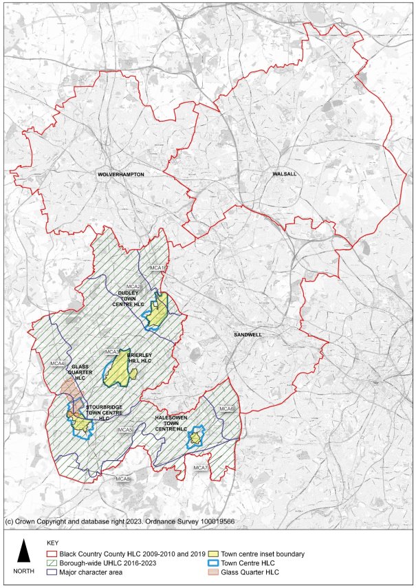
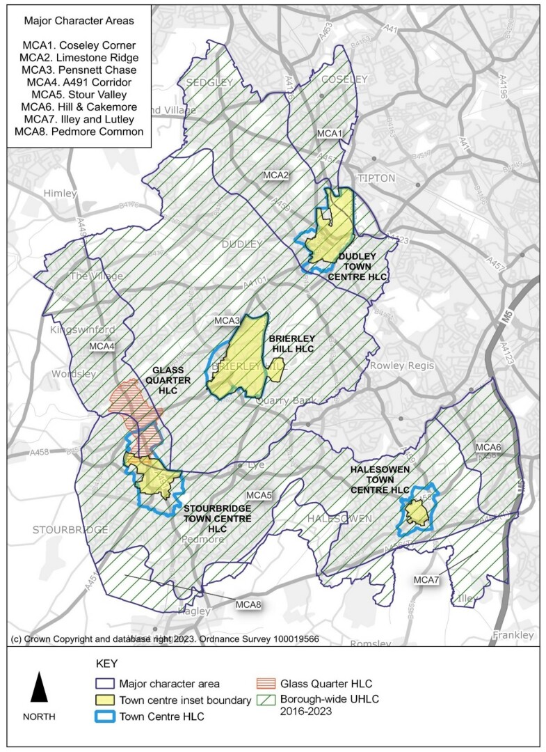
Figure 14.2 Historic Landscape Characterisation studies within the Borough
Justification
14.10 Dudley has a rich and diverse historic environment, which is evident in the survival of individual heritage assets and in the local character and distinctiveness of the broader landscape. The geodiversity of the borough and the wider Black Country underpins much of the subsequent development of the area, the importance of which is acknowledged by the inclusion of the Black Country Geopark in the UNESCO Global Geopark Network. The exploitation of abundant natural mineral resources, particularly those of the South Staffordshire coalfield, together with the early development of the canal network, gave rise to rapid industrialisation and the distinctive settlement patterns that characterise the area.
14.11 Towns and villages with medieval origins survive throughout the area and remain distinct in character from the later 19th century industrial settlements, which typify the coalfield and gave rise to the description of the wider Black Country area as an "endless village" of communities, each boasting a particular manufacturing skill for which many were internationally renowned.
14.12 Beyond its industrial heartland, the character of the borough can be quite different and varied. The green borderland, most prominent in parts of the south of the borough, is a largely rural landscape containing fragile remnants of the ancient past. Undeveloped ridges of high ground punctuate the urban landscape providing important views and points of reference that define the character of the many communities. Other parts of the borough are characterised by attractive, tree lined suburbs with large houses in substantial gardens and extensive mid-20th century housing estates designed with modern principles.
14.13 This diverse character is under constant threat of erosion from modern development, some small scale and incremental and some large scale and fundamental. As a result, some of the distinctiveness of the more historic settlements has already been lost to development of a "homogenising" character. In many ways the borough is characterised by its ability to embrace change, but future changes will be greater and more intense than any sustained in the past. Whilst a legislative framework supported by national guidance exists to provide for the protection of statutorily designated heritage assets the key challenge for the future is to manage change in a way that realises the regeneration potential of the proud local heritage and distinctive character of the area.
14.14 To ensure that heritage assets make a positive contribution towards the wider economic, social and environmental regeneration of the borough, it is important that they are not considered in isolation but are conserved and enhanced within their wider context. A holistic approach to the built and natural environment maximises opportunities to improve the overall image and quality of life in Dudley by ensuring that historic context informs planning decisions and provides opportunities to link with other environmental infrastructure initiatives.
14.15 An analysis and understanding of the local character and distinctiveness of the area has been made using historic landscape characterization (HLC) principles. Locally distinctive areas of the borough have been defined and categorised as Areas of High Historic Townscape Value, Areas of High Historic Landscape Value, Designed Landscapes of High Historic Value, and Archaeology Priority Areas (BCHLCS, 2019). This builds on the work of the original Black Country Historic Landscape Characterisation (2009), other local HLC studies and plans, and the Historic Environment Record.
14.16 In order that the degree of impact of a development proposal can be fully assessed it is essential that the significance of heritage assets including their setting, is fully understood. A Heritage Assessment is therefore required for any development proposals which is likely to affect the significance of a heritage asset, including its setting. Where necessary, the Heritage Assessment should include a qualitative visual assessment to show how the proposal affects the heritage significance of its surroundings. Heritage Assessments will be needed for any proposals within or affecting; an AHHTV, AHHLV, DLHHV, APA; a Conservation Area; a Listed building; a Scheduled Monument; a Registered Park and Garden; and non-designated heritage assets such as Locally Listed buildings.
[43] NPPF Annex 2 Designated heritage asset: A World Heritage Site, Scheduled Monument, Listed Building, Protected Wreck Site, Registered Park and Garden, Registered Battlefield or Conservation Area designated under the relevant legislation.
[44] NPPF Annex 2 Heritage asset: A building monument, site, place, area, or landscape identified as having a degree of significance meriting consideration in planning decisions, because of its heritage interest. It includes designated heritage assets and assets identified by the local planning authority (including local listing).
[45] NPPF Annex 2 Significance (for heritage policy): The value of a heritage asset to this and future generations because of its heritage interest. The interest may be archaeological, architectural, artistic, or historic. Significance derives not only from a heritage asset's physical presence, but also from its setting.