

Dudley Local Plan Part One
16. Transport
Introduction
16.1The transport network is integral in keeping the borough moving, in order to support residents, businesses and ultimately the prosperity of our borough. It is fundamental that the network is improved and grown in a sustainable manner to reduce congestion, improve air quality and be resilient in a changing climate.
16.2These transport policies set out an overarching framework for achieving strategic transport objectives and improving connectivity both within the borough and to the wider transport network
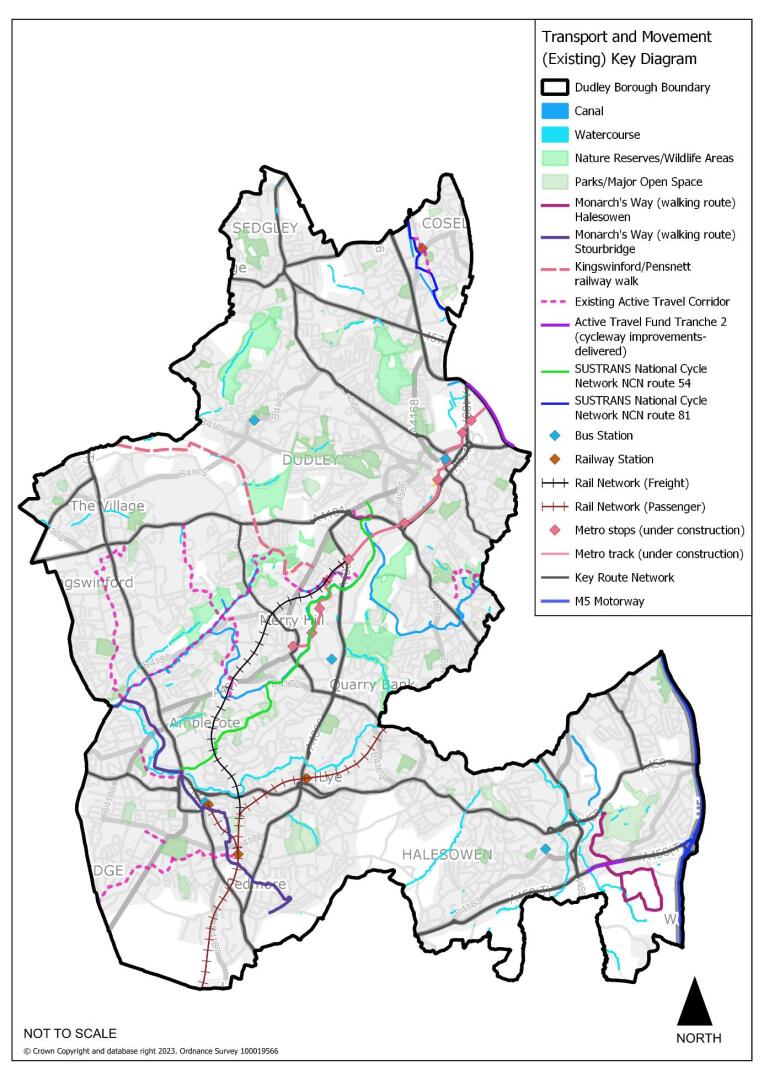
Figure 16.1 Spatial Strategy Plan: Transport
16.3National policy focuses on the need for the transport network to support sustainable economic growth, through its role in reducing carbon emissions and the impact on the natural environment. High-quality public transport remains at the heart of national transport strategy. To help address the climate change crisis, strategic and local transport policies, plans and programmes must emphasise the delivery of a modernised and sustainable transport network. Specific objectives should include reducing road congestion and pollution through improvements to public transport, promoting walking and cycling networks and reducing the need to travel.
16.4In Dudley, the development of the transport network is focused on improved public transport provision serving and linking centres, improving sustainable transport facilities, improving connectivity to national networks and improving the efficiency of strategic highway routes. The improvements needed to deliver the transport strategy are shown on the Transport Key Diagram.
16.5The DLP will need to focus on promoting the appropriate design, location and layout of development; increasing investment in infrastructure; improving the quality, equality and accessibility of public transport; supporting walking and cycling; enhancing road safety; and reducing the amount of emissions produced by transport.
Policy DLP63 The Transport Network
- The Council will undertake a programme of major and minor works to the transport network in order to further integrate and improve:
- public transport
- traffic management
- active travel schemes
- road safety
- access to enable the regeneration of specific sites and areas.
- micro-mobility
- car share schemes
- Land needed for the implementation of priority transport projects will be safeguarded to allow for their future delivery.
- All new developments must provide adequate access for all modes of travel, including walking, cycling and public transport. Residential development will be expected to meet the accessibility standards set out in Policy DLP11 of this plan.
- Key transport corridors will be prioritised through the delivery of infrastructure to support active travel (walking, cycling), public transport improvements, traffic management (including localised junction improvements) and road safety, and road space reallocation where appropriate.
- The regional strategic transport network will be taken into account in planning decisions. Key transport priorities identified for delivery and enhancement currently include (but are not limited to) the following:
Key Road Corridors
- A4123 Corridor
- A461 Corridor
- A456 Corridor
- A458 Corridor (Lye)
Interchanges
- Dudley Town Centre Interchange
- M6 Junction 10
Active Travel
- SUSTRANS Link 54(Stourbridge-BrierleyHill-Dudley)
- SUSTRANS Link 81 (Dudley/Coseley)
Justification
16.6 Good connectivity to the wider regional and national transport networks (road and rail) and Birmingham International Airport, for both passengers and freight, has been identified as being necessary to support the regeneration of the West Midlands region.
Planning for growth
16.7 The transport strategy is necessary to support the role of these centres as a focus for employment, shopping and leisure and increasingly, housing. The combination of the Wednesbury to Brierley Hill metro extension and the proposed Dudley Port Integrated Transport Hub will add both Brierley Hill and Dudley to the rapid transit network catchment area.
16.8 It is vital that new development has access to high quality sustainable/active travel infrastructure and services from the outset as this will ensure that people travelling to and from these areas do not establish unsustainable travel patterns.
16.9The DLP supports the delivery of an enhanced transport network to ensure a seamless integration of land-use and transport planning and to demonstrate the strong interdependency of future land-use decisions and adequate servicing by a variety of travel modes. This is with particular regard to Key Route Network, proposed Rapid Transit Schemes, the West Midlands and Black Country Local Cycling and Walking Infrastructure Plans (including SUSTRANS routes 54 and 81), Dudley Borough emerging Sustainable Route Network (including sustainable and active travel routes) and Dudley Borough Public Rights of Way Improvement Plan. The canal network will also provide an important asset for active and sustainable travel throughout the borough.
16.10 Public transport should reflect demand and take account of potential future economic or housing growth points to ensure an integrated approach to sustainable development and travel. This is essential to support the scale of growth proposed particularly for the regeneration corridors and strategic centres, and to create an effective transportation system to support sustainable communities.
16.11 This transport network will provide communities with access to employment, leisure, education and health care and will facilitate improved access to employment sites.
Public Transport
16.12 Movement for Growth[49] (the West Midlands Local Transport Plan) seeks to enable all residents to access Strategic Centres within 45 minutes (AM peak). It envisages this being achieved through a combination of frequent rapid transit services and high quality bus services. The vision for the metropolitan rail and rapid transit network is based on suburban rail, metro (light rail) and tram-train, very light rail and SPRINT Bus Rapid Transit lines on suitable links of one single network. The combination of the Wednesbury to Brierley Hill metro extension and the proposed Dudley Port Integrated Transport Hub will add both Brierley Hill and Dudley to the rapid transit network catchment area. This transport strategy is necessary to support the role of these centres as a focus for employment, shopping and leisure and increasingly, housing.
16.13 The Black Country Rapid Transit Study of 2016 concluded that full delivery of the Public Transport Spine would best be achieved by completing the Stourbridge to Walsall corridor as a tram-based facility (subject to the adoption of Tram-Train technology). Key routes for rapid transit schemes include:
- Wednesbury – Brierley Hill
- Birmingham – Bearwood – Hagley Road – Halesowen
- Walsall – Brierley Hill – Stourbridge (incorporating Dudley – Brierley Hill) tram-train extensions
- A4123 corridor (longer term)
16.14 Buses will continue to dominate local public transport provision in Dudley Borough throughout the life of the Plan period. The National Bus Strategy (2024) requires bus priority to be an integral part of all highway improvements. Therefore, work on the key highway corridors identified through the Key Route Network Action plans will play a significant role in delivering this requirement through a partnership of Transport for West Midlands (TfWM) and WMCA, Local Highway Authorities and operators. Specific local measures to help buses will be delivered in other locations where appropriate, along with the upgrading of bus stations/interchanges in strategic and other centres where demand resulting from new developments requires it. Coaches also have a role to play in providing affordable long-distance connectivity and access facilities and will be encouraged. As set out below under ‘planning for low emission vehicles’ a shift towards such vehicles will be a key focus alongside the provision of an adequate charging infrastructure network.
16.15 While improvement of accessibility to bus services will be a priority, some people will have little choice but to make the first part of their journey by car. The success of Park and Ride in contributing to a sustainable travel pattern will depend on minimising the distance driven before transferring to public transport. Well located Park and Ride facilities can provide a realistic alternative for many car drivers and contribute to environmental improvement by reducing congestion on radial routes into centres at peak times and by improving public transport patronage. New Park and Ride sites will be investigated and developed in accordance with the adopted West Midlands Park & Ride strategy.
16.16 As transport projects reach the design stage there will be a need to safeguard the land needed for the implementation of schemes. When projects are sufficiently advanced, improvement lines will be imposed, or land will be safeguarded.
16.17 The emerging update to the West Midlands Local Transport Plan (‘Reimagining transport in the West Midlands’ which will supersede Movement to Growth) will focus on six ‘Big Moves’: Behaviour Change; Accessible and Inclusive Places; Safe, efficient and reliable networks; Walk, wheel, cycle and scoot; Public transport and shared mobility; and a Green Transport Revolution. The Priority Transport Schemes identified within this policy will contribute towards these. As the Local Transport Plans (or ‘Area Strategies’) for the Black Country and Dudley Borough are subsequently updated to reflect the six ‘Big Moves’, additional schemes may be identified and will come under the remit of this policy.
Highway network
16.18 The operation of the highway network needs to be maintained and improved to support the growth and long-term viability of Dudley’s economy whilst limiting the environmental effect of transport usage. Decision makers must be aware of the multiple functions of the roads with the connected network such as Designated Routes for Unplanned Events, which are used for unplanned events such as Road Traffic Collisions on the Strategic Road Network, as per the latest Transport for West Midlands guidance.
16.19 The building of new highways within Dudley Borough will be mainly in support of regeneration, but there will also be a focus on works within Dudley to integrate into wider regional network improvements. For instance, some key junctions will be identified on the West Midlands Key Route Network, such as important links for public transport and to the motorway network for freight, for improvement.
16.20 Movement for Growth sets out a strategy of making the best of the existing highway network in a coordinated way through a programme of Key Route Network corridor-based multi-modal improvements, to help achieve the West Midland’s target for net zero carbon emissions by 2041.
16.21 Highway improvements will be expected to address the needs of all users especially pedestrians and cyclists and to cater for bus priority in line with current Government guidance.
Evidence
- West Midlands Strategic Transport Plan - Movement for Growth (TfWM 2016) Movement for Growth - 2026 Delivery plan for Transport (TfWM 2017)
- West Midlands Rail Investment Strategy 2022 - 2050 (WMRE 2023)
- Black Country Transport Modelling Study (2024)
- Black Country Rapid Transit Study (TfWM & BCA 2016)
- West Midlands Park & Ride Strategy (TfWM 2018)
- West Midlands Freight Strategy - Supporting our Economy, Tackling Carbon (TfWM 2016)
- Midlands Connect Strategic Transport Plan (updated in 2021/22)
- Midlands Rail Hub Outline Business Case (2022)
- West Midlands Strategic Advice (Network Rail 2022)
Delivery
- Delivery of the transport priorities will rely on several agencies and multiple funding sources. The main delivery agencies will be:
- Transport for West Midlands (TfWM)
- West Midlands Rail Executive (WMRE)
- Dudley MBC, working with the other Black Country local authorities as the Local Highways Authorities
- Network Rail
- Midlands Connect
- Canal & River Trust
- The principal vehicles for delivery will be the West Midlands Strategic Transport Plan – Movement for Growth (and subsequent Transport Plans-Reimagining transport in the West Midlands), the West Midlands Rail Investment Plan and the national Road and Rail Investment Strategies (RIS). Funding will be sought through a combination of national programmes, competitive funding streams such as the Major Route Network Fund and the Large Local Majors Fund, and through local transport settlements including City Regions Sustainable Transport Settlement (CRSTS) along with third party contributions wherever appropriate.
Safeguarding the Development of the Key Route Network
16.22 The West Midlands Key Route Network caters for the main strategic demand flows of people and freight across the metropolitan area whilst providing connections to the national Strategic Road Network. Highway capacity will be used to effectively cater for movement by rapid transit and core bus routes, the Metropolitan Cycle Network, lorries, vans and private cars. This may involve the reallocation of road space where appropriate to provide reliable, fast, high-volume transit, and will be supported by an enhanced role for Urban Traffic Management and Control (UTMC) via the West Midlands Regional Traffic Control Centre (RTCC) in ‘real time’.
Policy DLP64 The Key Route Network
- The Council, in conjunction with other regional and strategic Highway Authorities and Transport for West Midlands (TfWM) as appropriate, will identify capital improvements and management strategies to ensure the Key Route Network (KRN) meets its designated function of serving the main strategic demand flows of people and freight across Dudley Borough and the wider metropolitan area, providing connections to the national strategic road network, serving large local flows that use main roads and providing good access for businesses reliant on road-based transport.
- Land needed for the implementation of improvements to the KRN will be safeguarded in order to assist in their future delivery.
- Where new development is expected to result in adverse impacts on the KRN, appropriate mitigation measures will need to be identified through Transport Assessments and provided through Planning Obligations and/or Planning Conditions.
Justification
16.23 The West Midlands KRN not only serves the main strategic demand flows of people and freight across the metropolitan area and provides connections to the national strategic road network. It also serves large local flows which use main roads and will need to provide good access for businesses reliant on road-based transport. The network will use highway capacity effectively to cater for movement by rapid transit and core bus routes, the Metropolitan Cycle Network, lorries, vans and private cars. This will involve the reallocation of road space where appropriate to provide reliable, fast, high volume public transport and enhanced cycling, walking and wheeling facilities.
16.24 Proposals that are in line with the regional road safety aims such as Vision Zero Network and a Safe System Approach, which aim to eliminate all traffic fatalities and severe injuries, will be encouraged.
16.25 The KRN has been defined on the basis of a West Midlands Combined Authority (WMCA) definition agreed with the seven highway authorities, in consultation with neighbouring highway authorities, and features agreed performance specifications drawn up for different types of link in the network in accordance with their role for movement (“link”), and their role as a destination in its own right e.g. a suburban/town centre high street (“place”).
16.26 Improvements will be made to meet the agreed performance specification for the links and junctions involved to support road based rapid transit proposals such as SPRINT (Bus Rapid Transit) and Metro. Improvements will take into account guidance contained in the National Bus Strategy and the West Midlands Vision for Bus. All improvements to support cycling should seek to adopt the principles contained in Local Transport Note (LTN) 1/20.
16.27 Capital scheme improvements will be identified where appropriate, but it also is vital that this network is managed efficiently through the collaboration of all four Black Country Authorities (Wolverhampton, Walsall, Sandwell and Dudley) and surrounding authorities in their role as the Local Highways Authority (LHA), particularly on cross-boundary schemes.
Evidence
- West Midlands Strategic Transport Plan - Movement for Growth (TfWM 2016) Movement for Growth - 2026 Delivery plan for Transport (TfWM 2017)
- West Midlands Strategic Transport Plan (Core Strategy) – Reimagining transport in the West Midlands (TfWM 2023 and ongoing)
- Black Country Transport - Connected for Growth (BCLEP and TfWM 2019)
- West Midlands' Key Route Network Evidence Report (TfWM 2018)
- West Midlands Vision for Bus (TfWM 2018)
- Local Transport Note 1/20 (DfT 2020)
Delivery
- The overarching responsibility for the development and improvement of the Key Route Network sits with the West Midlands Mayor and Transport for West Midlands, working in partnership with the Local Highway Authority. The framework for improvement forms part of Movement for Growth (and its successor) with implementation guided by a series of KRN Corridor Action Plans.
- Funding for individual improvements will be sought through a combination of competitive funding streams (such as the DfT’s Major Route Network and Large Local Majors Funds) and from devolved local transport settlements (including CRSTS), along with third party contributions wherever appropriate.
- Where proposals cover key public transport routes, funding will also be sought through appropriate Government bus related funding opportunities.
Managing Transport Impacts of New Development
16.28 To ensure that the transport elements of the DLP are deliverable, it is essential that both new developments and existing facilities identify travel and transportation impacts and proposals for mitigation. It is important that accessibility by a choice of sustainable modes of transport is maximised. Transport Assessments and Travel Plans produced by developers, employers, schools, and facility operators are essential to bring about sustainable travel solutions and help deliver strategic transport objectives.
Policy DLP65 Transport Impacts of New Development
- Planning permission will not be granted for any proposals that are likely to have a significant adverse impact on the transport network, in terms of capacity, congestion and/or highway safety, unless accompanied by mitigation schemes that can demonstrate that an acceptable level of accessibility and safety can be achieved using all modes of transport to, from and through the development. Mitigation schemes must address in particular, access by wheeling, walking, cycling, public transport and car sharing.
- The Council will require a Transport Assessment to be submitted for major developments to assess the level of impact on the transport network and provide improvements that integrate all modes into proposed solutions, as appropriate. Transport Assessments shall also include an assessment of their impact on future transport schemes, where applicable. Where appropriate the Council will seek a Travel Plan to be implemented for the users of the development.
- The Council will require that all new development:
- Is appropriate in scale to the existing transportation infrastructure of the immediate area and transport corridor or includes measures to overcome any deficiencies.
- Actively promotes pedestrian and cycle movement, whilst ensuring safe egress and access for all highway users (including the provision of appropriate parking).
- Addresses the needs of people with disabilities and reduced mobility in relation to all modes of transport (see also Policy DLP77).
- Provides links to the public transport system, and local walking and cycling networks.
- Makes adequate provision for the managing of delivery operations, and the servicing of new properties and businesses (including emergency vehicles).
- Incorporates safe, direct and user-friendly transport links within the layout of the site, as well as active travel storage.
- Development proposals should provide a level of parking provision (including cycling) that is proportionate and appropriate to the type, scale, and location of the development, informed by Appendix 7.
Justification
16.29 All developments will be assessed both in terms of their impact on the transport network and the opportunities available to ensure that the site is accessible by sustainable modes of transport. The supporting documentation will either take the form of a full Transport Assessment (TA) or a less detailed Transport Statement (TS) and will generally be determined by the size and scale of the development or land use. This will be based on local and national guidance, with a TA sometimes being required instead of a TS based on reasons other than spatial thresholds such as road safety concerns, existing congestion problems, air quality problems, concerns over community severance or the likelihood of off-site parking being generated.
16.30 Where a development is considered to have a potential significant effect on the SRN, Highways England will be involved. In addition, under appropriate circumstances consultation with Active Travel England will also be necessary.
Delivery
- Through the Development Management process and via Planning Obligations or other legal and funding mechanisms.
The Efficient Movement of Freight
16.31 New freight railways and rail sidings could present an economic opportunity for Dudley businesses. Improved journey times on the highway network will support economic prosperity and switching traffic to rail or inland waterways will relieve the highway network of traffic, thereby reducing congestion and improving air quality and protecting the environment. The siting of businesses producing heavy flows of freight vehicles in locations with good access to the principal highway network will also assist with environmental improvement. Improvements to the freight network are a significant element to achieving environmental transformation and economic prosperity.
Policy DLP66 The Movement of Freight
- The movement of freight by sustainable modes of transport such as rail and waterways will be encouraged. Road-based freight will be encouraged to use the Key Route Network whenever practicable.
- Junction improvements and routeing strategies will be focussed on those parts of the highway network evidenced as being suitable and appropriate for freight access to employment sites and the motorway network.
- Proposals that generate significant freight movements will be directed to sites with satisfactory access to the Key Route Network.
Justification
16.32 Heavy Goods Vehicles account for 20% of all transport emissions with Light Duty Vehicles accounting for 17%[50], meaning the road freight sector contributes 37% of transport emissions, despite freight representing just 23% of all vehicle miles undertaken in the UK[51]. Making the most efficient use of the highway network whilst providing facilities to transfer freight from road to rail and inland waterways will play a major part in achieving the region’s climate change targets.
16.33 Within the Black Country, freight traffic has always been particularly important reflecting the area’s past level of manufacturing and it remains significant today with industry, distribution and logistics giving rise to much freight traffic. This is reflected in both the M5 and M6 motorways, where the proportion of heavy goods vehicles can be 30% of total traffic, and the local road network, where the traffic on many main routes have an exceptionally high percentage of heavy goods vehicles.
16.34 The design and layout of much of the KRN dates from a period when goods vehicles were significantly smaller and lighter than those currently in use and this gives rise to problems of reliability and with deliveries and servicing. In many cases upgrading of these routes is neither economically viable nor environmentally desirable.
16.35 Dudley Council is a member of the West Midland’s Freight Quality Partnership, as are freight operators and their national representative bodies. The Regional Freight Strategy (2016) sets a context for planning for freight within Dudley. Removal of freight from the road to rail or canal will reduce congestion, and support investment in rail and canals.
16.36 The railway network serving the region suffers from capacity problems during the day when there is high demand for passenger services, and this has shifted much freight traffic to night-time operation. Of the disused lines the most important is Stourbridge-Walsall-Lichfield, which has been identified in the Regional Freight Strategy as being an important link for freight moving between the southwest and northeast regions. Within the West Midlands conurbation, the Stourbridge to Lichfield link would act as a bypass for the rail network around Birmingham which has severe capacity constraints. The capacity released by the reopening of Stourbridge-Walsall-Lichfield link would allow extra passenger services to operate to and through Birmingham to the benefit of the wider West Midlands.
16.37 The Regional Freight Strategy notes a shortage of private sidings in the West Midlands Region. Sites with existing or potential rail access along existing and proposed freight routes particularly Stourbridge to Walsall and Walsall to Lichfield will be protected for rail related uses.
16.38 The Freight Strategy notes the need to address the increased importance of ‘last mile’ logistics and the role that transport innovation can play in this, e.g., parcel hubs, e-cargo bikes, micromobility and EV charging facilities for sustainably fuelled delivery vehicles.
Evidence
- West Midlands Freight Strategy - Supporting our Economy, Tackling Carbon (TfWM 2016)
- West Midlands Strategic Transport Plan - Movement for Growth (TfWM 2016)
- Movement for Growth - 2026 Delivery plan for Transport (TfWM 2017)
- West Midlands Strategic Transport Plan (Core Strategy) – Reimagining transport in the West Midlands (TfWM 2023 and ongoing)
- West Midlands' Key Route Network Evidence Report (TfWM 2018)
- West Midlands Strategic Advice (Network Rail, 2022)
Delivery
- The West Midlands Freight Strategy will guide the delivery of measures to improve the movement of freight. The rail-related elements will ultimately be delivered through a combination of Network Rail and the private sector against the background of the national Rail Investment Strategy and the regional Freight Strategy.
- The overarching responsibility for the development and improvement of the KRN sits with the West Midlands Mayor and Transport for West Midlands, in partnership with the Local Highway Authority. The framework for improvement forms part of Movement for Growth with implementation guided by a series of KRN Corridor Action Plans.
Active Travel
16.39The development of sustainable modes of travel to encourage people out of their cars, particularly for shorter and commuter journeys, is an important element of planning and transport strategy. Places need to be well-connected with attractive, convenient, direct and safe routes available to non-car users, thus providing real choice.
16.40 The cycle network in the West Midlands consists of three tiers: -
- The National Cycle Network (NCN) – identified and developed by Sustrans in partnership with local authorities and shown on the Transport Key Diagram. This network provides long distance routes across the country linking major destinations.
- The Metropolitan Network (known as the Starley Network) – identified by WMCA in Movement for Growth and developed through the West Midlands Cycling & Walking Infrastructure Plan (WM LCWIP). These routes link strategic locations in the West Midlands and are also shown on the Transport Key Diagram
- Local Networks – this builds upon the West Midlands LCWIP, and includes the Black Country LCWIP and Dudley’s emerging Sustainable Route Network.
16.41 The emerging Black Country and Dudley Networks for Cycling will provide greater detail on the Dudley sections of the West Midlands LCWIP and will identify the most important links in the Local Network.
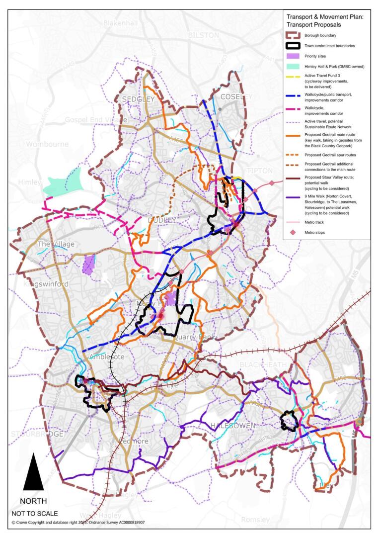
Figure 16.2 Spatial Strategy Plan: Active Travel
Policy DLP67 Active Travel
- New development will link to existing walking and cycling networks, through safe and direct pathways, not impeded by infrastructure provided for other forms of transport, unless there is robust evidence provided as to why this is not viable and/or practical.
- Cycle parking facilities should be provided at all applicable new developments and should be in convenient locations with good natural surveillance, with the number of cycle secure parking spaces required in new developments and in public realm schemes, informed by Appendix 7.
- The following networks and other linkages within Dudley Borough are considered priorities for potential enhancement and expansion as cycle routes and strategic footpaths. This includes their signposting and delineation, and their environment upgraded with an emphasis on enhanced green infrastructure.
- SUSTRANS Link 54 (Stourport-Brierley Hill-Dudley)
- SUSTRANS Link 81 (Dudley/Coseley)
- The River Stour (Stour Valley) active travel network
- The Geo-Park/Geo-Trail active travel network
- The 9 Mile Walking Route from Norton Covert, Stourbridge, to The Leasowes, Halesowen
- Monarch’s Way
- In addition, the Council will support the enhancement and expansion of cycle routes and strategic footpaths involving
- The canal network
- Disused railway lines
- Links to existing shopping centres
- National and regionally recognised footpaths
- Links to public transport nodes, stops and interchanges
- Within accessible neighbourhoods, to readily access local services and facilities
Justification
16.42It is essential that the development of walking and cycling facilities are an integral part of the transport system both on the highway network, canal corridors, Public Rights of Way and on other paths. The development of comprehensive cycle and walking networks within Dudley will enable communities to access employment, public transport interchanges, services, and facilities in a sustainable way.
16.43 A transport network that facilitates car use and disadvantages walking and cycling can adversely affect the health and wellbeing of its communities. Identifying and overcoming barriers to walking and cycling through new development will encourage a renaissance of walking and cycling within Dudley and help improve the health and wellbeing of local communities by reducing the incidence of obesity, coronary heart disease, strokes, and diabetes. Both walking and cycling are active modes of travel with clear health benefits.
16.44 The implementation of such networks recognises the specific requirements of each with dedicated, segregated cycling provision being the default objective along with a comprehensive network of walking opportunities available both on highway and off road.
16.45 Walking and Cycling Strategies are incorporated within Movement for Growth and its successor. The over-arching framework is the West Midlands Local Cycling & Walking Infrastructure Plan (LCWIP). This will be supported by the emerging Black Country LWCIP. All new cycle facilities will aim to be designed in accordance with guidance set out in Local Transport Note (LTN) 1/20 and TfWM’s Cycle Design Guidance, or superseding guidance.
16.46Joint working between Dudley Council, neighbouring authorities, Transport for West Midlands, West Midlands Combined Authority, Canal and River Trust, Active Travel England and other regional strategic Highway Authorities will ensure that a comprehensive, integrated, attractive and well-designed cycle and footpath network is created, improved and maintained to serve the West Midlands region including Dudley borough.
16.47 Several cycle route corridors are being progressed for future development, including those in and around the borough’s strategic and town centres (see the relevant sections for further details). These link into wider borough corridor projects which currently include:
- A4123 - Wolverhampton via Dudley and Sandwell to Birmingham
- A4101 Stourbridge Road/Queens Cross to Scott’s Green Island - links into Sustrans Route 54 improvements
- A461 Dudley Port (Sandwell) - Burnt Tree to Queens Cross through to Bretell Lane, Audnam (via Brierley Hill)
- A456, Manor Way - M5 junction 3 to Hayley Green
- A458 - key sections
- Smestow Valley - Pensnett to Holbeche House (west of Ham Lane)
- Improvements to existing cycle corridors
Evidence
- West Midlands Strategic Transport Plan - Movement for Growth (TfWM 2016) Movement for Growth - 2026 Delivery plan for Transport (TfWM 2017)
- West Midlands Strategic Transport Plan (Core Strategy) – Reimagining transport in the West Midlands (TfWM 2023 and ongoing)
- Black Country Cycling Strategy (BCA 2021)
- Black Country Transport Modelling Study (2024)
- West Midlands Cycle Design Guidance (TfWM 2022)
- Department for Transport (2020) Cycle Infrastructure Design Local Transport Note 1/120.
Delivery
- The Metropolitan Cycle Network will be delivered through the West Midlands Local Cycling & Walking Infrastructure Plan. Funding will be sought from a variety of competitive and devolved sources such as the Transforming Cities Fund and Intra-City Transport Fund.
- The delivery of most local cycle links will be through the Local Cycling & Walking Implementation Plan (LCWIP) and Sustainable Local Travel Routes Plan.
- The Black Country’s extensive network of canals affords numerous opportunities to contribute to the delivery of a comprehensive network of safe, off-road, cycle routes. The Canal & River trust will therefore be a key delivery partner.
- Where appropriate opportunities afforded by Highways England’s Designated Fund Programme will be utilised. This aims to address specific issues such as safety and severance resulting from the interface between the Strategic Road Network and local routes.
Parking Management
16.48 The management of car parking has a key role in reducing the number and impact of vehicle trips, which in turn can lead to improvements in air quality and a reduction in carbon emissions.
Policy DLP68 Parking Management
- The priorities for traffic management in the Dudley Borough include the sustainable delivery and management of parking in centres and beyond, through use of some or all of the following measures as appropriate:
- the management and control of parking.
- the type of parking – ensuring that where appropriate long-stay parking is managed and minimised in town centres, to support parking for leisure and retail customers and to encourage commuters to use more sustainable means and reduce peak hour traffic flows.
- the location of parking – by reviewing the location of town centre car parks through the “Network Management Duty”, to ensure that the flow of traffic around town centres is as efficient as possible.
Justification
16.49 The correct balance needs to be found between managing and pricing parking to maximise the use of sustainable travel means to enter town centres, whilst avoiding restricting parking to the extent that consumers are dissuaded from using town centres and deterring new development.
16.50 The control of and management of parking in centres will require a variety of approaches, recognising that not all publicly available car parking is in local authority control or management. The use of planning conditions to ensure that new public parking is managed appropriately will therefore be an important aspect of this policy. Furthermore, proposals that use up to date technology regarding parking and payment will be welcomed.
16.51 The continued adoption of maximum parking standards for all but residential development is considered to be an important tool in managing demand for single occupancy vehicle trips and journeys to centres and major employment destinations, leisure and other facilities.
16.52 Reduced levels of long-stay car parking in centres will enable more efficient use of land.
Evidence
- Black Country Parking Study (BCA, 2021)
- West Midlands Park & Ride Strategy (TfWM, 2018)
Delivery
- This policy will be delivered through the Council’s network management duty and parking management policies.
- The management of new privately owned and operated public car parks will be controlled through Parking Management Plans via planning conditions or planning obligations through the Development Management process.
Planning for Low Emission Vehicles
16.53 The UK government has committed to banning the sale of petrol and diesel cars by 2030. The resultant societal shift from petrol and diesel internal combustion engine (ICE) vehicles to Zero and Ultra Low Emission Vehicles (ULEVs) will require widespread support from local authorities. According to data from the Insights Toolkit (Cenex 2023), it is projected that there will nearly 1.4 million electric vehicles in Dudley by 2041 (up from c.18,500 in 2023). The Black Country ULEV Strategy sets out a framework for how Dudley Council and the other BCAs can support this transition.
Policy DLP69 Planning for Low Emission Vehicles
- The Council will support the development of low emission vehicle technologies and provide facilities and measures which enable the ease of use of low emission vehicles, by:
- Ensuring that new developments include adequate provision for charging infrastructure in accordance with current legislative and regulatory guidelines.
- Encouraging Low Emission Vehicle Use through travel plans and other initiatives.
- Facilitating the introduction of charging points in public locations where appropriate.
Justification
16.54 In July 2019, the West Midlands Combined Authority committed to setting a ‘net zero’ emissions target by 2041, with a climate action plan being approved by the WMCA board by January 2020. The WMCA Board further approved a regional ULEV strategy in February 2020. The Black Country ULEV Strategy sits under this regional document. In addition, ‘Green Transport Revolution’ is one of the six ‘Big Moves’ within the emerging West Midlands Local Transport Plan and is focused on accelerating the shift away from internal combustion engines.
16.55 Whilst the WMCA ULEV Strategy focusses on sharing best practice, co-ordination and possible joint delivery of a large-scale network of rapid charging ‘hubs’, the Black Country ULEV Strategy takes a more granular approach, focussing on the specifics of each authority and offering a framework for the delivery on infrastructure on the ground.
16.56 The study found that the Black Country lags behind the rest of the country when it comes to adoption of ULEVs. This is reflected in the availability of charging infrastructure across the four authorities, with around 80% of the sub-region further than one km from the nearest publicly available charge point. However, relative to median wage, all four Black Country authorities sit on or above the trend for ULEV adoption, indicating higher uptake than might be expected given the average wage across each of the four authorities.
16.57 Despite progress in recent years, our charging infrastructure network is not yet where it needs to be. We need to get infrastructure to where users need it; at home (for areas where there is little or no off-street parking), enroute for longer journeys and at the destinations people travel to. The requirement for adequate charging networks also applies to the Local Authority Council Depots and will need to be a key component of the Council’s Fleet Strategy moving forward. The ULEV Strategy contains several electric vehicle related commitments including a commitment to develop a Council vehicle replacement strategy to ensure that Dudley’s vehicle fleet is upgraded in a way that supports the net-zero targets and can be financed within identified budgets.
16.58 Close working between Dudley Council and TfWM is also enabling the trial of mobility hubs (local travel points) in 2023/24. This, it is anticipated, will lead to lessons learnt to inform the wider regional roll out of mobility hubs (up to 40 across the region by 2027). Mobility hubs are stations of publicly managed vehicles (EV cars, cycles, micro-mobility and parcel collection unit) within an improved public realm space. This it is envisaged will encourage use of carbon efficient travel whilst reducing the need for large capital outlays to purchase vehicles.
Evidence
- Black Country Air Quality Supplementary Planning Document (BCA 2016)
- West Midlands ULEV Strategy (TfWM 2020)
- Black Country ULEV Strategy (Cenex on behalf of BCA 2020)
- Emerging WMCA ZEV Charging and Refuelling Strategy
Delivery
- Delivery will be achieved through the use of the Black Country ULEV Strategy as a framework to support bids for Central Government funding for public EV charging infrastructure as well as providing guidance for the provision of infrastructure in public sector-owned locations.
- The Black Country Air Quality SPD will continue to provide guidance for the provision of charge points through the planning process.
[49] West Midlands Strategic Transport Plan – Movement for Growth (TfWM 2016)/ Movement for Growth – 2026 Delivery Plan for Transport (TfWM 2017)
[50] Department for Transport (2023). Transport and environment statistics: 2023. Available from: https://www.gov.uk/government/statistics/transport-and-environment-statistics-2023/transport-and-environment-statistics-2023
[51] Department for Transport (2023) Road Traffic Estimates in Great Britain 2022L Traffic in Great Britain by Vehicle Type. Available from: https://www.gov.uk/government/statistics/road-traffic-estimates-in-great-britain-2022/road-traffic-estimates-in-great-britain-2022-traffic-in-great-britain-by-vehicle-type
