

Dudley Local Plan Part One
11. Environment
Introduction
11.1Dudley enjoys a unique physical and cultural heritage thanks to its origins as a mainstay of heavy industry and driver of the Industrial Revolution. The geological complexity of the area, its topography, its settlement patterns, and the existence of significant areas of green and open space within a large population require a set of robust and relevant planning policies that will help to protect and enhance what gives the borough its unique physical, ecological and historic character and appearance. Despite its mainly urban character, Dudley has an extensive network of formal and informal green spaces and designated nature conservation sites that form the green infrastructure network for the borough.
11.2The protection and improvement of the borough’s biodiversity and geodiversity will improve the attractiveness of the area for people to live, work, study and visit while at the same time improving the physical and natural sustainability of the conurbation in the face of climate change. This will directly contribute to achieving Strategic Priorities one and two.
11.3The DLP addresses a number of established and evolving topic areas, including the natural and historic environments, air quality, flooding and climate change.
11.4The importance of green infrastructure, in achieving a healthy and stable environment, is reflected throughout the Plan and is supported in this section by policies on trees and Biodiversity Net Gain (BNG).
11.5The importance of the borough in terms of its contribution to geological science and the environment is recognised by being part of the Black Country UNESCO Global Geopark, which is also reflected in a planning policy for the first time.
11.6Within the borough is Fens Pool Special Areas of Conservation (SAC). This site is of European importance and the DLP has a major role to play in ensuring its special environmental qualities are not impacted adversely by development.
Figure 11.1 Spatial Strategy Plan: Environment
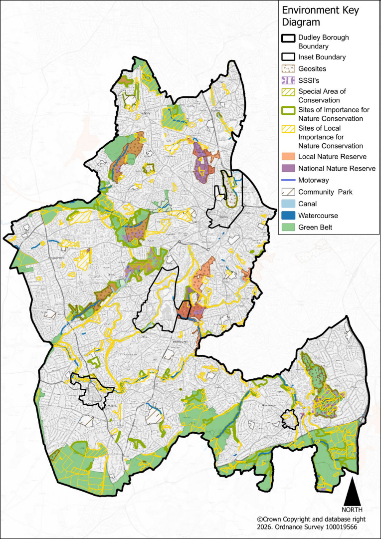
Nature Conservation
11.7The protection and improvement of the borough’s biodiversity and geodiversity will safeguard and improve the environmental attractiveness and value of the area for residents and visitors, while at the same time improving the physical and natural sustainability of communities within the wider conurbation in the face of climate change. This will directly contribute to delivering Strategic Priority one, which is also associated with supporting the physical and mental wellbeing of residents.
Policy DLP31 Nature Conservation
- Development within Dudley will safeguard nature conservation, whether inside or outside its boundaries, by ensuring that:
- development will not be permitted where it would, alone or in combination with other plans or projects, have an adverse impact on the integrity of a European or internationally designated site, including Special Areas of Conservation (SAC);
- development causing adverse impact on nationally designated sites, Sites of Special Scientific Interest (SSSI) or National Nature Reserves (NNR) should not normally be permitted except where the benefits of the development in the location proposed would clearly outweigh both its likely impact on the features of the site that make it of special scientific interest, and any broader impacts on the national network of SSSI;
- development causing adverse impact on regionally important Local Nature Reserves (LNR) and Sites of Importance for Nature Conservation (SINC) designated nature conservation sites should be avoided unless the benefits of the development clearly outweigh the importance of the site and the features that it contains, and any damage caused must be minimised. Any remaining impacts must be fully mitigated, and compensation will only be accepted in exceptional circumstances;
- development causing adverse impact on locally important nature conservation sites (Sites of Local Importance for Nature Conservation (SLINC)), important habitats and geological features should be avoided unless sufficient mitigation and justification can be provided;
- the movement of wildlife within Dudley and beyond, through both linear habitats (e.g. wildlife corridors) and the wider urban matrix (e.g. stepping-stone sites) is not impeded by development;
- species that are legally protected, in decline, rare within Dudley and the sub-region or that are covered by Biodiversity Action Plans (BAPs) will be protected when development occurs in accordance with Part I of the Wildlife and Countryside Act 1981.
- Sufficient information must be submitted with planning applications for proposals that may affect any designated site or important habitat, species, or geological feature, to ensure that the likely impacts of the proposal can be fully assessed.
- Functionally, or physically related development should seek to positively contribute to the natural environment of Dudley by:
- extending and improving the condition of nature conservation sites;
- improving wildlife movement;
- restoring or creating habitats / geological features that actively contribute to the implementation of Nature Recovery Networks, and the most up to date biodiversity and geological strategies at a national, regional, or local level.
- ensuring that watercourse-side developments deliver improved and extended corridors for the movement of wildlife and people.
Justification
11.8The past development and redevelopment of the borough along with the rest of the Black Country, has led to it being referred to as an “endless village”[8], which describes the interlinked settlements and patches of encapsulated countryside present today. The wider Black Country is home to internationally and nationally designated nature conservation sites and has the most diverse geology, for its size, of any area on Earth[9]. Many rare and protected species are found thriving within its matrix of greenspace and the built environment.
11.9Sitting at the heart of the British mainland the borough can play an important role in helping species migrate and adapt to climate change as their existing habitats are rendered unsuitable. It is therefore very important to increase the ability of landscapes and their ecosystems to adapt in response to changes in the climate by increasing the range, extent, and connectivity of habitats. In order to protect vulnerable species, the Nature Recovery Network process, which is taking place at a national level, will allow isolated nature conservation sites to be protected, buffered, improved, and linked to others. This will be supplemented by the Black Country Nature Recovery Network Strategy and subsequent work, which all development will be required to consider as set out under Policy DLP32. When considering the movement of wildlife, development proposals should incorporate the recommendations from the Black Country Local Nature Recovery Opportunity Map and Strategy and the ecological networks identified in this document. Species dispersal will be aided by extending, widening, and improving the habitats of wildlife corridors. Conversely, fragmentation and weakening of wildlife sites and wildlife corridors by development will be opposed.
11.10Sites of Importance for Nature Conservation (SINC’s) and Sites of Local Importance for Nature Conservation (SLINC’s) are identified though the process of Local Site Assessment. This process is overseen by the Birmingham and Black Country Local Sites Partnership. The role of the Partnership is to provide expert advice to the area’s local authorities and other organisations as appropriate on the selection, management, protection and review of the network of local sites throughout Birmingham and the Black Country. The Partnership comprises representatives of all the organisations involved in the operation of the local sites system.
11.11Where a development would impact upon a SINC, SLINC or, where deemed necessary, a Potential Sites of Importance (PSI) a Local Sites Assessment maybe required to be submitted to the Local Sites Partnership. Assessments will need to follow the most recent local sites guidance for selection. If sites are endorsed by the Partnership, then the relevant procedures to adopt and designate local sites within Dudley will be carried out. It is particularly important to protect and enhance SINCs; an up-to-date Local Site Assessment will be required to support any proposal that could potentially impact upon or harm a SINC.
11.12Throughout the plan period, Dudley will review and update evidence on designated nature conservation sites and LNRs with the Local Sites Partnership and Natural England. Site protections may be revised accordingly. The Local Environmental Records Centre maintains and shares this information on behalf of the Council.
11.13Development offers an opportunity to improve the local environment, and this is especially so in an urban area. Dudley is committed to meeting its “Biodiversity Duty” under the Natural Environment and Rural Communities Act (2006) and to delivering the principles of the NPPF by proactively protecting, restoring and creating a richer and more sustainable wildlife and geology. The local Biodiversity Partnership, Geodiversity Partnership, Birmingham and Black Country Local Nature Partnership and Local Sites Partnership will identify, map, and regularly review the priorities for protection and improvement throughout the Black Country, in accordance with the Black Country Nature Recovery Network strategy. These will be used to inform planning decisions.
11.14Proposals for new developments are also encouraged to make use of Natural England’s Green Infrastructure Framework to ensure that there are opportunities for the assets that make up this network to be better managed for the environment and to deliver a wider range of multifunctional benefits.
11.15Details of how improvements (appropriate to their location and scale) will contribute to the natural environment, and their ongoing management for the benefit of biodiversity and geodiversity, will be expected to accompany planning applications. Proposals should be informed by Local Nature Recovery Strategies. Additional guidance will be provided within SPD’s where relevant.
Evidence
- EcoRecord - Birmingham and Black Country Local Environmental Records Centre
- Birmingham and Black Country Local Sites Assessment Reports
- Black Country Local Nature Recovery map and strategy: an emerging approach (2022)
- Biodiversity Action Plan for Birmingham and the Black Country (2010)
- West Midlands Local Nature Recovery Strategy 2025
- Geodiversity Action Plan for the Black Country (2005)
- An Ecological Evaluation of the Black Country Green Belt (2019)
Delivery
- Biodiversity and Geodiversity Action Plans
- Development and implementation of Black Country Nature Recovery Strategy
- Updated ecological surveys and Local Sites Assessment Reports, as appropriate
- Development Management process
Nature Recovery Network and Biodiversity Net Gain
11.16The Nature Recovery Network (NRN) is a major commitment in the government’s 25 Year Environment Plan. The government has set out in the Environment Act (2021) that a Local Nature Recovery Strategy (LNRS) will be prepared locally and published for all areas of England, and that these will:
- agree priorities for nature’s recovery;
- map the most valuable existing habitat for nature using the best available data; and
- map specific proposals for creating or improving habitat for nature and wider environmental goals.
11.17The LNRS will help restore many ecosystem functions and improve the services upon which society depends, benefitting nature, people and the economy, and helping to address three of the biggest challenges society faces: biodiversity loss, climate change and human wellbeing.
11.18LNRSs will support delivery of mandatory biodiversity net gain and provide a focus for a strengthened duty on all public authorities to conserve and enhance biodiversity, which were also introduced by the Environment Act (2021). They will underpin the Nature Recovery Network, alongside work to develop partnerships and to integrate nature into incentives and land management actions.
11.19Biodiversity Net Gain (BNG) is a process that attempts to leave the environment in a more valuable and richer condition than it was found to be in previously. The Government has set out in the Environment Act (2021) that development proposals are required to provide a minimum 10% uplift in habitat quality where sites are being developed.
11.20This process involves the use of a metric as a proxy for recognising the negative impacts on habitats arising from a development and calculating how much new or restored habitat, and of what types, is required to deliver sufficient net gain.
11.21Policy DLP32 sets out how development proposals will be required to consider the Local Nature Recovery Strategy and how BNG will be secured.
Policy DLP32 Nature Recovery Network and Biodiversity Net Gain
- All qualifying developments hall deliver a minimum 10% net gain in biodiversity value when measured against baseline site information when calculated using the most current national Biodiversity Metric.
- BNG shall be provided in line with the following principles:
- delivery of BNG using on-site habitat provision / enhancement wherever practicable is expected, followed by improvements to sites within the local area, and then other sites elsewhere within Dudley;
- the maintenance and where possible enhancement of the ability of plants and animals (including pollinating insects) to move, migrate and genetically disperse across Dudley and the Black Country;
- the provision / enhancement of priority habitats identified at the national, regional, or local level, having regard to the scarcity of that habitat within Dudley and the Black Country;
- Where required, off-site habitat enhancement or creation, will be encouraged to be local (within the borough boundary) to the development site unless it can be demonstrated that an alternative means of compensation would have a more beneficial biodiversity outcome.
- Planning permissions must include monitoring plans with clear indicators[10] of the type and amount of BNG delivered, to support future plan reviews.
Justification
11.22Locally developed Nature Recovery Strategies (LNRS) are required by the Environment Act (2021). LNRS will help to map the Nature Recovery Network locally and nationally, and will help to plan, prioritise and target action and investment in nature at a regional level across England.
11.23The Environment Act (2021) introduces a new duty on all public bodies to have regard to any relevant LNRS, creating an incentive for a wide range of organisations to engage with the creation of an LNRS and to take steps to support its delivery. Local authorities and other public bodies designated by the Secretary of State will also have to report on what steps they have taken, at least every five years.
11.24Dudley alongside the other Black Country Authorities commissioned a ‘Black Country Local Nature Recovery map and strategy: an emerging approach’. This has produced opportunities mapping that future development proposals will be required to consider in demonstrating how they deliver benefits appropriate to the zones identified. The Nature Recovery Network Opportunities Map is shown in the emerging approach, alongside a description of the components of the opportunities map.
11.25The Black Country Local Nature Recovery map and strategy will eventually be superseded by the West Midlands LNRS that is being produced. In the meantime, the Black Country Local Nature Recovery map and strategy will carry weight as evidence supporting DLP32, until such time as the West Midlands LNRS is adopted.
11.26The Environment Act underpins the government’s approach to establishing the NRN. The Environment Act sets the framework for at least one legally binding biodiversity target, establishes spatial mapping and planning tools to identify existing and potential habitat for wildlife and agrees local priorities for enhancing biodiversity in every area of England (LNRS); creates duties and incentives, including mandatory biodiversity net gain.
11.27BNG has been described as a measurable target for development projects where impacts on biodiversity are outweighed by a clear mitigation hierarchy approach to first avoid and then minimise impacts, including through restoration and / or compensation.
11.28A locally specific BNG policy helps Dudley to identify opportunities for the delivery of BNG delivery and determine the ‘strategic significance’ score that is part of the Biodiversity Metric. In this way, BNG can help meet local objectives in addition to contributing to wider nature recovery plans; this will ensure that the right habitats are provided in the right places. Including BNG in the Local Plan can also link biodiversity to other strategic objectives and the overall place-making strategy for an area, enabling a more holistic approach to the environment.
11.29Net gain is an approach to development, and / or land management, which aims to leave the natural environment in a measurably better state than beforehand.
11.30The encouraging of local delivery within the borough boundary is emphasised where off-site compensation is required. The nearby locality of off-site delivery is incentivised by the ‘Spatial Risk Multiplier’ within the biodiversity metric calculator. This multiplier is applied when the off-site compensation is within the Local Planning Authority’s boundary or within the same National Character Area (NCA) as the impact site. Dudley is covered by three NCA’s, all of whose boundaries extend beyond the borough boundary. Assuming that delivery is appropriate to the local area, the LPA would like to encourage delivery within extent of the NCA which lies within the borough.
11.31Mandatory BNG provides a financial incentive for development to support the delivery of LNRSs through an uplift in the calculation of biodiversity units created at sites identified by the strategy. LNRSs have also been designed to help local planning authorities deliver existing policy on conserving and enhancing biodiversity and to reflect this in the land use plans for their area.
11.32The Environment Act (2021) proposes that new developments must demonstrate a minimum 10% increase in biodiversity on or near development sites. New development should always seek to enhance rather than reduce levels of biodiversity present on a site. This will require a baseline assessment of what is currently present, and an estimation of how proposed designs will add to that level of biodiversity, supported by evidence that a minimum 10% net gain has been delivered.
11.33Development generates opportunities to help achieve an overall nature conservation benefit. It will often be possible to secure significant improvements through relatively simple measures, such as the incorporation of green and blue infrastructure and features including bird / bat boxes and bricks that can enable wildlife to disperse throughout the borough.
11.34Provision of on-site or off-site compensation should not replace or adversely impact on existing alternative / valuable habitats in those locations and should be provided prior to development. BNG plans will need to be agreed prior to commencement[11], subject to appropriate legal agreements and conservation covenants. Sites and areas identified to provide for BNG requirements should be managed and monitored for at least 30 years post-provision, via obligations or conservation covenants.
11.35Biodiversity features of value frequently occur beyond designated sites and should be conserved, enhanced and additional features created as part of development.
11.36On-site biodiversity improvements will also be vital to enhancing the liveability of urban areas, and improving the connection of people to nature, particularly as development densities increase. Development should also contribute to wildlife and habitat connectivity in the wider area, in line with the Birmingham and Black Country Biodiversity Action Plan and the Black Country Local Nature Recovery Network Strategy.
11.37The ways in which developments secure a net gain in biodiversity value will vary depending on the scale and nature of the site. On some sites, the focus will be on the retention of existing habitats. For others, this may be impracticable, and it may be necessary instead to make significant provision for new habitats either on- or off-site.
11.38It can be challenging to establish new habitats. It is essential that the most important and irreplaceable habitats are protected, and so mitigation rather than retention will not be appropriate in some circumstances.
11.39Over the lifetime of the Local Plan the council intends to develop numerous sites across the borough as habitat banks to allow for the provision of locally sourced biodiversity units. Once developed a list detailing the units available and location of these sites will be published.
Evidence
- The Environment Act 2021
- The Government’s 25 Year Environment Plan
- Nature Networks Evidence Handbook - Natural England Research Report NERR081
- Making Space for Nature (Lawton et al. 2010)
- DEFRA Statutory Biodiversity Metric
- Biodiversity Net Gain – Principles and Guidance for UK Construction and Developments – CIEEM
- Black Country Local Nature Recovery map and strategy: an emerging approach (2022)
- West Midlands Local Nature Recovery Strategy 2025
- The Severn River Basin Management Plan
Delivery
- Development Management, legal and funding mechanisms.
- BNG plans accompanying development proposals.
Provision, retention and protection of trees, woodlands, and hedgerows
11.40Section 197 of the Town and Country Planning Act 1990 places a duty on the Local Planning Authority to secure the planting of new trees. Dudley MBC will secure the planting of new trees in locations where they will complement the surrounding architecture and the local landscape. The council will seek to ensure that the species of tree planted is suitable for each location.
11.41A main theme of the Government’s 25-Year Environment Plan is the need to plant more trees. This is to be achieved not only as part of the creation of extensive new woodlands but also in urban areas; this will be accomplished in part by encouraging businesses to offset their emissions in a cost-effective way through planting trees. The national ambition is to deliver one million new urban trees and a further 11 million new trees across the country by 2060.
Policy DLP33 Provision, retention and protection of trees, woodlands, Ancient Woodland, and Veteran trees
Retention and protection of trees and woodland
- Development that would result in the loss of or damage to ancient woodland, veteran or ancient trees will not be permitted unless there are wholly exceptional reasons and a suitable compensation strategy exists.
- Other trees that positively contribute to public amenity and air quality management will be protected unless sound arboricultural reasons support their removal[12].
- The planting of new, species diverse, trees and woodlands will be sought, in appropriate locations, to increase the extent of tree canopy cover in Dudley to a minimum of 20% and all major residential and commercial development must be designed to meet these targets.
Habitat Creation
- All major developments are encouraged to retain or deliver a minimum of 20% canopy cover (estimated growth 25-years from planting[13]), with the emphasis on retaining existing established trees, unless a lesser figure can be justified by viability or other evidence. Where it can be demonstrated that the policy requirement cannot be met by trees alone, other green infrastructure elements maybe integrated in to the development.
- In addition to meeting the requirements for replacement trees new tree planting should be included in all new residential developments and other significant proposals, as street trees or as part of landscaping schemes with suitable planting specifications for trees in hard landscapes.
- All planting proposals must demonstrate that they:
- have been designed to use suitable species.
- take account of the need for biosecurity, including control of non-native invasive species; and
- ensure all planting stock is supplied free of pests or pathogens.
- New houses and other buildings must be carefully designed and located to prevent an incompatible degree of shade[14] being cast by both existing and new trees that might result in future pressure for them to be removed.
- Trees proposed for removal during development should be replaced with specimens of a similar size, stature, rarity, and public amenity of the tree(s) to be removed. Where trees to be replaced form a group of amenity value (rather than individual specimens), replacement must also be in the form of a group commensurate with the area covered, size and species of trees and established quality of the original group and, where possible, located in a position that will mitigate the loss of visual amenity associated with the original group[15].
Justification
11.42It is important to encourage and support the delivery of green infrastructure and ecological networks through urban areas, especially in relation to their role in climate change mitigation and adaptation and to mitigate the health problems associated with air pollution. The provision of new trees and the protection of existing ones throughout the borough will be a key component of this approach.
11.43The principal aim will be to increase the borough’s urban canopy cover to at least 20% over the plan period[17]. If the Canopy Cover Balance on a Major Development site is less than 20%, new canopy must be provided based on data establishing its current levels of provision[18] and identifying opportunities for doing so derived from the Black Country Nature Recovery Network and biodiversity net gain targets.
11.44Where the trees to be replaced form a group, replacement should also be in the form of a group of equivalent size to the original group and, where possible, located in a position that will mitigate the loss of visual amenity associated with the original group.
11.45Canopy cover area can be calculated in two ways:
- By entering the canopy radius, using cardinal four points of the compass, for individual trees.
- By entering the area for groups of trees using CAD or GIS to measure the area.
11.46The entire existing canopy for a tree or tree group can be included if it:
- Is entirely within the site.
- Will have no planned tree surgery works.
- The Root Protection Area (RPA) will not be encroached upon by development and associated works.
- and Trees based outside the site must not be included in calculations if their BS5837:2012[2] categorisation is ‘U’ (those in such a condition that they cannot realistically be retained as living trees in the context of the current land use for longer than 10 years).
11.47When two or more trees overlap, measurements must ensure that these areas are not double counted.
11.48To avoid loss or damage, developments adjacent to ancient woodland will be expected to provide an appropriate protective landscaping buffer of between 15m – 50m, being a minimum of 15 times the diameter of the tree or 5m from the edge of the tree’s canopy – whichever is the greater.
11.49On minor developments, the Council will use a fixed number system to secure new trees in replacement for proposed tree removals. This will only be acceptable where the Council is satisfied that the applicant has demonstrated exceptional justification for their proposed removal(s). The requirement will apply to A and B category trees; category C trees will be replaced on a 1:1 basis.
11.50Irrespective of the requirements for replacement trees on sites and biodiversity net gain, new tree planting should be included in all new residential developments and other significant proposals[19], as street trees or as part of landscaping schemes. Growth and canopy spread can, if poorly planned or unmanaged, lead to nuisance for occupants and avoidable impacts on buildings and services. Applications should evidence how such effects are prevented through layout and species choice, and how any residual issues will be managed without unnecessary tree loss.
11.51Table 11.1 is based on a publication by Forest Research and on work by arboriculturists Sharon Durdant-Hollamby and Luke Fay (Hand, K. and Doick, KJ (2021). Ecosystem service provision by urban trees: informing species selection. Farnham, UK: Forest Research).
11.52The table is a simplified formula based on the original study; it sets out that the number of replacement trees required is dependent on the length of time it will take the replacement planting to reach the equivalent service provision of each felled tree. The replacement trees are assumed to be 7 years old at planting and planted in the same conditions. Benefit provision is calculated at 10 years post-planting, when the replacement trees are 17 years old. (This does not apply to ancient or veteran trees)
| Stem Diameter of Tree Proposed for Removal* | Number of Replacement Trees Required |
|---|---|
|
150– 199 mm |
1 |
|
200– 299 mm |
2 |
|
300– 399 mm |
3 |
|
400– 499 mm |
4 |
|
500– 599 mm |
5 |
|
600– 699 mm |
6 |
|
700– 799 mm |
7 |
|
800mm+ |
8 |
Hedgerows
11.53The planting of hedgerows not only enhances opportunities for wildlife but can also significantly improve the appearance of new development. It is particularly suitable on frontages and along plot and site boundaries, both softening the appearance of the built form and supplementing the design of the overall scheme.
Policy DLP34 Provision, retention, and protection of Hedgerows
- Development proposals will be expected to retain existing hedgerows wherever possible, particularly where they contribute to local landscape character and ecological networks. Opportunities to enhance hedgerows and green infrastructure should be taken as part of landscape schemes, using a suitable mix of native species of local provenance that are resilient to climate change and support local biodiversity. Where the loss of an existinghedgerow is demonstrated to be bothlawful and necessary toprovidea highqualitylayout, replacementhedgerow planting should be provided where it delivers commensurate, or enhanced amenity and ecological value in accordance with the mitigation hierarchy, and is fully integrated within a comprehensive landscape scheme, contributing to ecological connectivity.
- Protection of hedgerows before and during development must be undertaken and careful management of plant and materials on site should be implemented to avoid damage to the hedgerow(s) and its root system.
- New hedgerows will be sought as part of site layouts and landscaping schemes where appropriate and must include a suitable mixture of species that are able to withstand climate change and promote local biodiversity.
Because of the nature of the sources, set out above, it is expected that updates will become available over the lifetime of this document. Applicants are expected to be aware of, and work to, any updates of relevant guidance and scientific evidence.
Justification
11.54Under The Hedgerows Regulation 1997 protection is afforded to hedgerows of more than 20 metres in length or which join other hedgerows, provided they adjoin agricultural land, forestry, paddocks, common land, village greens, a site of special scientific interest or a local nature reserve.
11.55Hedgerows are integral to ecological networks, given their linear form, and will be essential elements of habitat linkages within and beyond the Black Country. Planting additional hedgerows will help to support and increase the movement of wildlife and plants through the Black Country. The planting of bare root plants is an economical way of providing green infrastructure on sites.
11.56Proposals that impact on hedgerows should be prepared with full refence to the Historic Environment Record (HER) and Historic Landscape Characterisation documents and supplementary planning documents where relevant.
Geodiversity and the Black Country UNESCO Global Geopark
11.57The geology of Dudley and the wider Black Country is very rich in industrial minerals. Limestone, ironstone, fireclay, and coal provided the ingredients to make iron and paved the way for an intense and very early part of the Industrial Revolution to begin in the area.
11.58The Black Country UNESCO Global Geopark was declared on Friday 10 July 2020. The Executive Board of UNESCO confirmed that the Black Country had been welcomed into the network of Global Geoparks as a place with internationally important geology, because of its cultural heritage and the extensive partnerships committed to conserving, managing and promoting it. The boundary of the Black Country UNESCO Global Geopark is the same as that of the Black Country itself. There are forty-five ‘Geosites’ located across the Black Country with sixteen of these falling within Dudley. This includes Saltwells and Wren’s Nest National Nature Reserves.
11.59A UNESCO Global Geopark uses its geological heritage, in connection with all other aspects of the area’s natural and cultural heritage, to enhance awareness and understanding of key issues facing society in the context of the dynamics of modern society, mitigating the effects of climate change and reducing the impact of natural disasters. By raising awareness of the importance of the area’s geological heritage in history and society today, UNESCO Global Geoparks give local people a sense of pride in their region and strengthen their identification with the area. The creation of innovative local enterprises, new jobs and high-quality training courses is stimulated as new sources of revenue are generated through sustainable geotourism, while the geological resources of the area are protected.
Policy DLP35 Geodiversity and the Black Country UNESCO Global Geopark
- Development proposals should:
- Wherever possible, make a positive contribution to the protection and enhancement of geodiversity, particularly within the boundaries of the Black Country UNESCO Global Geopark and in relation to the Geosites identified within it.
- Be resisted where they would have significant adverse impact on the Geopark Geosites or other sites with existing or proposed European or national designations.
- Give locally significant geological sites[20] a level of protection commensurate with their importance.
- Take into account, and avoid any disruption to, the importance of the inter-connectivity of greenspace and public access between Geosites within the boundary of the Black Country UNESCO Global Geopark.
- Dudley will through the relevant mechanisms:
- Establish clear goals for the identification of areas of anticipated exceptional geological heritage, for the management of known, identified sites (both individually and as part of a network) to promote access to, appreciation and interpretation of geodiversity.
- Ensure geological sites of international, national or regional importance are clearly identified.
- Proposals affecting geological features should also refer to policy DLP52 The Borough’s Geology.
Justification
11.60The NPPF requires local authorities to protect sites of geological value, “… ina manner commensurate with their statutory status or identified quality in the development plan”. The Overarching National Policy Statement for Energy[21] states that development should aim to avoid significant harm to geological conservation interests and identify mitigation where possible; effects on sites of geological interest should be clearly identified.
11.61Areas of geological interest also form significant facets of the industrial landscapes of the borough and the wider Black Country. They reflect the area’s history of mining and extraction and will often co-exist with, and form part of the setting of, protected / sensitive historic landscapes. In many cases they also form an intrinsic part of the green infrastructure network, contributing to landscape and ecological diversity as part of the wider natural environment.
11.62As part of this strategic network of green infrastructure, Geosites should be retained wherever possible and their contribution to green infrastructure recognised and taken into account when development is proposed that would affect the areas, they form part of.
11.63New development should have regard to the conservation of geological features and should take opportunities to achieve gains for conservation through the form and design of development.
11.64Where development is proposed, that would affect an identified geological site, the approach should be to avoid adverse impact to the existing geological interest. If this is not possible, the design should seek to retain as much as possible of the geological interest and enhance this where achievable, for example by incorporating permanent sections within the design, or creating new interest of at least equivalent value by improving access to the interest.
11.65The negative impacts of development should be minimised, and any residual impacts mitigated.
UNESCO Global Geoparks
11.66A UNESCO Global Geopark[22] is a single, unified geographical area where sites and landscapes of international geological significance are located. It is an area of geological significance, managed with three main objectives in mind:
- to protect the geological landscape and the nature within it;
- to educate visitors and local communities; and
- to promote sustainable development, including sustainable tourism.
11.67All the UNESCO Global Geoparks contain internationally significant geology and are managed through community-led partnerships that promote an appreciation of natural and cultural heritage while supporting the sustainable economic development of the area.
11.68UNESCO Global Geopark status is not itself a Statutory Designation, although a number of the Geosites are designated heritage assets e.g. Red House Glass Cone, Saltwells and Wrens Nest and Castle Hill are Scheduled Monuments.
Evidence
- Black Country Global Geopark
- Black Country Historic Landscape Characterisation Study (2019)
Delivery
- Geopark Management Team, delivering aims of the Geopark
Canals
11.69The canal network is one of Dudley’s most defining historical and environmental assets and its preservation and enhancement remains a major priority for the borough. Canals have played an important role in shaping the development of Dudley since the 18th Century. Today the canal network is not only important for its historic and archaeological value, but for its nature conservation, recreation and tourism value. Canals and their environments add value to provide a high-quality environment for new developments and form a valuable part of the green infrastructure network in the borough and beyond.
Policy DLP36 Canals
- The Dudley canal network comprises the canals and their surrounding landscape corridors, designated and non-designated heritage assets, character, settings, views and interrelationships. The canal network provides a focus for future development through its ability to deliver a high-quality environment and enhanced accessibility for boaters, pedestrians, cyclists, and other non-car-based modes of transport.
- All development proposals likely to affect the canal network and disused canal features must:
- demonstrate that they will not adversely affect the structural integrity of canal infrastructure[23] to avoid increased flood risk, land instability and/or harm to the usability of the canal (including its towpath) as a green-blue infrastructure asset.
- ensure that any proposals for reinstatement or reuse would not adversely impact on locations of significant environmental value where canals are not currently navigable.
- protect and enhance its special historic, architectural, archaeological, and cultural significance and their setting, including the potential to record, preserve and restore such features.
- protect and enhance its nature conservation value including habitat creation and restoration along the waterway and its surrounding environs. The ecological status of the waterbodies must be considered as part of any development proposal and appropriate mitigation and enhancement implemented when necessary.
- protect and enhance its visual amenity, key views and setting.
- protect and enhance water quality in the canal and protect water resource availability both in the canal and the wider environment.
- Reinstate, introduce and / or upgrade towpaths and access points including through the introduction of suitably designed and sized wayfinding information and link them into high quality, wider, integrated pedestrian and cycle networks, particularly where they can provide links to transport hubs, centres and opportunities for employment.
- Where opportunities exist, all development proposals within the canal network must:
- enhance and promote its role in providing opportunities for leisure, recreation and tourism activities, as well as the delivery of the wider wellbeing agenda.
- enhance and promote opportunities for off-road walking, cycling, and boating access, including for small-scale commercial freight activities.
- protect and enhance the historical, geological, and ecological value of the canal network and its associated infrastructure. Consideration should be given to the existing ecological value of the network with appropriate mitigation and enhancement implemented when necessary.
- positively relate to the opportunity presented by the waterway by promoting high quality design, including providing active frontages onto the canal and by improving the public realm.
- sensitively integrate with the canal and any associated canal-side features and, where the opportunities to do so arises, incorporate canal features into the development.
- Facilitate continued access to Canal & River Trust assets for inspection and maintenance purposes.
- Safeguard the amenity of existing residential moorings when planning consent is sought on sites in close proximity or adjacent to existing moorings.
Residential Canal Moorings
- For residential moorings, planning consent will only be granted for proposals that include the provision of:
- the necessary boating facilities.
- appropriate access to cycling and walking routes.
- an adequate level of amenity for boaters, not unduly impacted upon by reason of noise, fumes or other nearby polluting activities.
- In determining a planning application for residential moorings, account will be taken of the effect that such moorings and their associated activities may have on the amenities or activities of nearby residential orother uses.
Justification
11.70The development of the canal network had a decisive impact on the evolution of industry and settlement during the 18th, 19th, and 20th centuries. It was a major feat of engineering and illustrates a significant stage in human history - development of mercantile inland transport systems in Britain’s industrial revolution during the pre-railway age. As such, the historic value of Dudley’s and the Black Country’s canal network today should be acknowledged, promoted, protected, and enhanced. The network also plays a major part in the Black Country Geopark, as the mineral wealth of the area meant that canals were a vital link to areas within and beyond the Black Country and continue to provide this link today.
11.71The canal network is a major unifying characteristic Dudley and the wider Black Country’s historic landscape. The routes of the canals that make up the network have created landscape corridors with a distinctive character and identity based on the industries and activities that these transport routes served and supported. The network has significant value for nature conservation, tourism, health and wellbeing and recreation and the potential to make an important contribution to economic regeneration through the provision of high-quality environments for new developments and a network of pedestrian, cycle and water transport routes. The canal network in the borough and beyond forms a valuable continuous habitat network, that links to other ecological sites. Many of them are also designated as local nature sites in part or for whole sections of the canal corridor.
11.72It is also important for development in the borough to take account of disused canal features, both above and below ground. Part of the historic canal network has survived in use to the present day; a network of tramways also served the canals. Proposals should preserve the line of the canal through the detailed layout of the development. Where appropriate, opportunities should be explored for the potential to preserve the line of the canal as part of the wider green infrastructure network. Where feasible and sustainable, proposals should consider the potential for the restoration of disused sections of canal.
11.73It is acknowledged that there are aspirations to restore disused sections of the canal network within the borough. However, it is also recognised that there are very limited opportunities to reinstate such canal sections as navigable routes because of the extensive sections that have been filled in, built over or removed making their reinstatement (and necessary original realignment) financially unviable and unachievable within the Plan period.
11.74There are also areas within the disused parts of the canal network that have naturally regenerated into locations with significant ecological and biodiversity value; to re-open or intensify use on these sections of the network could have an adverse impact on sensitive habitats and species.
11.75Any development proposals that come forward to restore sections of the canal network will be expected to demonstrate that the proposals are sustainable, sufficient water resources exist, and that works will not adversely affect the existing canal network or the environment.
11.76Residential moorings must be sensitive to the needs of the canal-side environment in conjunction with nature conservation, green belt and historic conservation policies but also, like all residential development, accord with sustainable housing principles in terms of design and access to local facilities and a range of transport choices. Both Canal and River Trust and non-Trust residential mooring sites may vary in existence throughout the duration of the Plan and the most updo date list of sites should be considered where relevant development may impact upon them.
Evidence
- Black Country Historic Landscape Characterisation Study (2019)
- Historic Landscape Characterisation studies
- Adopted Conservation Area Character Appraisals
- Historic England Good Practice Advice Notes (GPAs) and Historic England Advice Notes (HEANs)
- Black Country Canal Strategy - Active Black Country (2024)
- West Midlands Local Nature Recovery Strategy 2025
Open Space, Sport and Recreation
11.77The principles of national planning policy on open space, sport and recreation need to be applied in a Dudley context to support the vision for urban renaissance and environmental transformation and in particular deliver opportunities for safe, attractive, functional, linked, and accessible green spaces for people to exercise, connect to nature and play sport in and enjoy. These areas also promote the enhancement of the natural environment to support greater biodiversity, maximises benefits for health and wellbeing, helps to mitigate and adapt to climate change and promotes economic regeneration.
11.78All open spaces and sport and recreation facilities in the borough, both existing and proposed, are subject to the policies and requirements of national planning guidance and also to detailed policies in the local plan. These policies apply to existing sites that have an open space, sport or recreation function, regardless of whether they are shown on the Policies Map. The NPPF sets out national policy for the protection of existing open space, sports and recreational buildings and land, which should be read alongside Policies DLP37 and DLP38. It should be noted that Policy DLP37 relates to the strategic approach to open space and recreation, whereas Policy DLP38 relates specifically to playing fields and built sports facilities.
11.79Up-to-date local need assessments (for open space, playing pitches and built sports facilities) are central to the implementation of national policy. Local standards for different types of open space and recreation facilities have been developed for Dudley, based on robust audits, and needs assessments. These standards will form the basis for the application of national planning guidance.
11.80To promote healthy living, it is important that open space and sports facilities, and places that people visit every day such as shops and schools, are located and designed so that people are encouraged to walk or cycle to them from their homes. This can be achieved through:
- Location of key facilities in the most accessible locations, as set out in Policies DLP 9 and DLP11
- Meeting open space quantity, quality and access standards, as set out in Policy DLP37 and SPDs;
- Access to Canals and associated infrastructure as set out in Policy DLP36;
- Setting of accessibility standards for new housing developments, as set out in Policy DLP11;
- Co-location of key facilities and promotion of community use, such as dual use schools, as set out in Policies DLP9 and DLP16;
- On and off-site measures such as signage and cycle storage, as set out in Policies DLP17 and DLP28;
- Encouraging implementation of the Sport England Active Design Guidance.
Policy DLP37 Open Space and Recreation
- All development proposals should recognise and address the values and functions of open space as set out in national policy and address as appropriate the following functions of open space that are of particular importance in Dudley:
- Improving the image and environmental quality of Dudley
- defining and enhancing local distinctiveness;
- protecting and enhancing the significance of heritage assets and their setting, including those of value for their industrial, geological, canal, archaeological and architectural heritage;
- enhancing visual amenity;
- providing buffer zones between incompatible uses;
- mitigating the effects of climate change in accordance with relevant policies, through flood risk betterment, reducing potential urban heat island effects and providing opportunities for additional landscaping and tree planting;
- preserving and enhancing biodiversity in the natural and built environment and preventing the fragmentation of habitat networks;
- strengthening (through extension, increased access and enhanced value) and providing components of a high quality, multifunctional green space and greenway network;
- providing informal outdoor sport and physical activity facilities, including footpath and cycle networks and areas for informal recreation and children’s play;
- providing opportunities for people to grow their own food on allotments and encouraging urban horticulture; and
- enhancing people’s mental and physical health and wellbeing.
- Development that would reduce the overall value of the open space and recreation network will be resisted. Development that would increase the overall value of the open space and recreation network will be supported, especially in areas of proven deficiency against adopted quantity, quality and accessibility standards.
Justification
11.81The provision of high-quality open space to serve new residential developments and the improvement of existing open spaces is critical to the overall aims of urban renaissance and environmental transformation across the borough. Policy DLP37 therefore identifies the functions of open space that are of particular importance to Dudley, in addition to those set out in national guidance. Policy DLP37 does not relate to playing fields and formal sports facilities, DLP38 should be referred to for these provisions and any applications that will impact upon them.
11.82Greenways are defined as linear features of mostly open character, including paths through green spaces, canal corridors and disused railway lines (although some of these could be brought back into rail use in the future), which act as wildlife corridors and provide attractive and safe off-road links for pedestrians and cyclists. They form an important network throughout the borough and beyond, but in some cases are of poor quality or are severed by other infrastructure or barriers. The restoration of towpaths, bridges, public rights of way and the creation of cycle and pedestrian links to enhance the greenway network will be sought through planning conditions and obligations, transportation funding, and the support of other organisations such as the Canal & River Trust. Blue infrastructure features such as rivers and streams also provide opportunities for physical activity.
11.83Open space and recreation standards and detailed local policies on open space and recreation, including planning obligations for new housing development, will be set out in Supplementary Planning Documents and will be subject to review as evidence is updated over the Plan period.
11.84Communities greatly value local open spaces, however, quantity and accessibility for each type of open space and facility varies considerably from area to area, and an increasing population in certain areas over the Plan period will further affect these imbalances. Significantly expanding community use of open space and recreation facilities provided at places of education (see Policy DLP16) can help address accessibility issues to such facilities. In general terms, prosperous areas have low levels of provision but of a higher quality, whereas deprived areas may have sufficient quantities of open space but of limited quality and function.
Policy DLP38 Playing Fields and Sports Facilities
- Existing playing fields and built sports facilities should be retained unless:
- an assessment has been undertaken that has clearly shown the playing fields or built sports facilities to be surplus to requirements (for the existing or alternative sports provision) at the local and sub-regional level; or
- the loss resulting from the proposed development would be replaced by equivalent or better provision in terms of quantity and quality in a suitable location; or
- the development is for alternative sports provision, the benefits of which clearly outweigh the loss of the current or former use; or
- The proposed development affects only land incapable of forming part of a playing pitch and would not prejudice the use of any playing pitch or remaining areas of playing field on the site.
- New built sports facilities (including stadiums) should be:
- demonstrated to accord with identified needs to ensure provision of appropriate facilities in a suitable location to meet that need;
- well-designed, including through the provision of high-quality landscaping and public realm enhancements, and well-related to neighbourhood services and amenities; and
- well-linked to public transport infrastructure and footpath and cycleway networks and directed to a centre appropriate in role and scale to the proposed development and its intended catchment area. Proposals located outside centres must be justified in terms of relevant national policy.
- Where assessments demonstrate that a housing development would increase the need for playing pitches or built sports facilities to a level where significant new or improved facilities are required to meet demand, proportionate planning obligations or Community Infrastructure Levy will be used to acquire sufficient provision, where it is financially viable and appropriate to do so, and long-term management arrangements can be secured and funded.
- Where land is provided for a new built sports facility as part of a housing development, the financial contribution made by that development towards built sports facilities will be reduced accordingly.
- The wider community use of school playing fields, other school facilities, such as sports halls, and private facilities will be encouraged, especially in areas where public provision is deficient and would encourage such use to be secured via a suitably worded community use agreement
Justification
11.85Publicly accessible urban open space, play and sports facilities all have a vital role to play in helping to promote healthy lifestyles. As sports participation rates in borough are below the national average, needs assessments for sports facilities will consider the need to increase sports participation and improve health as well as meet existing needs. Existing and potential cross-boundary effects will also be considered when developing proposals which would affect sports facility provision. Cross-boundary issues particularly affect facilities with large catchment areas, such as swimming pools.
11.86Low quality is a particular issue for playing pitch sites across the borough, which would benefit from improved changing facilities and a shift towards more small pitches. Increasing community access to school sports facilities would also help to address shortfalls in some areas.
11.87A Playing Pitch & Outdoor Sport Strategy (PPOSS) was carried out and adopted by the Dudley Council in June 2023. This document presents a supply and demand assessment of playing pitch and outdoor sports facilities in accordance with Sport England’s Playing Pitch Strategy (PPS) Guidance. Overall, the PPOSS highlights that pitches and facilities should be protected and enhanced where possible and set out there will be an increased demand in the future particularly in relation to the supply of grass pitches for football and 3G pitches for training purposes.
11.88This will be updated as appropriate during the Plan period and therefore new priorities may emerge over time.
11.89Policy DLP38 recognises that, in some circumstances where there is a significant gap in provision of natural turf playing pitches or built sports facilities such as courts and swimming pools, it may be necessary for housing developments to contribute towards improvements to such facilities over and above general open space and recreation contributions. In such cases, the Sport England Playing Pitch and Sports Facilities Calculator tools will be used to determine an appropriate level of contributions. The high capital and revenue costs of such facilities and the challenges of securing appropriate, long-term management and maintenance for them are recognised. Contributions will be considered alongside requirements for other infrastructure in line with Policy DLP6, in the context of scheme viability.
Evidence
- Dudley Playing Pitch & Outdoor Sport Strategy (PPOSS) 2022
- Dudley Open Space Audit 2019
- Sport England Active Design Guidance
Delivery
- Open Space and Playing Pitch Strategies and Action Plans for Dudley and the Black Country Authorities, in partnership with Sport England
- Through the Development Management process
Design Quality
11.90High quality design is an essential element both in placemaking and in reflecting the distinctive character of the area and will help deliver the Spatial Objectives by setting challenging but appropriate standards. Achieving sustainable development is fundamental to the objectives of the Dudley Local Plan. Across the borough each area is distinct and successful place-making will depend on understanding and responding to their unique identities through high-quality and sensitive design proposals. Development proposals across Dudley will deliver successful urban regeneration and expansion through high quality design that provides economic, social and environmental benefits.
11.91High-quality, innovative and modern design will also have a significant part to play in mitigating and adapting to climate change. This is achieved by ensuring that buildings and landscaping are designed to offer comfortable and attractive living environments reflecting the traditional design qualities and features of the area, while also addressing issues around climate change in the form of the use of green energy technologies, a reduction in carbon generation and the efficient and effective use of water, planting and materials.
Policy DLP39 Design Quality
- Development proposals must be of a high-quality design rooted in local context.
- Development will be designed to the highest possible standards, creating a strong sense of place.
- New residential development (including conversions from non-residential properties) and houses in multiple occupation will be required to meet water efficiency standards[24] presently 110 litres per person per day.
- All new residential development (including the conversion of buildings) will be required to meet the Nationally Described Space Standards (NDSS)[25], except where it can be clearly evidenced that the implementation of the NDSS would cause harm to the significance of a heritage asset. The space standards will apply to all market housing and to at least 85% of affordable dwellings within a development.
- New developments should functionally integrate with existing urban areas, green infrastructure, and surrounding countryside. Development must not cause a detrimental impact on the living environment of occupiers of existing residential properties, or unacceptable living conditions for future occupiers of new residential properties, in terms of:
- privacy and overlooking;
- access to sunlight and daylight;
- artificial lighting;
- vibration;
- dust and fumes;
- smell;
- noise;
- excess heat or cold;
- crime and safety; and / or
- wind, where the proposals involve new development of more than eight storeys.
Justification
11.92Dudley is made up of a range of urban and rural areas, settlements and towns across the borough, which all possess their own distinct character and identity. Successful place-making will depend on understanding and responding to these unique localities through the delivery of high-quality design proposals that are complementary to local character and vernacular.
11.93High-quality design will help to stimulate economic, social and environmental benefits, including ensuring that new homes and other buildings are designed and built to help to mitigate and minimise climate change impacts. Ensuring good design is embedded across Dudley will help support regeneration and the delivery of an inclusive and robust economy, attracting people and businesses to both relocate to and remain in the area.11.94The Government published an updated National Design Guide in January 2021 that set out a series of aims and objectives for achieving well-designed places. The document identified the key themes of good design and goes on to set out a list of ten characteristics[26] that drive it. Paragraph 36 of the Guide was clear that the ten characteristics reflect the Government’s priorities and so provide a common overarching framework within which issues around good design should be considered. Development should reflect National Design Guide principle H17 in delivering functional, healthy and sustainable homes and buildings, particularly in relation to creating healthy, comfortable and safe internal and external environments.
11.95In addition to the National Design Guide, Dudley is working on the Lye and Stour Valley Design Code to help improve the quality and design of new developments in the area. The Code will set out what is expected of new developments within the area to create a more beautiful and sustainable places for the community. The Design Code will form part of a supplementary planning document for Lye and Stour Valley. Design Codes may be developed during the Plan period for other areas in the borough where required.
11.96The NPPF addresses the issue of good design throughout, including reference that permission should be refused for development of poor design that fails to take the opportunities available for improving the character and quality of an area and the way it functions. New development should also take a comprehensive and co-ordinated approach including respecting existing site constraints including utilities situated within sites.
11.97Locally, the West Midlands Combined Authority (WMCA) have published a West Midlands Design Charter[27]. The Charter represents a regional commitment to good place-making and will be used to support applications for WMCA funding for new development (including residential, commercial and mixed use). Its key themes include:
- character;
- connectivity and mobility;
- future readiness;
- health and wellbeing;
- engagement;
- stewardship and delivery;
- which in turn encompass 12 further principles of good placemaking[28].
11.98. The Council will support urban regeneration by ensuring all new development exhibits high quality design. The DLP emphasises that the ideas and principles behind successful place-making and urban design will be a key factor in the renaissance of the borough. A high-quality environment is also an essential prerequisite for economic competitiveness and housing choice.
11.99 Development proposals should have regard to up to date design guidance and the following aspects should be addressed through design and access statements that reflect their local context:
- Implementation of the principles of “By Design” to ensure the provision of a high-quality network of streets, buildings and spaces
- implementation of the principles of “Manual for Streets32” to ensure urban streets and spaces are designed to provide a high-quality public realm and an attractive, safe and permeable movement network.
- use of the Building for a Healthy Life criteria[29] (or subsequent iterations) and the Residential Design Guide SPD for new housing developments, to demonstrate a commitment to achieve the highest possible design standards, good place-making and sustainable development.
- consideration of crime prevention measures and Secured by Design and Park Mark principles, in addition to the requirements of Part Q of the Building Regulations 2010 or any successor legislation.
- accordance with the agent of change30 principle in relation to existing uses adjacent to proposed development sites.
11.100Great opportunities exist across the borough to transform areas into high quality places for people to live, work and invest in. This will involve, in some cases, the reinforcement or reinvention of a sense of place and local identity within Dudley. The borough needs a collective commitment to high-quality design if it is to maximise the benefits from the opportunities offered by regeneration and development.
11.101DLP39 seeks to integrate key design principles with an approach that interprets and reflects both local distinctiveness and the overall character of Dudley Borough. High-quality design relates to buildings, architecture, the spaces within which buildings sit, the quality of the public realm reflected in its streets and spaces and the relationship between the development and the surrounding area. Places should be designed with Active Design principles to increase opportunities for physical activity.
11.102 Major development proposals should contribute to the greening of Dudley by:
- including urban greening as a fundamental element of site and building design.
- incorporating measures such as high-quality landscaping (including trees), other soft landscaping and planting, green roofs, green walls and sustainable drainage and conserving existing green spaces and natural resources.
- optimising the use of multi-functional green infrastructure (including water features, green roofs and planting) for urban cooling, local flood risk management and to provide access to outdoor space and shading.
11.103 Development will be designed to the highest possible standards, creating a strong sense of place. Development proposals must address as appropriate:
- the townscapes and landscapes of Dudley
- the need to maintain strategic gaps and views.
- the built and natural settings of development and the treatment of ‘gateways’.
- Dudley’s industrial and vernacular architecture and links with the wider rural hinterland.
- the need to ensure development has no harmful impacts on key environmental and historic assets (see Policies DLP 31, 32 and 54).
- where necessary, the issue of land instability in relation to specific development proposals.
11.104 Everyone has the right to a high standard of residential accommodation, with sufficient space to meet their needs. Within Dudley Borough there are areas where overcrowding rates are higher than the national average. In order to address this, Policy DLP39 adopts national space standards covering internal floor area and dimensions for key parts of the home. The standard is modest and is generally met in most new build housing across the borough; however, in a minority of cases the standard would help to achieve better living conditions. The requirement for a minimum space standard can also add to the attractiveness of a development and increase the marketability of properties. Evidence provided by the Dudley Viability Study suggests that introduction of this standard is very unlikely to impact on development viability, given the relatively modest increases in room sizes. The council recognises that following the adoption of the NDSS there may need to be a transitional period to enable developers to factor the cost of space standards into future land acquisitions.
11.105 The introduction of the higher water efficiency standard for all new homes in the borough is justified by evidence provided in the Water Cycle Study and in July 2021 by the Secretary of State’s determination that both Severn Trent Water (except in their Chester zone) and South Staffordshire Water are now considered to be in areas of serious water stress for the purposes of water resources planning. This change in water stress classification adds further weight to the tighter limit and will be enforced through the building regulations system. In some cases, it may be possible for developments to achieve the higher water efficiency standards, and the Council will support schemes that are able to meet this target.
11.106To ensure that development proposals accord with policy requirements, the Design and Access Statements accompanying planning applications should follow the Commission for Architecture and the Built Environment guidance.
11.107A key objective for new developments should be that they create safe and accessible environments where crime, or the fear of crime, and anti-social behaviour do not undermine the quality of life, health or community cohesion. Good design, layout and spatial relationships (including the use of sensitively designed and located landscaping that reduces opportunities for anti-social behaviours) can make a positive contribution towards improving community safety in an area. It is the intention of the Council and the police to work together towards the reduction of crime and the fear of crime, and anti-social behaviour across the borough. This will be a material consideration in all planning proposals. Developers are encouraged to undertake pre-application discussions with West Midlands Police's Design Out Crime Officers.
11.108Meeting the challenge of climate change is a core principle of the NPPF and the fifth principle of the West Midlands Design Charter refers to the need to address climate change through good design. Climate change mitigation and adaptation measures will be addressed through the specific climate change policies in the DLP and the renewable energy and BREEAM requirement for new development, which are set out in Policy DLP46.
Evidence
- National Design Guide (2019)
- Residential Design Guide SPD 2023
- Black Country Water Cycle Study 2020
- Dudley MBC Water Cycle Study Stage 2 (2024)
Landscape Design
11.109Provision of high quality and attractive on-site green space landscaping has an integral role to play in creating high quality residential communities particularly low maintenance solutions with locally occurring deciduous tree planting. This type of provision can help to promote more sustainable development by making development schemes more responsive to future climate change pressures such as urban cooling, reduced flood risk and biodiversity movement.
Policy DLP40 Landscape Design
- Within new development sites, areas that are not needed for building or pedestrian or vehicular use should wherever feasible be retained for soft landscaping and protected during the construction process. Hard surfaces should not be used unless there is an overriding need. New development proposals will be required to include a mix of native and non-native tree and shrub species in on-site landscaping schemes in keeping with the local character so as to:
- strengthen and provide beneficial wildlife habitat and/or geological outcrop.
- enhance the appearance and landscape setting of the development scheme and help blend the development scheme into the surroundings
- introduce climate change benefits including promoting urban cooling, reducing air borne pollution, providing shade cover, and reducing flood risk by reducing surface water run-off
- promote locally distinctive development
- assist with delivering positive outcomes for physical and mental health.
- Wherever possible, locally grown plant stock and local seed banks should be used to benefit local conditions and the needs of local wildlife.
- Preserving or creating new green space landscape linkages from a development site into the surrounding green network should be a priority in order to strengthen, repair and restore such corridors.
- Landscape Design Statements should be submitted to accompany planning applications and applications for listed building consent and should include:
- a full site analysis of existing landscape features and designations
- an accurate site survey including landscape features and site levels
- the relationship of the site to its surroundings
- Development shall not lead to the spread of non-native invasive species as identified by the latest legislation. Where species are identified on site, planning proposals will provide measures to ensure that they are eradicated in an effective manner, which is sensitive to the local environment.
- In addition, it should be demonstrated that the future management of the site will prevent the successful re-establishment of these species from off-site sources.
Justification
11.110Applicants should consider how habitat and features will be managed post development so that their contribution to local biodiversity and geodiversity is maintained in the long-term. Management of natural habitat often proves less costly than that of the equivalent areas of more formal landscaping.
11.111For large sites, the Council would recommend the preparation of a management plan. Examples of the types of nature conservation interest that may benefit from management plans are woodlands, hedgerows, wildflower grasslands, watercourses, ponds and wetlands.
[9] Comment by Black Country Geological Society
[10] Examples of indicators include (but may not be restricted to) the total number and type of biodiversity units created, the number of developments achieving biodiversity net gains and a record of on-site and off-site contributions.
[11] This can be after the grant of planning permission but must be before work starts on site
[12] The tree is a clearly identified and immediate threat to human safety; disease is significantly impacting the tree’s longevity and safety; the tree is causing clearly evidenced structural damage to property where remedial works cannot be undertaken to alleviate the problem; the tree is creating a clearly identified danger or causing significant damage to the adopted highway / footpath network.
[13] England’s Urban Forests; Using tree canopy cover to secure the benefits of the urban forest – Urban Forest and Woodland Advisory Committee Network
[14] E.g., new infrastructure, non-residential development, town centre regeneration and other similar schemes
[15] I.e., as close as possible to the site of the removed trees.
[17] See also the Woodland Trust’s Emergency Tree Plan 2020 - HowTreesFightClimate Change
[18] Tree cover in Dudley is currently around 17% of the total area - Source National Tree Map Data
[19] E.g., new infrastructure, non-residential development, town centre regeneration and other similar schemes
[20] Many of which are identified as Sites of Local Importance for Nature Conservation (SLINCs) or Sites of Importance for Nature Conservation (SINCs) – see policy DLP31, and / or lie within areas of significant historic value, such as conservation areas, registered parks and gardens or other parts of Dudley’s historic landscape – see Policy DLP55 - Historic Character and Local Distinctiveness of Dudley.
[21] Paragraph 5.3.7
[23] Canal infrastructure includes (but is not limited to) waterway walls, embankments, cuttings, locks, culverts, weirs, aqueducts, tunnels and bridges
[24] Sanitation,hotwatersafetyandwaterefficiency:ApprovedDocumentG
[26] Context; Identity; Built form; Movement; Nature; Public spaces; Uses; Homes and buildings; Resources; Lifespan.
[27] WestMidlandsDesign Charter
[28] Regional Ambition; Local Distinctiveness; Regional Network; Modal Shift; Climate Resilience; Delivering Low Carbon Development; Technological Resilience; Building Active Communities; Promoting Wellbeing; Engagement; Stewardship; Securing Social Value.
[29] Building for a Healthy Life
[30] The NPPF states that both planning policies and decisions should ensure that new development can be integrated effectively with existing businesses and community facilities (e.g. places of worship, pubs, music venues and sports clubs). Unreasonable restrictions should not be placed on existing businesses because of development permitted after they were established.
