Part Two: Centres and Site Allocations (Regulation 18)
Sustainable Transport and Active Travel
2.66 Policies DLP67-DLP74 provide the strategic transport policies for the Borough. This section sets out key priorities for the Dudley Town Centre inset plan area.
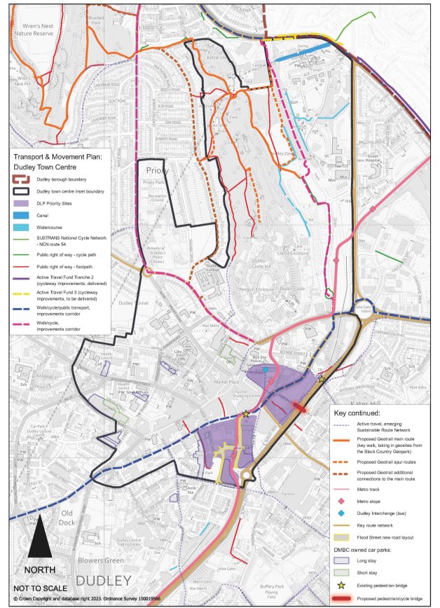
Policy DLPD8 Sustainable Transport and Active Travel in Dudley Town Centre
- Key schemes and priorities for sustainable transport improvements within Dudley town centre are identified on the Dudley Town Transport and Movement Plan and Policies Map. Development proposals within the town centre should ensure alignment with these schemes and provide connections to them to ensure opportunities for sustainable and active travel are maximised. Key schemes and priorities within the Inset Plan area are:
- New Interchange.
- Metro route and associated active travel improvements (including additional cycleways as detailed below).
- New cycleway links including along the A4123 (Priory Road to Tipton Road), the A4168 (A4123 south towards A459) and related to completion of the National Cycle Network route 54 through Dudley town (from A4123, via Trindle Road, King Street and Queens Cross).
- Regard should be had to active travel links beyond the town centre Inset Plan area, including proposed cycle routes along the A461 (from Dudley Port via Burnt Tree).
Justification
2.67 Dudley is a significant centre in the Black Country for a range of leisure, tourism and employment opportunities but further growth requires improvements to public transport, cycling and walking networks whilst facilitating opportunities for emerging innovations i.e., micro-mobility (small vehicles such as electric scooters).
2.68 The existing Dudley bus station is due to be redeveloped to provide a modern transport interchange, aligned to the forthcoming Metro line and stops. This is conveniently located adjoining the Town Centre Core Area alongside Fisher Street and its redevelopment will improve customer experience, improve operational efficiency, and provide a high quality, modern gateway into Dudley Town Centre. It is expected to be completed by Spring 2025.
2.69 Given that Dudley Town Centre has no direct access to the national rail network (with Dudley Port Station being approximately 2 miles away) the forthcoming Metro will have a key role in enhancing the accessibility for people travelling to and from Dudley Town Centre. In Dudley borough, the proposed Metro line provides a link from Castle Hill up into the Town Centre, adjacent to the bus station. The route then continues at street level along King Street and down Flood Street, and then continues west towards Brierley Hill. The Metro will also provide the borough with a connection to the national rail network at Wednesbury.
2.70 The Metro is under construction, with parts of the scheme at Castle Hill and Flood Street well under way and near completion. It is expected that passenger services will commence at the end of 2024.
2.71 There is a need to continue to safeguard the route as it remains under development and to enable future development sites within the town centre to reflect and complement the new Metro line, supporting economic regeneration and growth.
2.72 Effective management of the Key Route Network (KRN) and its links to the Strategic Road Network (SRN) are integral in supporting increased investment and regeneration in and around Dudley Town Centre. Maintaining and improving the efficiency of the local road network will benefit commuters, visitors and public transport users by reducing congestion and providing more reliable journey times into and out of Dudley. Major Network Scheme improvements, including those to Burnt Tree junction are part of this management.
2.73 The potential introduction of a 20mph zone covering the retail core of the Town Centre would align with national policy which places vulnerable road users at the top of the hierarchy by providing safer and enhanced environments for pedestrians. Furthermore, complementary traffic management measures, including improved pedestrian crossing facilities along primary thoroughfares would be incorporated into this 20mph zone scheme.
2.74 Dudley Town Centre sits alongside the Sustrans National Cycle Network (NCN) Route 54 (Derby to Stourport), which links to Brierley Hill and Stourbridge to the southwest and NCN Route 81 (Aberystwyth to West Bromwich) to the northeast. NCN 81 links to both Coseley and Wolverhampton to the north and Birmingham to the south. In the Dudley central area the route of NCN54 is not currently well established, and it is therefore proposed to consider the most suitable route that will both clearly define the route of the NCN and also provide good access directly into the Town Centre. As part of the active travel improvements at Trindle Road and the A461, cycleway links will be improved between the town centre and Castlegate Park.
2.75 Essentially a 'hub and spoke' ethos will be developed in Dudley Town Centre where placemaking efforts will be supported by a network of sustainable transport links to the Key Route Network (KRN), the Strategic Road Network (SRN) and the National Rail Network whilst also promoting accessibility to other local centres to raise Dudley's offer to its businesses, residents and visitors.
Figure 2.5: Dudley Town Transport and Movement Plan

Dudley Town Inset Plan Area Site Allocations
2.76 Dudley Town Inset Plan area contains two of the Borough's 'Priority Sites' at Flood Street/King Street and Trindle Road/Hall Street/Birdcage Walk (also known as 'Portersfield'). In addition, four 'Opportunity Sites' have been identified where redevelopment and regeneration would provide benefits to the town centre. These represent mixed use sites, including residential development. The opportunity sites do not preclude or diminish the importance of investment or change elsewhere within the centre. They simply reflect the Council's wish to prioritise use of its resources to kick start and progress projects which will have a significant impact and act as a catalyst for wider change.
2.77 In addition, there are several sites identified for residential development within the Inset Plan area. These are identified within Policy DLP10 as part of the overall housing land supply as summarised below.

