Part Two: Centres and Site Allocations (Regulation 18)
10. Biodiversity Net Gain (BNG) Offsetting Sites
Table 10.1: Biodiversity Net Gain (BNG) Offsetting Sites
Site Name
Gross Site Area (Ha)
Ward
Further Info
Alder Coppice
8.88
Sedgley
Council owned site
Site Name
Gross Site Area (Ha)
Ward
Further Info
Barrow Hill and Coopers Bank
76.26
Gornal
Council owned site
Site Name
Gross Site Area (Ha)
Ward
Further Info
Beacon Hill Quarry
3.54
Sedgley
Council owned site
Site Name
Gross Site Area (Ha)
Ward
Further Info
Bob's Coppice
9.55
Quarry Bank and Dudley Wood
Council owned site
Site Name
Gross Site Area (Ha)
Ward
Further Info
Buckpool and The Leys
47.74
Brockmoor and Pensnett / Wordsley
Council owned site
Site Name
Gross Site Area (Ha)
Ward
Further Info
Bumble Hole Nature Reserve
11.37
Netherton, Woodside and St Andrews and St Thomas's
Council owned site
Site Name
Gross Site Area (Ha)
Ward
Further Info
Caslon Wood
4.51
Cradley and Wollescote
Council owned site
Site Name
Gross Site Area (Ha)
Ward
Further Info
Coombeswood Wedge
12.1
Halesowen North
Council owned site
Site Name
Gross Site Area (Ha)
Ward
Further Info
Cotwall End and Turner's Hill
56.52
Gornal/Sedgley
Council owned site
(1) Site Ref: DLP BNG010
Site Name
Gross Site Area (Ha)
Ward
Further Info
Fens Pool
50.26
Brockmoor and Pensnett
Council owned site
Site Name
Gross Site Area (Ha)
Ward
Further Info
Ham Dingle
4.64
Pedmore and Stourbridge East
Council owned site
Site Name
Gross Site Area (Ha)
Ward
Further Info
Hawne Park
4.65
Belle Vale
Council owned site
Site Name
Gross Site Area (Ha)
Ward
Further Info
Meers Coppice
3.23
Quarry Bank and Dudley Wood
Council owned site
Site Name
Gross Site Area (Ha)
Ward
Further Info
Norton Crescent
6.12
Norton
Council owned site
Site Name
Gross Site Area (Ha)
Ward
Further Info
Saltwells Nature Reserve
109.03
Netherton, Woodside and St Andrews and St Thomas's/Quarry Bank and Dudley Wood
Council owned site
Site Name
Gross Site Area (Ha)
Ward
Further Info
Stambermill
5.43
Lye and Stourbridge North
Council owned site
Site Name
Gross Site Area (Ha)
Ward
Further Info
Swan Brook Valley
12.12
Upper Gornal and Woodsetton
Council owned site
Site Name
Gross Site Area (Ha)
Ward
Further Info
The Leasowes
65.01
Halesowen South
Council owned site
Site Name
Gross Site Area (Ha)
Ward
Further Info
Turls Hill
45.33
Sedgley/Upper Gornal and Woodsetton
Council owned site
Site Name
Gross Site Area (Ha)
Ward
Further Info
Wollescote Dingle
3.53
Cradley and Wollescote/Pedmore and Stourbridge East
Council owned site
Site Name
Gross Site Area (Ha)
Ward
Further Info
Wrens Next Nature Reserve
60.02
Castle and Priory/Upper Gornal and Woodsetton
Council owned site
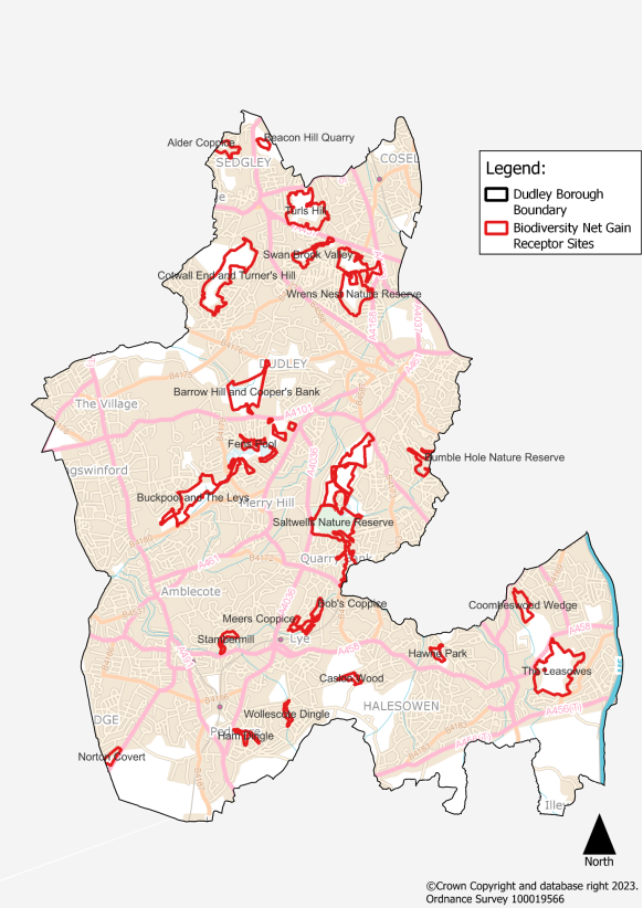
10.1 This list is indicative and subject to change and may be refined subject to further survey/baseline assessment work for Regulation 19 of the DLP
10.2 The DLP requires development to identify and incorporate BNG in line with Policy DLP32. Biodiversity net gain should be measurable as demonstrated by the latest DEFRA Metric.
10.3 Delivery is expected within the development site in the first instance. Where this cannot be achieved on site, developers may purchase credits for a BNG offsetting site. The list of sites in table 10.1 are sites considered suitable for BNG offsetting in Dudley.
Figure 10.1 Biodiversity Net Gain (BNG) Offsetting Sites


