

Dudley Borough Local Plan Scoping Consultation Document
9. Developing options for the spatial strategy
What are the key considerations in developing the options?
The plan will need to consider what options there are for sustainable development within the borough over the plan period and decide upon a preferred final ‘spatial strategy’ for the amount, type and location of future development. The spatial strategy will need to consider the following:
a) the overall development needs of the borough (e.g., the needs for housing, employment and other commercial uses).
b) the extent to which these development needs can then be accommodated within the borough taking account of local considerations, such as land availability and environmental constraints. This gives the development requirement.
c) the distribution of development, which is where and how that development will take place e.g., the supporting infrastructure required.
This will be informed by the following:
a) National planning policy (and supporting guidance).
b) The Plan’s Vision and ‘measurable outcomes’ related to the Vision (reflecting local considerations).
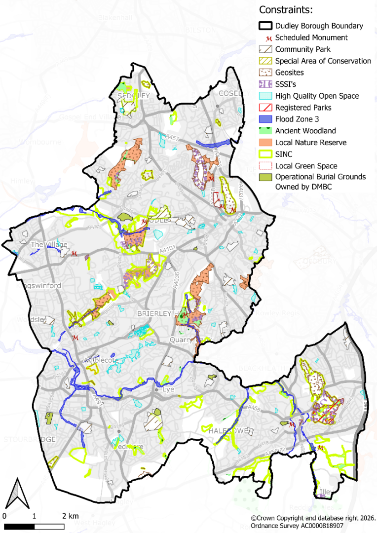
c) Local environmental constraints (affecting the suitability of land for development within the borough).
d) The availability and viability of land for development (including deliverability) taking account of local issues.
This section provides an overview of these factors and sets out how the Council intends to start developing the options for the spatial strategy. It takes account of the existing evidence base (including the Dudley Local Plan) and the changing national planning policy context. A key thread running through these is the need to ensure sustainable development in environmental, economic and social terms.
National planning policy and guidance: The key implications of the national planning policy context for potential high level spatial options for future development within the borough are considered in Appendix 2. Many of the implications remain the same between the extant 2024 NPPF and draft 2025 NPPF, however there are some differences in relation to Green Belt policy. National planning policy and guidance sets out the minimum local housing needs (according to the standard method for calculating local housing needs) which the Council must use. Other needs including those for gypsy and travellers, employment land and other commercial uses (such as retail) are established using locally produced evidence but drawing upon national policy and guidance for preparing these needs assessments.
Plan Vision: The Vision for the new Dudley Borough Local Plan will draw upon the Dudley Local Plan vision, updated as necessary to reflect changes to the national and local context, policy and guidance. Many elements of the existing Vision are still considered relevant to the new Local Plan. This includes the continued need to focus on regeneration and meet the borough’s development needs as far as possible whilst ensuring its unique natural and historic environment assets are protected, conserved and enhanced. The Vision and outcomes will also relate to matters such as the local housing needs of specific groups e.g., affordable housing and older persons housing, and the infrastructure necessary to support sustainable development. The range of topics covered by the Vision will need to be considered in the development of spatial options for future development.
Local environmental constraints (land suitability): The borough context is one of a largely urban authority that is relatively constrained by its existing built development up to the borough boundaries and surrounding urban areas. There are areas of undeveloped Green Belt and non-Green Belt land within, adjoining and outside the urban areas, however these are relatively limited. As noted in the baseline data section above, many are the subject of environmental designations (natural and historic) and/or serve important recreational purposes. This geographical context limits the spatial strategy options available for the new Local Plan i.e., a ‘new town’ is not an option for the borough.
Availability and viability of land (including deliverability): Based on the plan position and the new calculations for local housing needs outlined above, at this stage it is identified that the borough has a shortfall in its housing and employment land needs. Further development sites beyond that identified within the Dudley Local Plan will need to be considered in accordance with the most up to date national planning policy context. This will be informed by what land is ‘suitable’ (see above paragraph), ‘available’ i.e., willing landowners and/or developers, and the viability of land for development. It is recognised that the viability situation within the borough is challenging, particularly in specific areas of the borough and on brownfield sites. However, as part of the evidence base for the Dudley Local Plan it was recognised that the Council and its partners, such as the WMCA and Homes England, is working effectively to utilise regeneration funding to address such challenges. Related to viability is the overall deliverability of new development i.e., new development within the borough will need to be supported by the appropriate infrastructure.
What are the key steps for developing the options?
To develop spatial options for the borough, the Council considers that the following steps will need to be considered, in accordance with existing national planning policy and reflecting the local context (including the current position from the Dudley Local Plan). These steps are not necessarily sequential; they may be undertaken simultaneously to one degree or another.
The borough context is one of a predominately urban authority but with undeveloped areas of both non-Green Belt land (within the urban area) and Green Belt land (within and outside the urban area). As summarised in Appendix 2 national planning policy requires local authorities that contain Green Belt land to consider whether there are ‘exceptional circumstances’ for altering Green Belt boundaries (paragraph 146 of the NPPF, 2024). These circumstances include where an authority cannot meet its identified need for homes, commercial or other development through other means. Before concluding ‘exceptional circumstances’ exist, the Council should fully examine all other reasonable options for meeting its identified need for development (paragraph 147 of the NPPF, 2024). The plan strategy should:
- make as much use as possible of suitable brownfield sites and underutilised land;
- optimise the density of development; and
- be informed by discussions with neighbouring authorities about whether they could accommodate some of the identified development needs.
The steps outlined therefore reflect this current national planning policy position and the local context. A similar position is reflected in the draft NPPF (2025) albeit with some changes in respect of references to discussions with neighbouring authorities and consideration of land around railway stations. Any changes to the national planning position and its impact upon the drawing up of spatial options for the borough will need to be considered at the time of the updated NPPF.
In developing and assessing the spatial options, a key consideration will be the Local Plan Vision and measurable outcomes i.e., how does the option serve to deliver the overarching ambitions for the borough to ensure locally distinctiveness sustainable development.
Table 3: Key steps for developing the options
|
Key Steps |
Key Considerations alongside the Key Steps |
|---|---|
|
Step 1. Consider baseline position – land supply from the Dudley Local Plan) and the potential shortfall against updated development needs for the new Local Plan
|
|
|
Step 2. Explore the potential for additional supply from the existing urban area and brownfield land
|
|
|
Step 3. Engage with neighbouring and other relevant local authorities (part of shared housing and economic market areas) to understand the wider housing and employment land supply and shortfall considerations and implications for Dudley.
|
|
|
Step 4. Consider the potential for additional development sites outside the urban area to inform options for the spatial strategy
|
Figure 7: Map of Gateway Environmental Constraints
How will sites be assessed?
The new Local Plan will need to be informed by a site assessment process to determine which locations and sites represent the most appropriate and sustainable locations for future development.
The Council is currently reviewing its site assessment process for the new Dudley Borough Local Plan. This will draw upon the site assessment methodology used for the Dudley Local Plan but with any necessary amendments to account for national and local policy, guidance and context changes. Current government guidance on site assessment for the new plan-making process will be taken account of[12]. We would welcome your views on the site assessment process as part of this consultation, including what updates or amendments you consider may be required to the site assessment methodology.
Question 18. Do you agree with the key steps for developing the spatial options outlined at this stage?
Question 20. Do you agree that sites which are substantially affected by such constraints should be excluded from the spatial option and site selection process at this stage of plan-making? This would apply to the consideration of options and sites within and outside the existing urban area, and brownfield and greenfield land.
[12] MHCLG Guidance – Selecting sites for development
