Dudley Borough Local Plan Scoping Consultation Document
Ended on the 10th September 2026
6. Baseline data and key issues
The baseline data and key issues draw upon a range of existing sources, including other relevant corporate strategies (outlined in Section 1). We would welcome views on any other baseline data and key issues should be identified at this stage.
Borough context
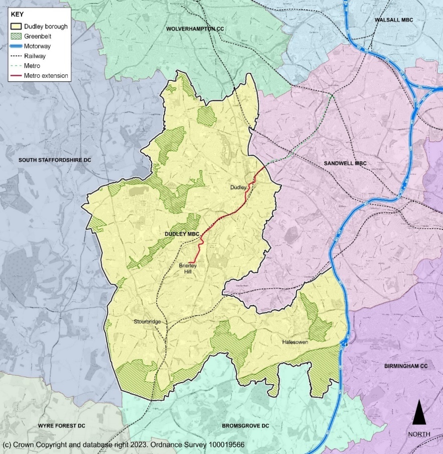
Dudley borough is a large metropolitan borough (98 square kilometres/38 square miles) located on the western part of the West Midlands conurbation at the heart of the Black Country. It shares an eastern boundary with the City of Birmingham and Sandwell MBC, and to the north with the City of Wolverhampton. To the west and south it is bounded by the districts of South Staffordshire, Wyre Forest and Bromsgrove and is within relatively close proximity to Shropshire. Its main towns are Brierley Hill, Dudley, Halesowen and Stourbridge.
The borough is predominantly urban in character but also contains extensive green space and natural assets- 18% of the borough is designated as Green Belt and 14% is categorised as publicly accessible open spaces. Dudley has a rich cultural and industrial heritage and is often referred to as the historic capital of the Black Country, a name derived from its industrial past of coal mines and blast furnaces used for iron and steelmaking.
Figure 5. Dudley MBC and neighbouring authorities
Existing Local Plan – key points
The Dudley Local Plan sets out the current spatial strategy for development. It identifies locations for future development and infrastructure investment and reflects areas of protection such as environmental designations.
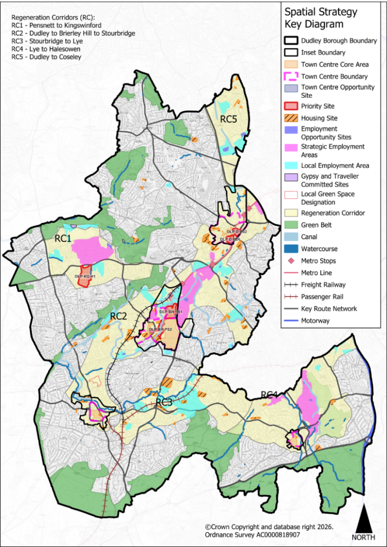
The strategy is based around five Regeneration Corridors within the urban area, which form the focus of future development, reflecting the borough’s regeneration needs and brownfield land capacity. Challenges associated with this regeneration are recognised, including the viability of development, however a range of intervention measures and funding mechanisms are identified to deliver the strategy.
In terms of the settlement hierarchy, there are the following:
1 Strategic Centre- Brierley Hill
3 Town Centres- Dudley, Halesowen, Stourbridge
3 District Centres- Kingswinford, Lye, Sedgley
15 Local Centres- Amblecote, Cradley/ Windmill Hill, Gornal Wood, Hawne, Netherton, Oldswinford, Pensnett, Quarry Bank, Roseville, Shell Corner, The Stag, Upper Gornal, Wall Heath, Wollaston, Wordsley.
Brierley Hill and the 3 town centres offer a wider range of facilities to a wider than local catchment area, whilst the district and local centres serve more day-to-day neighbourhood needs. The existing urban area is generally physically accessible to services such as primary schools and healthcare; however, it is recognised that the capacity of services requires further consideration as part of infrastructure planning and investment.
Figure 6. Dudley Local Plan Spatial Strategy
Table 1: Dudley Borough – baseline data
Topic
Key baseline data
Key Issues arising
Population
The borough is home to 323,488 people (2021 Census, note that 2024 estimates indicate the population to be 331,930 people).
Between the censuses held in 2011 and 2021, the population of Dudley increased by 3.4%. This represents a smaller percentage than the overall population of the West Midlands (up 6.2%), and a smaller percentage than the overall population of England (up 6.6%).
In 2021, Dudley was home to around 23.6 people per football pitch-sized piece of land, compared with 22.8 in 2011. It is among the top 20% most densely populated English local authority areas.
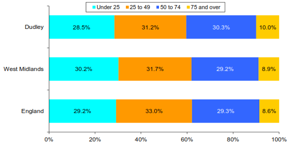
Based on the 2021 census, the borough has a similar age structure to England with around 23% young people aged 0-19. However, Dudley’s age profile differs from that of the West Midlands and England whereby Dudley has a lower population age profile of 10–24-year-olds than the West Midlands and England but has a greater population age profile of people aged 50 – 85+.
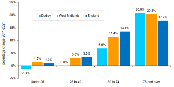
Between the 2011 and 2021 census, the number of people aged 50 to 64 years rose by around 6,800 (an increase of 11.9%), while the number of residents between 35 and 49 years fell by around 7,700 (11.4% decrease). The number of people aged 75 and over grew by over 20%.
Based on the 2024 population estimates, there are 59,216 young people under aged 15 and 67,075 older persons aged 65 and over.
Population projections based on the 2022 estimates - the latest projections available - predict that the population of Dudley Borough will increase to around 347,600 by 2045, an increase of 4.7% from the 2024 figure. Those aged 30 to 50 and over 65 are expected to undergo the largest increase in numbers over the time period, with the largest increases in those aged 60 and over.
Population composition in Dudley by age groups- 2021 census (reproduced from Dudley SHMA, 2024)
Change in number of people in each age band between 2011 to 2021 census (reproduced from Dudley SHMA, 2024)
The profile of Dudley’s population mirrors that of the West Midlands and England with 50.8% of the population being female and 49.2% being male.
Based on the 2021 census 84.9% of borough’s population is of white British origin in comparison to 77% for the West Midlands and 81% for England. Asian ethnic groups constitute 8.4% of the overall population in the borough in comparison to 13.3% for the West Midlands and 9.6% for England. 2.8% of the population are from mixed ethnic groups in comparison to 3% for both West Midlands and England. 2.5% of the population are from Black ethnic groups in comparison to 4.5% for West Midlands and 4.2% for England. A further 1.4% of the population are from other ethnic groups.
Low population growth overall. Whilst there is a pattern of an ageing population at the regional and national level, it is more pronounced in Dudley.
The borough represents a relatively densely populated urban area, which gives rise to a specific local opportunities and constraints e.g., relatively good access to services, but also congestion issues.
The ethnicity of the population is relatively less diverse, but a range of different ethnicities are still represented.
Housing
Housing need is currently 1,514 dwellings per annum, totalling 22,710 dwellings over a typical 15-year plan period.[8] The Dudley Local Plan identifies housing supply of 643 dwellings per annum, totalling 10,937 dwellings for 2024-2041. The Council is required to use the standard method for calculating local housing needs as per national policy and guidance.
Affordability: current affordability ratio (house prices versus earnings) is 6.8 (May 2025) with anything over 4 indicating an affordability adjustment is required to overall housing needs i.e., average house prices in Dudley are 6.8 times average earnings. This has varied in recent years (increased from 6.2 in 2018 and 6.5 in 2024 but in line with 6.8 in 2022 and 2023). It compares to a West Midlands average of 6.9 in 2024.
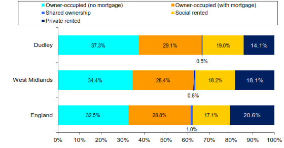
As of 2021, there was a greater proportion of households in owner-occupied houses (with and without a mortgage) in Dudley compared to the West Midlands and England proportions. The social rented sector was also slightly higher, with the private rented sector representing a relatively lower proportion. Between 2011 and 2021 the increase in the percentage of privately rented homes was greater in Dudley than across the West Midlands and England, however the overall proportion remains below the West Midlands and England levels. There was a decrease in the percentage of owner-occupied homes, however the overall proportion remains above the West Midlands and England levels.
Tenure profile in Dudley, West Midlands and England, 2021 (reproduced from Dudley SHMA, 2024)
The 2021 Census indicates that there were 140,286 dwellings in Dudley in 2021. The number of dwellings in the Borough grew by 4.8% between 2011 and 2021 (some 6,378 dwellings). This growth is lower than that recorded regionally (the number of dwellings grew by 7.3% across the West Midlands between 2011 and 2021), and nationally (growth in dwellings of 8.5% over the same time period).
There is an established gypsy, traveller and travelling showpeople population within the borough, the specific housing needs of which need to be accommodated.
Substantial increase in housing needs. Need to consider implications for local housing market, including deliverability. The HMA (2024) stated that in relation to the 2024 housing need ‘a notable additional increase in in-migration to the Borough would be required to generate these additional households.’
Substantial shortfall in housing supply identified when applying the new standard method for calculating local housing needs (circa 12,000 dwellings shortfall for a 15-year plan period).
Affordability of housing requires an adjustment to the baseline local housing needs (this is done via the standard method for calculating local housing needs), but the comparably the borough is not as unaffordable as some areas within the region.
The housing needs of specific groups will need to be considered and met as far as possible, including affordable housing, older persons housing, gypsy and traveller and travelling showpeople accommodation.
Economy and Employment (including the town centres)
The Dudley Local Plan identifies a requirement of 73.5 – 92.1ha of employment land (2024-2041) and supply of 12.5ha. Potential additional supply from 14ha at West Midlands Interchange and an employment land surplus of 42ha (both within South Staffordshire, with the latter for the whole of the Black Country).
Of the required 73.5ha it is estimated that 23.50ha is required for manufacturing (B2) and 49.94ha for Storage and Distribution (B8).
The structure of the local economy has shifted with the restructuring of the manufacturing sector over the previous decades, and the borough economy is now more service-based. The manufacturing sector is still important with 12.3% of jobs in manufacturing, compared to 9.6% in the West Midlands and 7.3% in Great Britain (2024). There are also comparatively higher levels of employment in the Wholesale and Retail Trade and Health and Social Work sectors.
The borough contains several visitor attractions including Dudley Zoo and Castle, Black Country Living Museum, Dudley Canal & Caverns, Himley Hall and Park, the Stourbridge Glass Quarter, and the Dudley Museum at the Archives. There were 9.6 million visits to the borough of Dudley in 2024, contributing £447 million to the visitor economy of the borough.
There is a relatively higher proportion of workers in lower skilled occupations and a lower proportion of residents in more senior professions compared to regional and national averages. This aligns with the qualifications profile of the borough.
The job density of the borough is 0.6, compared to 0.79 in the West Midlands and 0.85 in Great Britain (2024).
Total Gross Value Added (GVA)[9] increased from £5.9bn (2022) to £6.2bn (2023) but the growth rate of 4.9% was below the England national rate of 9.1%. There is an overall GVA output gap[10] of £5.8bn. The GVA per head is £18,838 which is substantially below the national England average of £36,632 (2023).
Employment rate: 75.1%. This is the highest in the Black Country (July 2024-June 2025)
The average full-time resident earnings for Dudley in 2025 were £35,486,an annual increase of 2.0% compared to an increase of 4.3% nationally. Earnings were approximately 90.4% of the England average (£39,243).
The 2025 Centre Health Checks shows that the average vacancy rate within the designated Town Centres is 15.2% of units, this is slightly lower for District Centres with a vacancy rate of 11.7% and 8.8% vacancy rate for Local Centres.
Current shortfall in employment land supply of circa 61 – 80ha with the Dudley Local Plan.
Reliance on neighbouring authorities to meet employment land needs, namely South Staffordshire.
The local economy has diversified in recent years, but still reliant on lower skilled occupations.
Relatively lower job density indicates higher levels of out-commuting for employment.
Economic growth is slower than national, widening productivity gap.
Lower wages and productivity constrain living standards.
Natural Environment
The borough is home to a range of nationally and locally designated natural environment assets including 10 Sites of Special Scientific Interest (SSSI), 2 National Nature Reserves (NNR at Wrens Nest and Saltwells), 7 Local Nature Reserves (LNR) and over 200 Local Sites (SINCs and SLINCS) across the borough.
The Black Country is a UNESCO Global Geopark due to its internationally important geology. 16 of the 45 ‘Geosites’ are located within Dudley borough.
The borough is covered under the West Midlands Local Nature Recovery Strategy (LNRS) published in 2025. LNRSs are legally required spatial plans focused on nature recovery and environmental enhancement. Each strategy sets out agreed priorities for restoring nature, identifies key existing areas of ecological value, and outlines specific opportunities to create or improve habitats—supporting wider environmental objectives through nature-based solutions.
Protect and enhance the natural environment by safeguarding important habitats is protected and enhanced in line with national policy.
Natural environment links to visitor economy and potential for regeneration (subject to no harm to the value of assets themselves).
Use the LNRS to identify local ecological networks and opportunities for nature recovery through new development, such as improving ecological connectivity and creating new habitats.
Climate change and other environmental issues?
The Council declared a climate emergency in July 2020 and pledged to achieve carbon net zero by 2030 and a carbon net zero Borough by 2041.
The borough is an Air Quality Management Area (alongside the 3 other Black Country boroughs).
The most significant sources of flood risk in the borough are fluvial and surface water flooding. The primary fluvial flood risk lies along the river Stour and its tributaries.
Improve the use of energy‑efficient technologies in all new development and support the retrofitting of existing buildings
Reduce carbon emissions through sustainable construction methods and by improving the long-term energy performance of buildings
Ensure developments incorporate measures to mitigate and adapt to the impacts of climate change
Historic Environment
The borough is home to a range of nationally and locally designated historic environment assets including 2 Registered Parks and Gardens (The Leasowes and Priory Park), 10 Scheduled Monuments, 22 Conservation Areas and around 300 Statutory Listed Buildings. There are also just under 300 buildings on Dudley’s ‘Local List’ (locally important historic buildings).
There are 13 canals (25.3km) including listed assets, aqueducts, bridges and locks.
Need to ensure the historic environment is conserved and enhanced in line with national policy and legislation.
Historic environment links to visitor economy and potential for regeneration (subject to no harms to the value of assets themselves).
Transport
Access to the strategic road network, including the M5 motorway links near Dudley and Halesowen.
An existing trainline connects Stourbridge to Birmingham and a new Metro line will connect Wednesbury-Dudley-Brierley Hill. Phase One will link Dudley (passenger services due to start by end of 2026) and Phase Two will link Brierley Hill (early construction works underway). An associated new transport Interchange (for the Metro and bus services) is under construction in Dudley town centre.
63.9% of the borough’s residents in employment travel to work by car (above the West Midlands and England levels), 5.6% walk, 4.2% take a bus and 1.4% a train or tram. 21.7% work mainly from home. As these figures were recorded by the 2021 Census (during the Covid pandemic) is it expected that some of these trends may have altered.
There is a continued dependency upon car travel. Improvements to the borough’s sustainable transport network are however ongoing and are expected to improve the borough’s connectivity to the wider sub-region.
Education and skills
As of August 2024, there were 201 providers of early years education including 85 childminders, 105 pre-school/nurseries, and 11 home child carers or childcare on domestic premises, providing some 4,739 early years places. The Council’s Childcare Sufficiency Assessment (2024) suggests that at this stage there are no issues being flagged up to suggest there are shortages in the number of providers and overall provision. If sufficiency is identified as an issue in the foreseeable future, there are new providers who are currently pending Ofsted registration.
RQF Level 4+ (equivalent to the first year of a bachelor’s degree, HNC, or high-level apprenticeship): 41% of the Dudley population are qualified to this level compared to 44% in the West Midlands and 49% in Great Britain (2025)
No qualifications: 7% of the Dudley population compared to 8% in the West Midlands and 6% in Great Britain (2025).
The proportion of those aged 16-17 Not in Employment, Education or Training (NEET) is 21.5%, which is significantly above the national England average of 5.6%.
61% of Dudley pupils are meeting the expected standard at Key Stage 2 compared to 62% for England (2025).
The number qualified to at least NVQ4 (degree level) grew from 39,000 to 67,000 between 2004 and 2021, an increase of over 74%. This is partly the result of substantial investment into the skills infrastructure, including the ongoing expansion of Dudley College of Technology.
Further investment has been made in the borough for both further and higher education facilities, including the opening of the Black Country and Marches Institute of Technology (in collaboration with the Universities of Wolverhampton and Worcester) and the Health Innovation Centre in Dudley (a collaboration between Dudley College and the University of Worcester)
Across the borough there are 78 primary schools (of which 38 are primary academies) for 4–11-year-olds.
Secondary school provision across the borough is 19 schools of which 15 are secondary academies providing for Years 7 to 11. Some schools do make provision for years 13-14 which is discussed separately as post 16 education provision.
As with many other local authorities across the country, Dudley experienced a bulge in birth rates peaking in 2011/12 followed by a steady decline in the birth rate (Figure 1). In turn the mainstream primary school reception intakes rose and peaked in the academic year 2016/17. School expansion projects were undertaken across the borough to ensure sufficiently of places to accommodate this growth in numbers.
Skills shortages limit productivity and business growth
Rising numbers with no qualifications increase exclusion
Extremely high NEET levels risk long-term disengagement
Health and Social Wellbeing
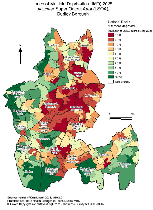
In 2025 Dudley ranked 115th most deprived of 296 local authorities.
The 9th most deprived local authority in the West Midlands region.
Parts of the borough are more deprived than others with particular challenges around Dudley, Pensnett, Netherton and Brierley Hill, but also parts of Coseley, Lye, Halesowen and Stourbridge. 27.9% of the Dudley population live in areas amongst the 20% most deprived in England (those areas outlined above) whilst 22.5% live in areas amongst the 20% least deprived in England.
Average life expectancy for men is 78.9 years (79.5 years for England) and 83 years for women (83.3 years for England). Life expectancy for men in the most deprived areas of Dudley is 10.1 years lower than in the least deprived areas, and 7.4 years lower for women (based on 3 year period 2021-23).
The 2021 census recorded 19.3% of the population as disabled under the Equality Act in 2021, higher than the regional and national averages.
Economic inactivity (people not working due to specific reasons) is close to 20%, driven by long-term sickness.
15.8% of households are in fuel poverty. Across all local areas in England, this was the 15th highest, moving from 21st place in 2022. The West Midlands region continues to have the highest rates at 16.7%, compared to 11.4% overall for England in 2023.
43.2% of children are in income-deprived families, ranking the borough 51st highest in England for this measure.
Dudley also has higher rates of hospital admissions for alcohol compared to the England average. Many users of adult social care say they feel isolated and experience poor health-related quality of life.
Dudley Council and its partners, including other healthcare infrastructure providers, have a critical role to play in delivering high-quality Dudley has higher rates of physically inactive adults and children and higher rates of obesity than those for England as well as lower rates of the population eating 'five a day' and a higher number of fast-food outlets per 100,000 population. High concentrations of Hot Food Takeaways.
Dudley is the safest borough within the West Midlands Police Force area with the lowest crime rate per 1000 population.
Poor health is a major barrier to employment
High deprivation increases pressure on services
Need for integrated health, skills and employment support
Question 12. Is there any other baseline data the Council should be considering?
Question 13. Are there any other key issues that should be considered?
[8] Local housing need (LHN) as of May 2026, using March 2026 affordability data and May 2026 housing stock data (applying the 2024 standard method for calculating local housing needs).
[9] GVA measures the value of goods and services produced in an area, industry, or sector of an economy. is defined as the value of the goods and services produced minus the value of the inputs that were used to produce those goods and services. GVA is a key indicator for regional economic performance.
[10] Output gap measures the difference between an economy's actual GVA and its maximum potential GVA.
For instructions on how to use the system and make comments, please see our help guide.