

Dudley Borough Local Plan Scoping Consultation Document
2. Spatial Development Strategies and sub-regional context
What are Spatial Development Strategies?
Alongside the new local plan making system, the Planning and Infrastructure Act (2025) introduced a new tier of plan-making, known as ‘Spatial Development Strategies’ (SDSs). These SDSs represent sub-regional strategic plans that sit above individual local authority local plans, and their geography will vary across the country. They will form part of the formal development plan for areas, used to inform overarching development strategies and determining planning applications.
In respect of the role SDSs are expected to play, the Government view is that housing need (and related matters) cannot be met without planning for growth on a larger than local scale i.e., individual local authority plans seeking to address cross-boundary needs via cooperation alone are not sufficient. SDSs have been introduced to provide a new mechanism for cross-boundary strategic planning. They are intended to replace the former ‘Duty to Cooperate’ which placed a legal duty on individual plan-making authorities to cooperate on strategic planning matters; however, the ‘Duty’ was deemed to be ineffective in practice.
SDSs are intended to play a vital role in delivering sustainable growth and addressing key spatial issues including meeting housing needs, delivering strategic infrastructure, growing the economy, and improving climate resilience. Whilst the precise scope and detail of SDSs is still emerging via further national legislation, policy and guidance, a key principle is that SDSs will set the overall direction and strategy for their area, including strategic policies. Local planning authorities will then produce local plans with local policies and site allocations.
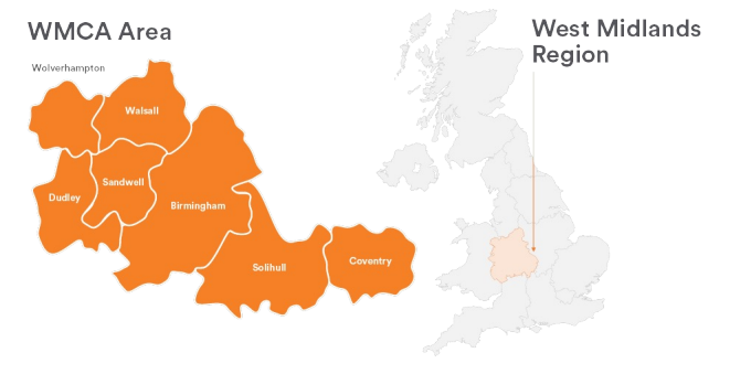
The new Local Plan for Dudley must be in general conformity with the relevant SDS for the borough. Dudley Council is a constituent member of the West Midlands Combined Authority (WMCA) which is the relevant body for preparing a SDS for the WMCA geographical area. The WMCA SDS area comprises of the four Black Country Authorities (Dudley, Sandwell, Wolverhampton and Walsall), Birmingham, Coventry and Solihull (the 7 constituent members). The non-constituent members of the WMCA, are not subject to the SDS coverage.
Figure 1. SDS area based on WMCA constituent members
The SDS for the WMCA area is in the early stages of preparation with initial public and stakeholder engagement and evidence base gathering taking place over 2025-2026[5]. The SDS will support the delivery of the WMCA Growth Plan[6] from a planning perspective, reflecting the range of plans and programmes that also support the Growth Plan including the Place Based Strategies developed by constituent authorities as part of the Integrated Settlement[7]. Other sub-regional plans such as the West Midlands Transport Plan and the West Midlands Local Nature Recovery Network Strategy will also inform the SDS. The provisional SDS timetable is available to view here.
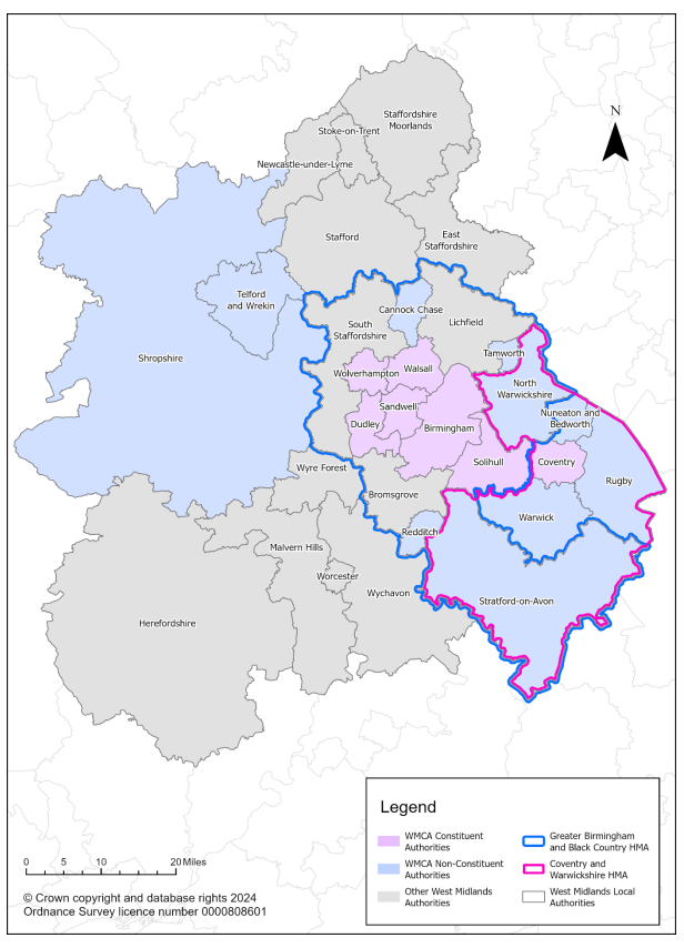
The SDS for the WMCA will need to have regard to relationships with neighbouring SDSs that are being prepared, particularly given the wider housing and economic market relationships that have been identified between the WMCA area and its neighbours previously. For example, previous local plan work on housing market relationships across the sub-region has identified the Greater Birmingham and Black Country Housing Market Area (GBBCHMA), which covers 14 local authorities, many of which are not covered by the WMCA SDS geography. In addition, Coventry City Council (covered by the WMCA SDS area) lies outside of this GBBCHMA, and has been previously identified as part of the adjoining Coventry and Warwickshire Housing Market Area (CWHMA).
Figure 2. GBBCHMA, CWHMA and the WMCA overlay
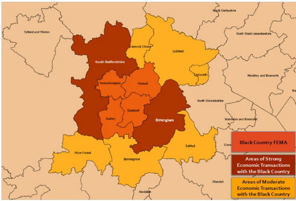
In terms of economic market relationships, a strong link between the Black Country authorities and neighbouring authorities such as South Staffordshire has also been previously identified.
Figure 3. Black Country FEMA and its relationships
How will the Council ensure effective cooperation with other relevant bodies?
Alongside the SDS taking account of neighbouring SDSs, the new Dudley Borough Local Plan will need to demonstrate it has had regard to individual neighbouring and other relevant local authorities’ local plans via effective cooperation. Cooperation with key public bodies such as Natural England, the Environment Agency and Historic England should also be demonstrated. The former legal and soundness test of the ‘Duty to Cooperate’ was abolished in March 2026. This placed a duty on local authorities and public bodies to engage constructively on strategic and cross-boundary planning matters.
Whilst the duty has been abolished, the need for effective cooperation is mandated by the NPPF (2024, paragraphs 24-28) and is part of the tests of soundness for local plans (under plans being ‘positively prepared’ and ‘effective’- see paragraph 36 of the NPPF, 2024). Strategic matters have previously included:
- housing and employment needs (including gypsies, travellers and travelling showpeople)
- infrastructure (for example relating to health, education and transport)
- environmental issues (such as effects on air quality and designated nature conservation sites)
- waste and minerals.
Within the wider sub-regional context, there is the ongoing process of Local Government Reorganisation (LGR) which will change the political and plan making geographies of the borough’s neighbouring local authorities e.g., the reorganisation of existing two-tier systems in neighbouring Staffordshire and Worcestershire and in nearby Warwickshire. The Council will need to remain aware of this changing picture of plan-making geographies and any implications for the preparation of the new Borough Dudley Local Plan.
