
Dudley Local Plan Part Two
Introduction
3.1This chapter outlines how Stourbridge Town Centre will develop and change over the plan period and sets out a vision for the town centre, which will be delivered through the Local Plan policies and site allocations (up to 2041). This chapter elaborates on the policies set out in Part One of the Dudley Local Plan by providing specific policies relevant to Stourbridge Town Centre. This chapter should be read primarily in conjunction with Chapter 10 (Centres and Town Centre Uses) within Part One, along with other relevant Part One policies as applicable to individual proposals.
3.2Stourbridge, on Dudley Borough’s south-west fringe, is a popular and attractive Town Centre close to open countryside, including the Clent Hills and Kinver Edge. With a compact and easily accessible Town Centre, it offers a pleasant shopping environment in the High Street and the Ryemarket shopping centre. The town is home to many smaller, specialist shops.
3.3Stourbridge still retains many of its later medieval market town features which contribute to its unique character. Lower High Street housed the market which gained its charter around 1482 and the Town Hall was built in 1887 to mark Queen Victoria’s Golden Jubilee. Students have been educated at King Edward VI College since 1430, and the present buildings date back to 1861. The Foster and Rastrick Iron Foundry (now Lion Medical Health) and the Bonded Warehouse, Canal Company Offices and Weighbridge in Canal Street are reminders of the industrial significance of the town throughout the 18th and 19th century. Stourbridge has been home to the world’s finest glass designers and makers since the 17th century forming part of the well-established Glass Quarter and today it still boasts the highest concentration of artists in the Dudley Borough.
3.4This chapter aims to make the most of Stourbridge’s valued and distinctive local character and further improve its vibrancy, attractiveness, and economic health.
The Stourbridge Inset Plan Boundary
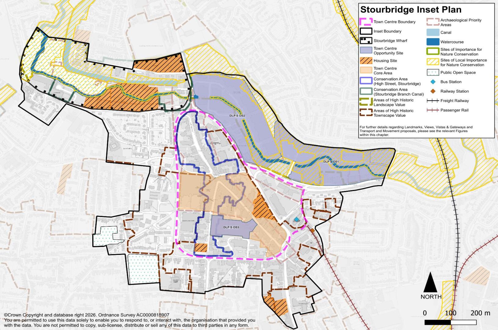
3.5 This inset chapter covers Stourbridge Town Centre, including its conservation area and also encompasses the Stourbridge Wharf and wider Canal Wharf, also designated as a Conservation Area. The Stourbridge Town Centre Boundary and Stourbridge Town Centre Core Area boundary are identified on the Stourbridge Inset Policies Map.
Vision and Objectives
“By 2041, Stourbridge will be a vibrant and inclusive town with a thriving and prosperous Town Centre, which offers a wide range of shops and services, including exceptional leisure facilities and a varied evening and entertainment economy. Stourbridge will retain its unique market town character whilst embracing the arts and creative industries. It will offer excellent cultural facilities and sustainable urban living, utilising the riverside and canal-side settings.
Connectivity to the town centre will continue to be improved, creating a network of safe and attractive routes across the ring road for pedestrians and cyclists. A high-quality built environment and public realm will be created which will preserve and enhance the historic character and local distinctiveness of Stourbridge.”
The following specific objectives for Stourbridge have been identified –
- To provide, protect and enhance a well-connected setting of streets, other routes, and green and public spaces that are attractive, lively, pleasant to use, safe and secure.
- To continue to increase the awareness, visibility and ‘rediscovery’ of the River Stour, returning it to a more natural state and providing continuous footpath and cycleway linkages along its length. Green wildlife corridors will be encouraged to improve the nature conservation value of the watercourse.
- To protect and enhance the locally distinctive character of Stourbridge with reference to its historic environment and cultural and built heritage.
- To facilitate and shape housing-led regeneration on the Opportunity Sites, focused on the River Stour and Stourbridge Branch Canal – ensuring the delivery of homes which meet the needs of the local community.
- To provide a network of well-connected and direct pathways and spaces for pedestrians and cyclists, and to reduce the severance effect of the ring road by providing enhanced permeability to the Town Centre.
- Create a liveable town centre that prioritises people, supports local retailers and services, and encourages walking, cycling, and public transportation while reducing through-traffic.
Policies
Stourbridge Town Centre and Town Centre Core Area
3.6In line with national and local planning policy, and developments for new main town centre uses will be directed towards the Town Centre and Town Centre Core Areas, as appropriate. The diversification and repurposing of Stourbridge Town Centre will be supported by approving development which enhances the viability and vitality of the centre. This is subject to the proposed use being appropriate to its location within the town centre and in accordance with Policy DLP24, which sets out the strategic approach to town centre development within the Borough, including appropriate uses. This section provides specific information relevant to Stourbridge Town Centre for context, but no additional policy provisions to Policy DLP24 are set out other than in site specific allocations.
3.7The Stourbridge Town Centre boundary comprises the area within the ring road, and the area of land between the ring road and Birmingham Street, identified as Angel Passage.
3.8The town centre will remain an important focus for day-to-day shopping and a range of other town centre uses such as office, leisure, and cultural facilities. As recognised in the Local Plan, in view of the changing nature of town centres, there is a need to diversify in terms of uses that promote and encourage their vitality and viability. The recent changes to the Use Class Order (wherein retail uses now lie within the same ‘E’ Use Class as other uses, including food and drink, or offices) mean that retail uses are now able to change more freely to other uses. Whilst this enables town centres to become more flexible and responsive to changes, it does mean it is now more difficult to manage the loss of retail uses.
3.9Notwithstanding the above, in line with national planning policy it remains important to identify the Town Centre Core Area (formerly Primary Shopping Area) for the key purpose of identifying whether a retail development proposal constitutes edge of or out of centre development. It is recognised that there is likely to be a diversification of uses within the Town Centre Core Area, however, any new proposals for retail development will still be directed towards it in the first instance.
3.10The provision of additional residential developments, particularly through the re-use of upper floors of premises will be supported, subject to Policy DLP28.
3.11The proposals for the individual opportunity sites reflect the overarching vision for the Town Centre, with preferred uses identified for each site (see Opportunity Site Policies).
Stourbridge Wharf
3.12Stourbridge Wharf is a ‘linchpin’ area between Stourbridge Town Centre and the existing and proposed housing led regeneration areas within the River Stour and Stourbridge Branch Canal corridor. It has been described as a historic community asset, contributing to the distinctive character of Stourbridge, and having a multi-functional role for the benefit of the local community and visitors.
Policy DLPS1 Stourbridge Wharf
- The Stourbridge Wharf area, shall be promoted as a focus for:
- Canal based uses and activities including additional visitor moorings
- Creative/cultural industry and visitor economy uses and complementary entertainment, and leisure uses
- Appropriately designed residential use. These will be sensitive to the existing and proposed residential uses, whist promoting the area’s unique heritage
- Development shall safeguard the operation viability of the Stourbridge Navigation Trust (SNT)
- Public realm improvements to include works to enhance the nature conservation value of the area and towpath improvements, including the formation of an expanded canal basin.
- Improvements shall be sensitive to heritage assets and be embedded within Green Infrastructure, which enhances existing wildlife habitats and uses locally distinct flora and includes the removal of invasive plan species.
- Improvements to the connectivity over the canal and river through the provision of new bridges connecting new residential developments with the wider area.
Justification
3.13The canal and the area to the north is designated as a Site of Local Importance for Nature Conservation (SLINC). Any proposed development for works should retain that vegetation which has nature conservation value and opportunities should be taken to enhance its value through development proposals or canalside enhancement works.
3.14The area is also a conservation area (The Canal Street Conservation Area), containing a Grade II Listed Building (The Bonded Warehouse) and four Locally Listed Buildings within a historic canal-side setting. The conservation area is currently included on Historic England’s Heritage at Risk Register. An opportunity exists to draw on this heritage, including promoting and enabling canal-based activities, uses, and tourism, to reinforce the character thereby sustaining and improving conservation area.
3.15Enhancing the current pedestrian and cycle linkages around the Canal and River Stour in the Stourbridge Wharf area is important to promote active travel and create linkages within the communities. It is therefore important that new developments within these areas, such as Bradley Road East and West incorporate the development of new bridges to provide access to the surrounding areas and provide connections for residents on both sides of the canal and rivers to access surrounding infrastructure including, the Public Open Space, Riverside House, War Memorial Athletic Ground and Lion Health. While also providing better connection to the wider pedestrian and cycle network.
3.16In areas where the activities of SNT are based to help safeguard the operational viability of SNT development should consider the provision of car parking to facilitate the holding of events and the formalisation of enclaves within these areas.
Design and Public Realm Design
3.17Local Plan Policy DLP39 provides the overarching context for considering design quality. Regard should also be had to policies for the historic environment (Local Plan Policy DLP54 – DLP58). This section sets out those characteristics of the most importance to the Stourbridge inset plan area and town centre specific policies.
3.18Stourbridge contains many buildings of historic and architectural quality and interest, as well as attractive views within and out from the Town Centre core.
Policy DLPS2 Urban Character and Appearance in Stourbridge
- All new development within the plan area shall:
- Respect and respond to the local distinctiveness and existing context of established built form, scale, and massing that presents the broad urban townscape of the Inset Plan area. This includes locally distinctive plot widths, building heights, building proportion, roofscapes, form, materials, distinctive style, and historical relationship of the pattern of building in its sense of enclosure of the streets on which it stands.
- Provide for, and take opportunities to, enhance active frontages at the interface between public and private spaces, in particular those fronting the ring road, River Stour and Stourbridge Branch Canal, reduce the physical and visual impact of vehicles and service areas, and enable a clear distinction between public and private spaces.
- The choice of which locally distinctive elements are incorporated into the design of a development, and the degree to which they are incorporated, depends upon the location of the proposal, and the function the building serves in the townscape as described by other Policies in this Plan.
- Developments can incorporate elements not described as ‘locally distinctive’ or be of a more contemporary style provided that the overall design of the development does not harm the achievement of a locally distinctive Town Centre.
Justification
3.19The Assets in Stourbridge Town Centre help to shape the character, identity and visual quality of the town and it is essential that developments in the area that both respond to and respect the existing character and context of Stourbridge Town Centre.
3.20Where the historic character of the built environment makes a positive contribution to local distinctiveness, this should be conserved and enhanced wherever possible. All new developments should respect and respond to the positive characteristics of the locality. This most up to date Historic Landscape Characteristic and evidence should be used in considering how new development proposals and the enhancement of existing townscapes and landscapes should respect the town’s character.
Policy DLPS3 Stourbridge Town Design - Landmarks, Views, Vistas and Gateways
- All new development should have regard to Policy DLP4, Policy DLP39 and Policy DLP54 to deliver high quality design and ensure the conservation and enhancement of heritage assets. Developments within and in the setting of the Conservation Areas should also have regard to Policy DLP56.
- The town centre key landmarks, gateways, views and vistas are listed in Table 3.1 and are shown in Figure 3.1. New development and proposed alterations to existing buildings should:
- Enhance the sense of arrival by improving existing gateways and where appropriate create new ones.
- Create architectural corner features and new landmark features to improve the understanding of the town where appropriate.
- Conserve and enhance important existing landmarks, views and vistas commensurate with their status.
- Respect building lines, where appropriate, reflect the local design context, including having regard to local views and vistas.
- Respect the height and mass and visibility of existing Stourbridge landmarks (see also Policy DLP54).
- Ensure that new buildings have a scale, mass, height and impact that is responsive to its context and sensitive to its roofscape/skyline.
- Create variations in roofscape that will respect important local and strategic views.
- Ensure that larger development facades and rooflines reduce their scale and massing by subdividing into smaller architectural elements.
- Where new development is likely to have an impact on an identified view, vista or landmark, accurate visual representations should be provided as part of any development proposals. Choice of materials and finishes should take into account the existing design context.
Justification
3.22Having an understanding and appreciation of the landmarks, views, vistas and gateways of the town will help prevent the erection of out of scale, poorly designed or sited buildings and structures within particular sight-lines around the town.
3.23The buildings in the Town Centre largely demonstrate a coherent three storey form, with frontages onto the street and traditional shopfronts. It is important that the local distinctiveness of the town is reflected through new development and enhancements that respect and complement the town’s traditional built form, height, scale, and mass.
3.24The 'Landmarks, Views, Vistas and gateways' plan illustrates an urban design appraisal of views, vistas, features and gateways both at the local and strategic level that positively contribute to the legibility of the town. Historically significant
strategic landmarks such as the St Thomas’s Church (SLP2) and panoramic, strategic views are included along with vistas and local views. Where new development is likely to have an impact on an identified view or landmark, accurate visual representation of changes to the view will be required. Careful consideration will need to be paid to building materials and finishes, skylines and silhouettes.
Figure 3.1: Stourbridge Town Landmarks, Views, Vistas and Gateways Plan
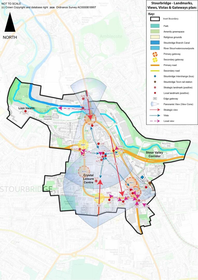
Table 3.1. List of Stourbridge Landmarks, Views, Vistas and Gateways
|
Strategic Landmark (Positive) |
Heritage asset/designations (where relevant) |
|
|---|---|---|
|
SLP1 |
Stourbridge Town Hall |
Grade II Listed, within Conservation Area and an Area of High Historic Townscape Value (AHHTV) and Archaeological Priority Area (APA). |
|
SLP2 |
St Thomas’s Church |
Grade I Listed, within Conservation Area and AHHTV. |
|
SLP3 |
Former Library and Art College |
Grade II Listed, within an AHHTV. |
|
SLP4 |
The Town Clock |
Grade II Listed, within a Conservation Area and an AHHTV and APA. |
|
SLP5 |
Bonded Warehouse |
Grade II Listed, within a Conservation Area. |
|
SLP6 |
Titan Works |
Heritage Asset in a Conservation Area. |
|
SLP7 |
Alexandra House, Enville Street |
Locally Listed, within an AHHTV. |
|
Local Landmarks (Positive) |
||
|
LLP1 |
The Old Bank (former Yorkshire Bank), no. 38 High Street |
In a Conservation Area, AHHTV and APA. |
|
LLP2 |
Nos. 101/102 High Street (Corner of Court Street) |
Locally Listed, within an Area of High Historic Landscape Value (AHHLV) and APA. |
|
LLP3 |
The Chequers Inn public house, no. 96 High Street |
Heritage asset within AHHLV and APA. |
|
LLP4 |
Methodist Church, New Road (ring road) |
Locally Listed within an AHHTV and Conservation Area. |
|
LLP5 |
The Church of Our Lady and All Saints, New Road (ring road) |
Grade II Listed, within an AHHTV. |
|
LLP6 |
Side Space, home of the Side by Side theatre company, in the former St. John’s United Reformed Church, St. John’s Road (ring road) |
Grade II Listed, within an AHHTV. |
|
LLP7 |
Strawberry Hill Gothic (7 Lower High Street) |
Grade II Listed, within the Conservation Area, AHHTV and APA. |
|
LLP8 |
King Edward IV College, middle of Lower High Street |
Heritage asset within the Conservation Area, AHHTV and APA. |
|
LLP9 |
Nickolls & Perks (wine merchants) Top of Lower High Street |
Grade II Listed, within the Conservation Area, AHHTV and APA. |
|
LLP10 |
The Duke William public house, 25 Coventry Street/corner of Duke Street |
Heritage asset within the Conservation Area, AHHTV and APA. |
|
LLP11 |
Lion Health (former Foster & Rastrick Works) |
Grade II* Listed within a Conservation Area. |
|
Edge Gateway |
||
|
EG1 |
Pedestrian gateway, subway connection from Stourbridge Interchange/Stourbridge Town rail station, arriving in Foster Street Place |
Gateway into the AHHTV. |
|
EG2 |
Pedestrian gateway from Hagley Road/Church Street into the High Street & vehicular gateway from St. John’s Road (ring road) into the top end of the High Street |
Gateway into the AHHTV. |
|
EG3 |
Pedestrian gateway (subway link) from Worcester Street into Market Street |
Gateway to the High Street Stourbridge Conservation Area and in the AHHTV. |
|
EG4 |
Pedestrian gateway (controlled crossing point over Bath Road (ring road) from the old town via Green Street/Lion Street into Bell Street |
Gateway to the High Street Stourbridge Conservation Area. |
|
EG5 |
Pedestrian gateway (subway link) from A458/Enville Street or from Hemplands Road into Crown Lane & vehicular gateway from A458/Enville Street onto Bath Road (ring road) |
Gateway to the High Street Stourbridge Conservation Area and AHHTV. |
|
EG6 |
Pedestrian gateway via underpass from Bradley Road/Lower High Street/A491 & St. John’s Road (ring road) into Lower High Street & vehicular gateway from A491 onto the ring road/St. John’s Road |
Gateway into the High Street Stourbridge Conservation Area and AHHTV. |
|
EG7 |
Pedestrian gateway (subway link) from A458 Birmingham Street to Duke Street & vehicular gateway from St. John’s Road (ring road) into Duke Street |
Gateway into the High Street Stourbridge Conservation Area and AHHTV. |
|
Panoramic View (View Cone) in/out of Stourbridge |
||
|
PV1 |
From A491 looking southwards across the bottom of Lower High Street into the heart of the town centre (with the tower of Stourbridge Town Hall and the spire of Our Lady & All Saints both visible) |
Grade II Listed: Stourbridge Town Hall (SLP 1) and spire of Our Lady & All Saints (LLP 5). Covers the AHHTV, the Conservation Area and APA. |
|
PV2 |
From the junction of Parkfield Road/Vauxhall Road looking northeast towards the town centre (clearly visible: the tower of the fire station, Side by Side Space - in the former St. John’s Church, former Library & Art College, and the spire of Our Lady & All Saints) |
Grade II Listed: former St John’s Church (LLP 6) former Library & Art College (SLP 3) and spire of Our Lady & All Saints (LLP 5). Covers the AHHTV and Conservation Area. |
|
PV3 |
From Bath Road (ring road) looking north towards the tree-lined horizon |
Looking out towards the Canal Conservation Area and SLP6. River Stour AHHLV towards trees with the churchyard of the Locally Listed Holy Trinity Church. |
|
Strategic Views |
||
|
SV1 |
From Worcester Street looking north across New Road (ring road) into Market Street and the heart of the town centre (with the tower of Stourbridge Town Hall visible) |
View into the Conservation Area, towards SLP 2 and SLP 1. |
|
SV2 |
From A491 looking southwards across the bottom of Lower High Street into the heart of the town centre (with the tower of Stourbridge Town Hall and the spire of Our Lady & All Saints both visible) |
View into the town centre Conservation Area, towards SLP 1 and LLP 5. |
|
SV3 |
From St. John’s Road (ring road) looking southwards across the core of the town centre to the spire of Our Lady & All Saints, New Road (ring road) |
View into the town centre Conservation Area, towards LLP 5. |
|
Vistas |
||
|
V1 |
From the bottom of Lower High Street looking southwards towards the top of Lower High Street (with the top of the tower of Stourbridge Town Hall visible) |
Within the Conservation Area, AHHTV and APA, looking towards SLP 1. |
|
V2 |
From Crown Square looking southwest along Market Street (with the tower/side of Stourbridge Town Hall clearly visible) |
Within the Conservation Area, AHHTV and APA, looking towards SLP 2 and back towards SLP 1. |
|
V3 |
From Crown Square looking southeast along the High Street (with the former post office visible) |
Within the Conservation Area, AHHTV and APA, looking towards SLP 4. |
|
V4 |
From Crown Square looking eastwards along Coventry Street |
Within the Conservation Area, AHHTV and APA, looking towards SLP 4. |
|
V5 |
From Crown Lane looking eastwards towards Nickolls & Perks on the corner of Coventry Street (The Old Bank to the right & The Mitre to the left) |
Within the Conservation Area, AHHTV and APA, looking towards LLP 9. |
|
Local Views |
||
|
LV1 |
From the High Street looking across the Ring Road (southeast) towards the former Library & Art College |
Looking towards SLP 3, within the AHHTV and APA. |
|
LV2 |
From the Ring Road looking southeast towards the former Library & Art College |
Same as above. |
|
LV3 |
From Hagley Road looking northeast towards the former Library & Art College |
The former Library & Art College is Grade II Listed (SLP 3) and in an AHHTV. |
|
LV4 |
From Church Street looking northwest towards the rear of former Library & Art College |
Same as above. |
|
LV5 |
Coventry Street looking northwest towards The Mitre public house |
In a Conservation Area looking towards Grade II Listed Mitre PH. |
|
LV6 |
Crown Lane looking northwest across the Ring Road towards Alexandra House, Enville Street |
Alexandra House is Locally Listed (SLP7) and in an AHHTV. |
|
LV7 |
Bath Road (Ring Road) looking northwest towards Alexandra House, Enville Street |
Same as above. |
|
LV8 |
Court Street looking southeast across New Road (ring road) towards the former Library & Art College |
The former Library & Art College is Grade II Listed (SLP 3) and in an AHHTV. |
|
LV9 |
Court Street looking southwest across New Road (ring road) towards Our Lady & All Saints |
Our Lady & All Saints is Grade II Listed (LLP 5). Within the AHHTV. |
|
LV10 |
Victoria Street looking southeast across New Road (ring road) towards Our Lady & All Saints |
Same as above. |
|
LV11 |
Victoria Street looking south across New Road (ring road) towards the Methodist Church, New Road |
Methodist Church is Locally Listed (LLP 4) and within the AHHTV. |
|
LV12 |
From A458/junction with St. John’s Road (ring road) looking west across the ring road towards the Duke William public house, corner of Duke Street/Coventry Street |
Within the Conservation Area, AHHTV, APA and looking towards LLP 10. |
|
LV13 |
From the junction of A491 High Street/Canal Street looking west along Canal Street (Bonded Warehouse) |
Within Canal Conservation Area and APA. |
Public Realm
3.25The town’s character is greatly influenced by its public realm, with some locations in need of upgrading. Public open spaces provide a focus for community activity and form connections within the town centre.
Policy DLPS4 Public Realm in Stourbridge
- The quality of streets and open spaces will be improved through development of proposals or local initiatives having regard to the following measures:
- Enhancement of the townscape to provide a high-quality space, particularly for the use of pedestrians and cyclists.
- The provision of locally distinctive hard and soft landscaping, seating and lighting, and public art to help create a clear identity for Stourbridge Town Centre.
- Public realm improvements should give more priority to pedestrian movement whilst retaining on-street parking in bays within an enhancement streetscape.
- The provision of bespoke designed surfacing and footway widening along the length of the zone to run into the Public Squares.
- The provision of greener throughfares including the planting of native or locally distinct trees. f. The accommodation of, and works to facilitate, the holding of markets and events within the Town Centre Core.
3.26It would be beneficial to soften the appearance of Stourbridge Ring Road through the introduction of greenery into this relatively robust urban environment, through the use of tree planting and planters around the inner and outer core of the Ring Road and resolve the competing needs of vehicles and pedestrians moving through the Town Centre core. This conflict is exacerbated by the narrowness of many footways and on-street parking, together with the volume and movement of traffic. Improvements to these streets are required to retain space for some on-street parking and the passage of vehicles, including emergency vehicles, whilst giving a greater priority to pedestrians within a greener space.
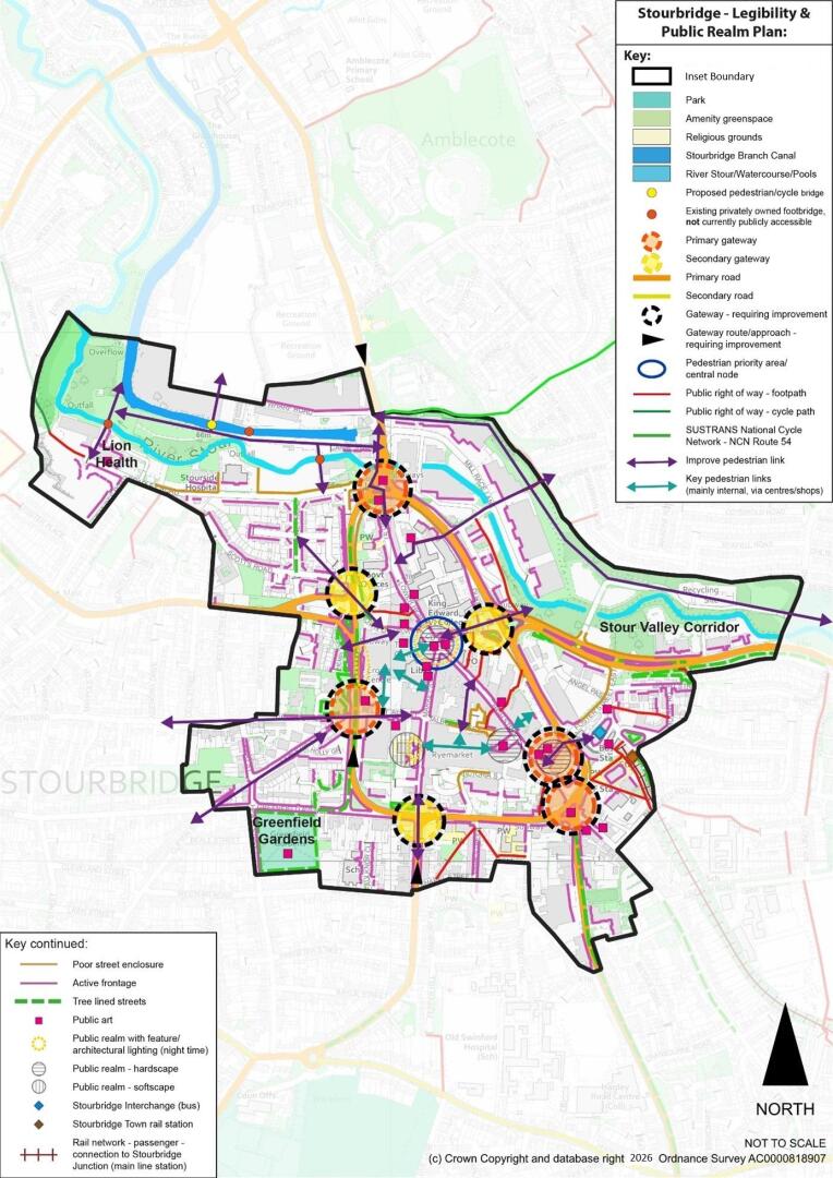
3.27There are specific areas within the townscape which require a visual uplift. These are often streets which predominantly function as service areas, or where there is little activity or interest for those passing through to appreciate, as well as there are some parts of the town centre which have poor, inactive frontages facing the public realm, in particular those fronting the Ring Road . In addition, several the town’s existing squares would benefit from an upgrade, enabling them to realise their function as places of congregation and as special spaces within the pattern of buildings. Also, enhancement of the existing gateways in order to create welcoming entrances into the town centre and helping improve legibility and wayfinding.
Figure 3.2: Stourbridge Legibility and Public Realm Plan
Historic Environment
3.28The historic environment and heritage assets will be conserved and enhanced as per Local Plan Policy DLP54 – DLP58. This section sets out the key characteristics of the Stourbridge inset plan area and the town-specific evidence base information for context, but no additional policy provisions to Policies DLP55-DLP58 are set out (other than in site specific allocations).
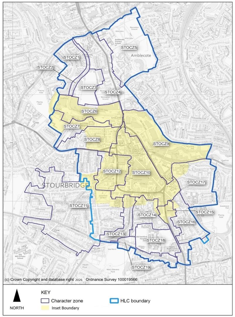
3.29The Stourbridge UHLC provides the evidence base to inform an understanding of the town's historic character. This evidence should be used in considering how new development proposals and the enhancement of existing townscapes and landscapes should respect the towns character and enhance local distinctiveness and full references should be made in Design and Access Statements accompanying planning applications to the Stourbridge UHLC. Design and Access Statements should clearly set out the steps that have been taken to achieve locally responsive outcomes through either traditional or more contemporary design solutions.
3.30The study describes the historical development of Stourbridge and identifies 19 Historic Townscape Character Zones within the Town Centre and beyond. For each Character Zone, individual buildings and spaces have been identified, which contribute positively or otherwise to local character (designated and non-designated heritage assets). Where physical evidence of historic character persists in the form of heritage assets that make a positive contribution to local distinctiveness, such assets should be conserved and wherever possible enhanced (in line with national and local planning policy). In addition to the High Street Stourbridge Conservation Area and the Stourbridge Branch Canal (Canal Street) Conservation Area (designated heritage assets), locally significant non-designated heritage assets have been identified including Areas of High Historic Townscape and Landscape Value and Archaeological Priority Areas (APAs).
Figure 3.3: Stourbridge UHLC Boundary and Character Zones
3.31One of the greatest design challenges that faces Stourbridge is to improve and raise the profile of the routes into and out of the Town Centre from the surrounding areas across the ring road.
Policy DLPS5 Stourbridge Ring Road
- Measures shall be encouraged which seek to reduce the visual impact of the ring road, including its dominance as a robustly urban and vehicle dominated space, and its sense of enclosure. Such measures should reduce the ring road’s severing effect, which currently disassociates the Town Centre from its surrounding areas.
- Gateways shall be formed at the interface between the Town Centre and the ring road. These spaces shall be enhanced to function as entrance points to the town, with each named to provide a distinctive sense of place. Public art and hard and soft landscaping should be incorporated to emphasise their visual distinctiveness including the planting of new trees. New development which encroaches into these spaces or otherwise compromises their function will be resisted.
- Any development within the ring road corridor shall provide an active frontage onto it and therefore a ‘welcoming face’ to the town. Development comprising the conversion of existing buildings within the ring road corridor will be expected to remedy any dead frontages onto it.
- No new advertisement hoardings shall be granted express consent within 30 metres of the edge of the ring road corridor.
- The existing subways under the ring road will continue to be enhanced, in particular to provide a light, secure and safe environment.
Justification
3.32The ring road functions effectively in channelling traffic, but it is the dominant infrastructure within the town and, as a result, constrains pedestrian movement, funnelling people into subways under the multi-lane highway.
3.33The ring road also has had the effect of severing existing development blocks, leading to the exposure of the backs and sides of buildings and service areas, some of which are enclosed by advertisement hoardings (which serve to further reinforce the visual dominance of the ring road corridor). This gives rise to a fragmented environment. Potential improvements to the public realm of these areas could be achieved through the introduction of public art, such as green walls and murals.
3.34It is vital that new development has an active frontage onto the ring road and improves permeability, giving preference to pedestrian and cycleway connections across the ring road, greening the fringes and redressing the entrances at the outward face of the Town Centre.
Pedestrian Access and Cycling
3.35All developments should retain and improve existing cycle and pedestrian routes and provide new connections to facilitate access and allow for safe and easier movements around sites and the Town Centre.
Policy DLPS6 Pedestrian Access and Cycling in Stourbridge
- All appropriate existing pedestrian routes, especially the network of Public Rights of Way and existing subways under the ring road shall be retained and, where opportunities arise, improved.
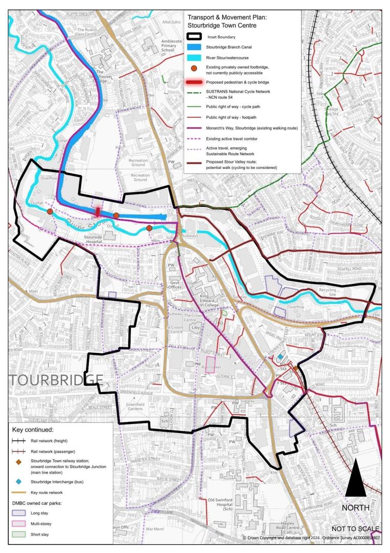
- New pedestrian links shall be created, particularly to link the Opportunity Sites and housing allocations with the Town Centre, the public transport hub and the Stourbridge Branch Canal and River Stour infrastructure. Wherever feasible these links shall incorporate cycleways, demarcated as distinct from the pedestrian paths. This includes:
- Proposed new bridges over the canal and River Stour connecting any new housing sites (including Bradley Road) providing pedestrian and cycle linkages.
- New surface level crossings across the Stourbridge ring road, suitable for cyclists and pedestrians, shall be provided at:
- The eastern quadrant of the ring road at the junction with Birmingham Street
- The north-west quadrant of the ring road (Opportunity Site 1)
- Secure cycle parking shall be provided along the national cycle route (Sustrans Route 54) and within Stourbridge Town Centre, particularly in Lower High Street.
- Other cycle routes shall be signposted, delineated, and marked out (where feasible), and the environment which these routes pass through will be enhanced:
- Along the River Stour and Stourbridge Branch Canal, and routes which link into the green infrastructure network,
- Routes which link to Sustrans Route 54,
- Routes which access Mary Stevens Park and Wollaston Recreation Ground.
Justification
3.36Pedestrian access across the ring road is currently via six subways and two surface level crossings. The subways provide safe and easy access between the Town Centre and surrounding areas, particularly for wheelchair users. However, these subways, which include the main passage from the Town Centre to the public transport hub, are not popular and often present poor-quality environments.
3.37The subways are likely to have to remain as some are the primary or only means of accessing the town from the adjoining areas. However, most will require upgrades to make them safer and more inviting for users. Additional surface level crossings will also be considered to enhance greater permeability within the environment in general, lessen the visual and physical impact of vehicular traffic and provide direct links to the Town Centre.
3.38A national cycle route (Sustrans Route 54 from Stourport to Derby) passes through the plan area, this Inset Plan aims to facilitate and sign these routes and enhance the environment of the corridors through which they run. This includes providing additional cycle stands, this will allow those using the national cycle route and residents cycling into the town to use the facilities offered by Stourbridge, as well as the provision of new tree planting.
3.39It is important to continue to enhance the active travel offering in Stourbridge, this includes the development of new cycle and walking routes and the development of a Dudley Local Cycling and Walking Infrastructure Plan.
3.40Enhancing the current pedestrian and cycle linkages around the Canal and River Stour in the Stourbridge Wharf area is important to promote active travel and create linkages within the communities. It is therefore important that new developments within these areas, such as Bradley Road East and West incorporate the development of new bridges to provide access to the surrounding areas and provide connections for residents on both sides of the canal and rivers to access surrounding infrastructure including, the Public Open Space, Riverside House, War Memorial Athletic Ground and Lion Health. While also providing better connection to the wider pedestrian and cycle network.
Figure 3.4: Transport and Movement Plan: Stourbridge Town Centre
Stourbridge Town Inset Plan Area Site Allocations
3.41Stourbridge Town Inset Plan Area contains three ‘Opportunity Sites’ which have been identified where redevelopment and regeneration would provide benefits to Stourbridge Town Centre. These represent mixed use sites, which may include residential development. The Opportunity Sites do not preclude or diminish the importance of investment or change elsewhere in the centre. They simply reflect the Council’s wish to prioritise use of its resources to kick start and progress projects which will have a significant impact and act as a catalyst for wider change.
3.42In addition to the opportunity sites, there are several sites which have been identified within Policy DLP10 as part of the overall housing land supply as summarised below.
Table 3.2: Summary of Stourbridge Allocations
|
Site |
Mixed Use | Minimum Residential Capacity |
|---|---|---|
|
Opportunity Sites |
||
|
North of Birmingham Street (DLPSOS1) |
Yes |
70 |
|
Mill Race Lane (DLPSOS2) |
Yes |
None |
|
Rye Market (DLPSOS3) |
Yes |
50 |
|
Housing Allocations |
||
|
Bradley Road (East) (DLPSH1) |
No |
46 |
|
Bradley Road (West) (DLPSH2) |
No |
24 |
|
64-67 High Street, Stourbridge (DLPSH3) |
No |
40 |
|
Peugeot Garage, Hagley Road (DLPSH4) |
No |
35 |
|
Titan Works, Old Wharf Road (DLPSH5) |
No |
26 |
|
36-42 Market Street (DLPSH6) |
No |
31 |
3.43A policy is provided for each Opportunity Site which identifies the acceptable uses.
Stourbridge Town Centre Opportunity Site: North of Birmingham Street
3.44This Opportunity Site is located to the north of Birmingham Street and south of the Penfields Estate. The area is currently comprised of a number of occupied commercial properties, surface level car parking and green space.
3.45The site is outside of the Town Centre Core Area and is accessed off Birmingham Street, a busy A road which connects Lye and Stourbridge Ring Road. The River Stour runs through the site and offers an opportunity to create better connectivity to the river and create an active frontage to both Birmingham Street and the river. The site could deliver a mix of complementary uses including new residential developments and expansion of the commercial services while conserving and enhancing where possible the existing nature conservation at the site.
3.46While the site is located outside of the Stourbridge Town Centre Conservation Area, consideration needs to be given to the impact of proposals on the site’s designation as an Area of High Historic Landscape Value (AHHLV). In addition, given the part of the site’s designation as a SLINC and the River Stour location within the site, proposals will need to ensure they conserve and enhance the nature conservation importance and ecological surveys will need to be submitted with any planning applications. Parts of the site are located within Flood Zone 3 (see Level 2 Strategic Flood Risk Assessment (2025)). The built development should be steered to the areas within the site of lowest risk from fluvial and other sources of flooding risk. The Exceptions Test will need to be applied if any ‘more vulnerable’ residential development is sited in Flood Zone 3 at the planning application stage.
Policy DLPSOS1 Stourbridge Town Centre Opportunity Site: North of Birmingham Street
Acceptable Land Uses
- Mixed use development including:
- Class E – Commercial, Business and service uses, which would complement the existing commercial offerings on the site, excluding uses falling within Class E (g) (ii) and (iii) uses.
- Residential developments (Class C3) with an indicative capacity of 70 dwellings, but this capacity may vary as part of any mixed use developments on the site.
- Any developments should protect and enhance the nature conservation in the area, in particular the designated SLINC.
- There are opportunities to provide increased connectivity across Birmingham Street, linking to the town centre.
Stourbridge Town Centre Opportunity Site: Mill Race Lane
3.47Mill Race Lane Opportunity Site is located to the north east of Stourbridge Ring Road. The site can be accessed from Stourbridge Ring Road and the A491 (High Street). There is pedestrian access to the town centre using an underpass running under the ring road. There is potential to further enhance the active travel around Stourbridge through pedestrian links through the site, connecting the residential development to the north of the site to Stourbridge Town Centre.
3.48The site currently contains a number of large industrial units which are occupied by a range of uses. This includes a number of employment uses as well as some retail units which complement the surrounding industrial uses (e.g. Screwfix). The site also contains a number of leisure uses particularly in the southeast of the site. This includes food establishments, a nightclub, and children’s indoor play centre. Given the range of uses the site is currently active during the day to the employment and food venues, while also playing a role in the night-time economy of Stourbridge due to the active nightclub on the site. There is potential to expand the leisure offerings on the site, particularly around the current leisure uses subject to proposals meeting the requirements of policies DLP21 and DLP 22.
3.49While the site is outside of the Stourbridge Town Centre Conservation Area, consideration needs to be given to the impact of proposals on the site’s designation as an Area of High Historic Landscape Value (AHHLV) and as an Archaeological Priority Area (APA). In addition, part of the site is a designated SLINC and the River Stour location within the site, relevant proposals will need to ensure they conserve and enhance the nature conservation importance and ecological surveys may be required.
Policy DLPSOS2 Stourbridge Town Centre Opportunity Site: Mill Race Lane
Acceptable Land Uses
- Mixed use development including:
- Retention of the existing and new employment uses (B2 and B8)
- Leisure uses (Class E and Sui Generis) which complement the existing offering of leisure uses on the site or the existing employment uses. New retail provision on the site would not be supported, as they should be located within the Stourbridge Town Centre Core Area
- New leisure uses should demonstrate their compliance with Polices DLP 21 and DLP 22 particularly ensuring any proposed use would not conflict with any of the operational employment uses on the site.
Stourbridge Town Centre Opportunity Site: Ryemarket
3.50The Opportunity Site is located within Stourbridge Upper High Street between the High Street and Market Street. The Ryemarket is a purpose-built shopping centre dating from the 1970’s. The site fronts an area of public realm towards the High Street, with entrances also from Market Street and Talbot Street.
3.51The Ryemarket comprises of a purpose-built covered shopping centre with retail at the ground floor, and a multi-storey car park above. An area of public realm sits between the Ryemarket and the High Street, which leads to the main frontage of the Shopping Centre with a number of retail units and cafes fronting the public realm area. There are opportunities to enhance the public realm surrounding the Ryemarket.
3.52Part of the site fronting Market Street falls within Stourbridge High Street Conservation Area and there a number of listed buildings adjacent to the site, this includes the Grade 1 Listed St Thomas’ Church sited opposite. Any proposals on the site should ensure they preserve and enhance the character and/or appearance of the Conservation Area and any upper floor developments should ensure that they do not impact on the setting, significance and views of St Thomas’ Church and neighbouring heritage assets.
Policy DLPSOS3 Stourbridge Town Centre Opportunity Site: Rye Market
Acceptable Land Uses
- Mixed use development including:
- Class E uses at Ground Floor within the Town Centre Core Area in accordance with Policy DLP 24.
- Residential Development at upper floors including replacement of the existing car park. Indicative capacity of 50 dwellings, however this is dependent on the scale of any proposed development. A high-rise development above the Ryemarket Car Park’s current height would not be supported.
- Retention/ refurbishment of some public parking should be incorporated in any new proposals for the conversion of the upper floor/ car park to residential.
Evidence
- Responses to the BCP Draft Plan consultation (2021)
- Black Country Centre Study (2020) and Update (2021)
- Black Country Historic Landscape Characterisation (2010)
- Black Country Historic Landscape Characterisation Study (2019)
- Borough-Wide Urban Historic Landscape Characterisation Study (2016/2023)
- Historic Environment Supplementary Planning Document (2017)
- Stourbridge Area Action Plan Spatial Development Framework Urban Design Evidence Base (2011)
- Stourbridge Branch Canal (Canal Street) Conservation Area Appraisal (2007)
- Historic Landscape Characterisation for Stourbridge
- Historic Environment Record (HER)
- National Design Guide
- Historic England Good Practice Advice Notes (GPAs) and Historic England Advice Notes (HEANs)
- Residential Design Guidance SPD (2023)
Delivery
- Historic Landscape Characterisation documents
- Adopted Conservation Area Character Appraisals
- Development Management process including Design and Access Statements and Statements of Heritage Significance
- Supplementary Planning Documents
- A regularly updated and maintained Historic Environment Record (HER).
Figure 3.5: Stourbridge Inset Plan