
Dudley Local Plan Part Two
2. Dudley
Introduction
2.1This chapter sets out how Dudley Town Centre will develop and change over the plan period. A vision for the town centre is set out, which will be delivered through the Local Plan policies and site allocations (up to 2041). This chapter elaborates on the policies set out in Part One of the Dudley Local Plan by providing specific policies relevant to Dudley Town Centre. This chapter should be read primarily in conjunction with Chapter 10 (Centres and Town Centre Uses) within Part One, along with other relevant Part One policies as applicable to individual proposals.
2.2Dudley Town Centre lies within Regeneration Corridor 2 which covers Dudley, Brierley Hill and Stourbridge, following the proposed new Metro line route. This new rapid transit network will provide first class access to the rest of the Black Country and to Birmingham. The Local Plan expects that development in this corridor will include high quality housing development in the centres and along the corridor. It is also intended that the corridor will have an excellent green infrastructure network through enhanced green spaces and parks as well as increased biodiversity and improved links into such areas as Wrens Nest National Nature Reserve. The town will be a key place to work and invest in. Its regeneration will reinforce and reinvent a sense of place and local identity. Dudley town will have a tourism focus of regional and national repute.
2.3In October 2023 Dudley was named as one of 55 local authorities to receive £20million of government funding over ten years under the Long-Term Plan for Towns Initiative. Initial planning is underway for how the funding will be invested. The Long-Term Plan for Towns will require the Dudley Town Board to develop its own plan for the town, aligned to three key themes for investment- safety and security; high streets, heritage and regeneration; transport and connectivity.
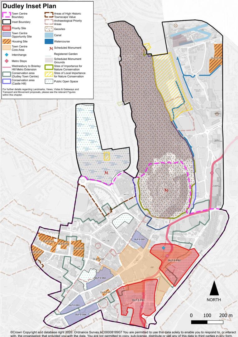
The Dudley Inset Plan Boundary
2.4This inset chapter covers Dudley’s Town Centre and its Conservation Area and encompasses the Castle Hill area and its Conservation Area, which includes Dudley Castle and Zoo; The Black Country Living Museum; the Dudley Canal Trust and Priory Hall and Park to the west of the Castle. The Dudley Town Centre and Town Centre Core Area boundaries are identified on the Dudley Inset Policies Map. The Dudley Inset Boundary is a wider area than the designated town centre boundary and has been identified to capture the special landscape and historic character of the area as well as opportunities for future growth and regeneration. The Castle Hill area has a globally unique cluster of heritage attributes that ensure this area’s future profile and success in the visitor economy. It is therefore of great importance to ensure they are connected physically to the town centre.
2.5Castlegate Park (out of town retail and business park) lies just outside the Inset Plan boundary (to the east of the Castle Hill area) and offers a range of leisure, office and hotel facilities. Whilst it lies outside the Inset Plan boundary the improvement of links and connectivity between Castlegate and the town centre is encouraged, particularly with the forthcoming Metro stops that will be located in this area alongside the A4037.
2.6Large parts of the inset plan area fall within the Dudley Town Centre and the Castle Hill Conservation Areas. There are three Scheduled Monuments (SMs) and the Priory Park Registered Park and Garden. The town has benefited from recent investment in the restoration of historic buildings and the public realm (via the National Lottery Heritage Fund).
2.7The town of Dudley is a very special and unique place in terms of geology. Just outside the Inset Plan area is the UK’s first National Nature Reserve for geology (Wrens Nest NNR). Most of the towns’ historic buildings take their appearance from the hard pale limestone of Dudley and its cobbled stones in older byways come from nearby hills. This geology has given the town a very distinctive character of hills and valleys. The topography has clearly influenced the physical layout and historical development of the town centre. This is described in detail in the Dudley Urban Historic Landscape Characterisation study (UHLC) and in the Conservation Area Character Appraisals for Dudley Town Centre and Castle Hill.
2.8Closely located to Dudley Town Centre is Castle Hill Woodland, which is a Site of Importance for Nature Conservation (SINC) for both its geological and nature conservation value. This site and the immediately adjacent Peggy’s Meadow Site of Local Importance for Nature Conservation (SLINC) provide an important natural green space and wildlife corridor linking into nearby Wrens Nest NNR.
2.9The town is home to a ‘learning quarter’ focused on the modern Dudley College facilities within the centre. The Very Light Rail Innovation Centre adjacent to the Castle Hill area provides a unique research facility alongside the new Black Country and Marches Institute (to address regional Science, Technology, Engineering and Maths (STEM) skills shortages). With a new Higher Education complex at the former Hippodrome site, the Castle Hill area will also be a key learning hub for the town.
2.10Dudley Castle, together with Dudley Zoo, the Black Country Living Museum and the Canal Trust, Town Hall and their connections to adjacent attractions and amenities including Wrens Nest NNR, define Dudley as a key tourism/visitor centre. These attractions, in connection with the other 40 or so geologically significant sites across the Black Country form the core of the Black Country Global Geopark. This designation aims to raise the profile of the area’s visitor economy to help to support and underpin those very aspects that make Dudley and other areas of the Black Country unique.
2.11The Castle Hill redevelopment scheme (being undertaken in Phases) has already delivered new visitor infrastructure to Dudley Zoo, The Black Country Living Museum, Dudley Archives and Dudley Canal Trust and the intention is for this to continue with future phases (see further information below under ‘Dudley Town Centre and Surrounding Areas - Preferred Uses’).
2.12There are three public parks within the Dudley inset plan area which offer different landscape characteristics: these are Priory Park, Coronation Gardens and Inhedge Gardens. Priory Park contains the medieval Priory of St James (a Scheduled Monument and Grade I Listed Building) and Priory Hall (Grade II Listed Building). The park was added to the National Register of Parks and Gardens in 2002 and restoration work via Heritage Lottery Funding has been undertaken in recent years. Coronation Gardens provide an attractive formal green space reflecting the civic focus (outside the Council House) and contain the Apollo fountain and Dudley War Memorial. Inhedge Gardens (also known as Horseley Gardens) formed part of large houses with ancillary buildings, which were joined up as part of Horseley House by 1904. This links into the Opportunity Site at the Trident Centre and improvements here would greatly enhance this part of the town.
2.13Formal sports and leisure provision is available at Priory Park (pitches), the newly completed Duncan Edwards Leisure Centre, and the indoor sports hall on Tower Street constructed as part of Dudley College Evolve Building.
2.14Dudley town centre has no direct access to the rail network, however, the forthcoming new Metro line will significantly enhance the connectivity of the town centre to the wider Black Country and Birmingham area as well as within the town centre area itself i.e., stops throughout the town and associated pedestrian/public realm connection improvements. Alongside this, the redeveloped bus station will provide a modern transport interchange, enhancing capacity and the experience of sustainable transport into the town centre.
2.15Retailing remains an important function of the town, including the outdoor market. Reflecting national trends for town centre retail, its role has however declined in recent years. It will be important for a wider range of town centre uses and residential developments to come forward to contribute to the town’s vitality and viability.
Vision and Objectives
‘Dudley is a historic market town looking to the future. By 2041 it will be a town which serves the needs of its local population, and which remains the strong focus for civic life, for town centre living, for shopping, tourism and heritage, leisure and education.
This will be achieved by reshaping and reasserting its role within the Borough, drawing on its considerable assets, encouraging investment in opportunities and ensuring that Dudley becomes a place with a richer mix of town centre uses and an increased resident population. The environmental and historic quality, green infrastructure, transport connectivity, accessibility and safety and security of the town centre activities and assets will be enhanced.
2.16The following specific objectives for Dudley Town Centre are identified:
- To support and encourage investment within the town centre by building on the success of recent development projects; the refurbishment and renewal of town centre buildings and the public realm; and maximising the benefits of the forthcoming Metro links and new transport interchange.
- To continue to develop Dudley as a tourism and leisure destination, utilising its historic assets and integrating the Castle Hill area into the town centre.
- To continue to develop Dudley’s educational offer, providing access to higher education opportunities whilst helping to stimulate activity within the town centre and raising its profile.
- To encourage and facilitate further residential development within the town centre to help stimulate activity both during the day and in the evening and support the growth of a vibrant community.
- To ensure that the special character and quality of Dudley’s historic environment is fully appreciated and that this is exploited to its best advantage.
- To protect and improve access to Dudley’s unique landscape and natural assets including the Castle grounds and surrounding areas and beyond to the Wrens Nest National Nature Reserve.
- To provide, protect and enhance a well-connected landscape and public realm setting of streets, routes and public spaces that is attractive, safe, lively, and pleasant to use.
- To ensure the delivery of high quality and innovative design that respects and enhances the unique features of Dudley town centre.
Supporting Information and Policies
Dudley Town Centre and Surrounding Areas – Preferred Uses
Town Centre and Town Centre Core Area
2.17In line with national and local planning policy, any developments for new main town centre uses will be directed towards the Town Centre and Town Centre Core Areas, as appropriate. The diversification and repurposing of Dudley Town Centre will be supported by approving development that enhances the vitality and viability of the centre. This is subject to the proposed use being appropriate to its location within the town centre and in accordance with Policy DLP24, which sets out the strategic approach to town centre development within the borough, including appropriate uses. This section provides specific information relevant to Dudley Town Centre for context, but no additional policy provisions to Policy DLP24 are set out other than in site specific allocations.
2.18The town centre (as defined by the town centre boundary) will remain an important focus for day-to-day shopping and a range of other town centre uses such as offices, leisure and cultural facilities. As recognised in the Local Plan, in view of the changing nature of town centres, there is a need for them to diversify in terms of uses that promote their vitality and viability; residential developments will have an increasingly important role alongside leisure and entertainment uses.
2.19The supporting evidence to the Local Plan identifies there is no quantitative need for additional retail, leisure and office floorspace. It does identify a qualitative need for an anchor food store within Dudley Town Centre, but there are no timescales for this other than up to the end of the plan period (and there have not been any specific proposals put forward as part of the Local Plan process). The emphasis therefore is on the consolidation of core areas and the diversification of uses on development sites to enable the repurposing of town centres, taking account of the most up to date information available on needs at the time of any specific proposals.
2.20Alongside this, the recent changes to the Use Class Order (wherein retail uses now lie within the same ‘E’ Use Class as other uses, including food and drink or offices) mean that retail uses are now able to change more freely to other uses (i.e., without the need for planning permission). Whilst this enables town centres to become more flexible and responsive to changes, it does mean that it is now more difficult to manage the loss of retail and some other more traditional town centre uses.
2.21Nevertheless, in line with national planning policy it remains important to identify the Town Centre Core Area for the key purpose of identifying whether a retail development proposal represents edge of or out of centre. It is recognised that there is likely to be a diversification of uses within the Town Centre Core Area, however, any new proposals for retail development will still be directed towards it in the first instance.
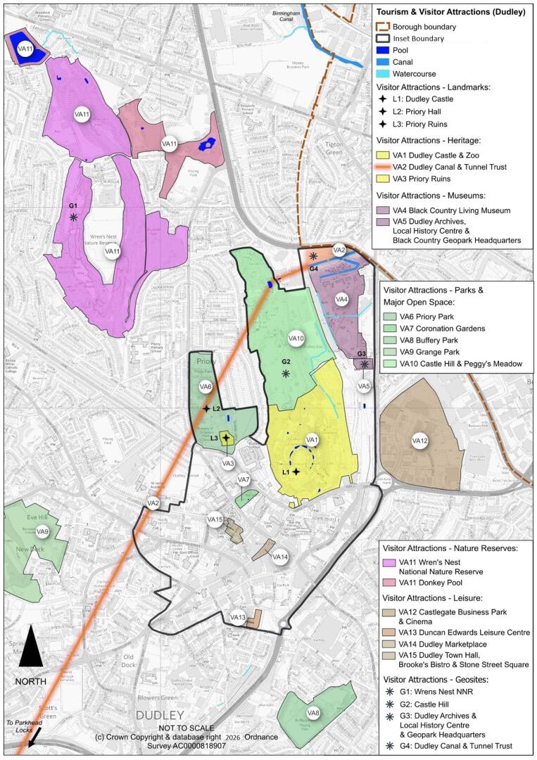
2.22Dudley town centre has a particular function as a heritage and leisure focus for regeneration and this can be enhanced further via new developments and initiatives (see Figure 2.1 below). These include the implementation of the ‘Castle Hill Vision’ (2019) (Phases 1 and 2 already underway or completed) or the reintroduction of leisure and tourism uses by the appropriate repurposing of vacant premises, such as the Museum and Art Gallery at Priory Street/Stone Street. Associated uses, including food and drink provision and visitor accommodation will also complement this focus, with the potential to create clear ‘quarters’ for leisure and entertainment in the town e.g., Stone Square which contains existing food and drink provision and has been earmarked for additional visitor accommodation. The development of additional education facilities to further enhance the town’s existing provision and learning quarters is also a key objective for Dudley.
2.23Vacant office buildings offer an opportunity to be repurposed considering changes to the town centre office market. Some former large-scale offices in the town centre have already been converted for residential use (Falcon House) or have been demolished (Cavendish House) for alternative uses.
2.24As set out in Policy DLP24 there is an evidenced qualitative need for an anchor food store within Dudley Town Centre. A specific site for such a development is not identified at this time. Dudley Council will keep this need under review and will work proactively with landowners and developers through reviewing, identifying and investing in suitable sites within the town centre that may serve to meet this need. This includes consideration of the potential for repurposing existing floorspace within the town centre and the use of land or existing units within the town centre Priority and Opportunity Sites (where appropriate).
2.25The proposals for the individual Priority and Opportunity Sites reflect the overarching Vision for the town centre, with preferred uses identified for each site (see Priority and Opportunity Site policies).
2.26In addition to the housing provision at the Priority and Opportunity Sites, several housing allocations are identified within the plan area. There is a concentration of these along Wolverhampton Street, which offers the opportunity for a ‘corridor’ of potential change towards residential development that could serve to help regenerate this part of the town centre.
Figure 2.1: Dudley Town Tourism and Visitor Attractions
Areas outside the Town Centre Boundary Castle Hill
Castle Hill
2.27The Castle Hill area is primarily that covered by the Castle Hill Conservation Area and its immediate surrounds. It represents a vital hub for the town’s leisure and tourism facilities, as well as education and training opportunities. Whilst the southern part of the area (including Dudley Castle and Zoo) lies within the town centre boundary, the northern part of the site (primarily occupied by the woodland area) lies outside the town centre boundary.Policy DLPD1 Areas outside the Town Centre Boundary – Castle Hill
- The Castle Hill Vision identifies the potential for the provision of enhanced leisure and tourism provision in the Castle Hill area, including improved links into the town centre and enhancements to the green infrastructure of the town. Development proposals which help to deliver the Vision will be supported in principle.
Justification
2.28A ‘Castle Hill Vision’ (2019) has been prepared to guide the future development of this area. The Vision identifies several projects related to improvements and investments to the Dudley Zoo and Castle and Castle Hill Woodland. It represents a collaboration between the zoo, the council and other stakeholders and is being implemented in phases.
2.29The first phase of the Castle Hill Vision included a new zoo entrance, a new access road off Tipton Road and the expansion of the existing zoo car park. Phase two includes proposals to transform the four Tecton Buildings and create a new mixed-use facility which could be used for activities, training and education, meetings and conferences. Part of the vision also includes a new university centre (Health Innovation Dudley) to expand the town’s learning quarter, which will be on the site of the former Hippodrome (at the foot of Castle Hill).
2.30The Dudley Town Centre Area Action Plan (2017) identified Opportunity Site (7-Castle Hill), which lies directly to the east of the Castle Hill Conservation Area. This has been the subject of recent developments including the Very Light Rail Innovation Centre and the Black Country and the Marches Institute of Technology. The forthcoming Metro line will cross the A4037, to the east of Castle Hill. To the northeast, the Castle Hill areas’ links to the Black Country Living Museum, Dudley Archives and Dudley Canal Trust are also important and have been the subject of improvements in recent years.
2.31The continued implementation of the Castle Hill Vision will serve to enhance the visitor experience to the town centre, including its surrounding attractions. The projects which are likely to be the focus of work going forward include improvements to the Castle Hill woodland and its connections to the town, surrounding attractions and Wrens Nest NNR. Key potential projects include:
- Ongoing enhancements to the existing major tourist attractions, including Dudley Castle and Zoo (and its unique Tecton Buildings) and Dudley Canal and Caverns.
- Enabling Castle Hill woodlands to become an improved visitor attraction, with improved access to paths, improved signage and interpretation of the area.
- Reconnection of Castle Hill with Dudley Town Centre via Castle Street.
- Enhanced access to the Sharrington Range and gatehouse within the Castle.
2.32The Castle Hill Area is important for its ecological, geological and heritage assets and development proposals should protect, conserve and enhance these features (in accordance with national and local planning policies). Proposals should have particular regard to Castle Hill Conservation Area Appraisal (see further details in the ‘Historic Environment’ section below).
Design and Public Realm Design
Design
2.33Policies DLP4 and DLP39 provide the overarching context for considering design quality. Regard should also be had to DLP policies for the historic environment. This section sets out those characteristics of the most importance to the Dudley inset plan area and town centre specific policies.
Policy DLPD2 Dudley Town Design - Landmarks, Views, Vistas and Gateways
- All new development should have regard to Policy DLP4, Policy DLP39 and Policy DLP54 to deliver high quality design and ensure the conservation and enhancement of heritage assets. Developments within and in the setting of the Conservation Areas should also have regard to Policy DLP55.
- The town centre key landmarks, gateways views and vistas are listed in Table 2.1 and are shown in Figure 2.2. New development and proposed alterations to existing buildings should:
- Enhance the sense of arrival by improving existing gateways and where appropriate create new ones.
- Create architectural corner features and new landmark features to improve the understanding of the town where appropriate.
- Conserve and enhance important existing landmarks, views, and vistas, commensurate with their status.
- Respect building lines, where appropriate, to reflect the local design context, including having regard to local views and vistas.
- Respect the height and mass and visibility of existing Dudley landmarks (see also Policy DLP54).
- Ensure that new buildings have a scale, mass, height and impact that is responsive to its context and sensitive to its roofscape/skyline.
- Create variations in roofscape that will respect important local and strategic views.
h. Ensure that larger development facades and rooflines reduce their scale and massing by subdividing into smaller architectural elements.
- Where new development is likely to have an impact on an identified view, vista, or landmark, accurate visual representations should be provided as part of any development proposals. Choice of materials and finishes should take into account the existing design context.
Justification
2.34Dudley Town Centre has a distinguished heritage as a planned medieval market town set out along a limestone ridge with distinctive landmarks that can be identified from distant views e.g., the spire of St Thomas’s (Top) Church at the western end of the town and the remains of Dudley Castle to the east. On each side of the linear connection of High Street, Market Place and Castle Street connecting these landmarks, lies the streets, lanes and alleyways whose course has altered little since their medieval layout. The medieval town layout is centred on the Market Place, with a strong connection to the Castle and the buildings contained along the street that connects Top (St Thomas’) and Bottom (St Edmund’s) Church, namely the Historic Central Spine.
2.35Whilst the remains of the medieval buildings have substantially changed, the patterns of connection, burgage plot and the topography of the town is clear in many places and provides a structure to both respect and inspire new development.
2.36Dudley town centre has a prominent skyline and roofscape, accentuated by the topography and defined by bold built form such as the spire of Top Church and the tower of Bottom Church, and the memorial tower on the town hall. The castle provides a unique backdrop and outlook from many viewpoints in and around the town centre. It was intended to always be conspicuous from the time of its construction in the 11th century with its tower positioned to dominate Dudley, enabling it to control the approaches to the town. Historic paintings and drawings of Dudley from the early 19th century onwards always depict the topographical dominance of Dudley Castle, Top Church and Bottom Church and it is this ‘historic view’ that has managed to be maintained to the present day. These features are not only significant historic landmarks but are also of huge communal value as they help people to navigate or identity with a particular location.
2.37Some aspects of the current built form (e.g., those areas backing onto some parts of the town) are however weak, especially where servicing areas face the street. There is also a lack of prominent built form to address the gateways of the town centre, arrival points and visitor attractions. Good urban design at these entry points is particularly important in providing first impressions of the town.
2.38Improving the sense of arrival and the way people move and find their way around the town centre is important as it reinforces a sense of place and creates better connections to other distinctive places and heritage assets. Significant to the Dudley Inset Plan area are its unique historic and environmental assets and its tourism role, therefore, it is essential that these components are connected to ensure residents and visitors can navigate their way from place to place effectively.
2.39Views and landmarks within Dudley help people find their way around and add variety and interest to the townscape that reinforces its sense of place and gives local identity. When buildings are designed poorly, or when they are out of scale or sited within particular sight lines, it can have a detrimental impact on the quality of the view and amenity it offers to local people and visitors. The Dudley Urban Historic Landscape Characterisation (UHLC) and the Conservation Area Character Appraisals for Dudley Town Centre and Castle Hill are of direct relevance when considering views, landmarks and vistas into, out of and within the boundary of the two Conservation Areas or that could affect their setting.
2.40Managing change in the town will be carried out at different scales from very small-scale opportunities to larger projects. In all cases attention to scale, mass, height, building form, building frontage, roofscape, impact on skyline, views and vistas will need to be taken into account and considered within the context of the whole landscape to ensure that development complements the many areas of good built structure and overall townscape character.
2.41The DLP references the intention to produce a borough-wide design code. This design code will need to reflect the special features of Dudley town centre, taking into account the existing Dudley town specific design related policies and their supporting evidence base.
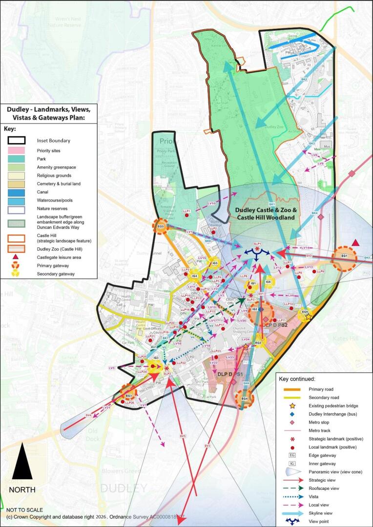
Table 2.1: List of Dudley Landmarks, Views, Vistas and Gateways
| Strategic Landmark (Positive) | Heritage asset/designations (where relevant) | |
|---|---|---|
|
SLP1 |
Dudley Castle and Zoo and Castle Hill Woodland |
Scheduled Monument, Grade I Listed, Geosite and in Castle Hill Conservation Area. |
|
SLP2 |
St Thomas & St Luke Church (Top Church) |
Grade II* Listed and in Dudley Town Centre Conservation Area, also an Archaeological Priority Area (APA). |
|
SLP3 |
St Edmund King & Martyr Church (Bottom Church) |
Grade II* Listed, in a Conservation Area and also in an APA. |
|
Local Landmarks (Positive) |
||
|
LLP1 |
Priory Ruins (within Priory Park) |
Scheduled Monument, Grade I Listed, in a Registered Park and Garden and in Area of High Historic Townscape Value (AHHTV). |
|
LLP2 |
Dudley College (original campus building) – The Broadway |
Locally Listed, in an AHHTV. |
|
LLP3 |
Kudos House – former Dispensary – Ednam Road |
Grade II Listed, in a Conservation Area. |
|
LLP4 |
Apollo Fountain – Coronation Gardens |
Heritage asset in a Conservation Area. |
|
LLP5 |
Dudley College – “Evolve” building/Former Dudley Fire Station – Tower Street |
Heritage asset in a Conservation Area. |
|
LLP6 |
Earl of Dudley Statue – Castle Street |
Grade II Listed, in a Conservation Area. |
|
LLP7 |
Dudley Zoo & Castle entrance – Tecton structure |
Grade II* Listed, in a Conservation Area. |
|
LLP8 |
Former Odeon Cinema – Castle Hill |
Grade II Listed, in a Conservation Area. |
|
LLP9 |
Station Hotel – Castle Hill / Trindle Road |
Heritage asset in a Conservation Area. |
|
LLP10 |
St Thomas of Canterbury RC Church – Trindle Road |
Grade II Listed, in a Conservation Area. |
|
LLP11 |
Metro Pub – Porters Field |
Heritage asset in a Conservation Area. |
|
LLP12 |
Dudley Council Offices – Priory Road |
Grade II Listed, in a Conservation Area. |
|
LLP13 |
Dudley Town Hall and 1st World War Commemorative Tower – St James’s Road |
Grade II* Listed, in a Conservation Area. |
|
LLP14 |
Dudley Public Library- St James’s Road |
Grade II Listed, in a Conservation Area. |
|
LLP15 |
Saracens Head – Public House & Stone Street Square |
Grade II Listed, in a Conservation Area. |
|
LLP16 |
Former Dudley Museum & Art Gallery – St James’s Road |
Grade II Listed, in a Conservation Area. |
|
LLP17 |
Drinking Fountain & Fountain Arcade – Market Place |
Grade II* Listed, in a Conservation Area and APA. |
|
LLP18 |
Former Crown Public House – Wolverhampton Street |
Grade II Listed, in a Conservation Area and APA. |
|
LLP19 |
Copper roofed buildings – Wolverhampton Street |
Heritage asset in a Conservation Area. |
|
LLP20 |
Former Post Office – Wolverhampton Street |
Grade II Listed, in a Conservation Area. |
|
LLP21 |
Magistrates Court – Inhedge |
Heritage asset in a Conservation Area. |
|
LLP22 |
Former Co-op |
Heritage asset in a Conservation Area and APA. |
|
LLP23 |
Ye Olde Foundry Public House |
Heritage asset in a Conservation Area. |
|
LLP24 |
Three Crowns Public House-Upper High Street/Stafford Street |
Heritage asset in a Conservation Area and APA. |
|
LLP25 |
Former Gypsies Tent Public House |
Heritage asset in a Conservation Area. |
|
LLP26 |
Lamp Tavern Public House – Blowers Green Road |
Locally Listed, and in an AHHTV. |
|
Roofscape View |
||
|
RV1 |
Inhedge Gardens towards Castle Hill |
In a Conservation Area. |
|
Edge Gateway |
||
|
EG1 |
(Castle Gate Island) Birmingham New Road, Tipton Road and Dudley Southern Bypass/Castle Hill |
Gateway into the Conservation Area. |
|
EG2 |
(Dudley Interchange) Trindle Road/Hall St/Birmingham St/King St |
In a Conservation Area. |
|
EG3 |
(South West Gateway) King St/Upper High Street |
Gateway into a Conservation Area. |
|
EG4 |
(Flood Street island) Dudley Southern Bypass/Flood Street |
Gateway into Dudley Town Centre. |
|
EG5 |
(Priory Road island) Priory Road/Broadway |
Gateway into Dudley Town Centre. |
|
EG6 |
Claughton Road North/Pedestrian Bridge over Duncan Edwards Way |
Gateway into Dudley Town Centre. |
|
Inner Gateway |
||
|
IG1 |
Castle Hill/Castle Street |
In a Conservation Area and APA. |
|
IG2 |
Bus Station |
In a Conservation Area. |
|
IG3 |
Stafford Street/Upper High Street |
In a Conservation Area. |
|
IG4 |
Ednam Road/Priory Road |
In a Conservation Area. |
|
IG5 |
Ednam Road/The Broadway |
In a Conservation Area. |
|
IG6 |
Castle Hill/Birmingham Street |
In a Conservation Area. |
|
Panoramic View (View Cone) in/out of Dudley |
||
|
PV1 |
Top of Trindle Road looking towards Castle Hill |
Dudley Castle a Scheduled Monument, Grade I Listed (SLP 1) Geosite, and Conservation Areas (Castle Hill and Dudley Town Centre). |
|
PV2 |
Birmingham New Road, Castle Hill looking towards Castle and Hill |
Dudley Castle, a Scheduled Monument, Grade I Listed (SLP 1) Geosite, and Conservation Areas (Castle Hill and Dudley Town Centre). |
|
PV3 |
Top of King Street pedestrian bridge to south (Netherton Church & Hill) |
In a Conservation Area looking towards St Andrews Church, Grade II Listed and an AHHLV. |
|
PV4 |
Upper High Street/King Street westwards |
In a Conservation Area. |
|
PV5 |
From bridge over Dudley Southern bypass towards castle |
Dudley Castle, a Scheduled Monument, Grade I Listed (SLP 1) Geosite, and Conservation Areas (Castle Hill and Dudley Town Centre). |
|
PV6 |
View from St Thomas’s Church (Top Church) |
The church is Grade II* Listed, in a Conservation Area and an APA. |
|
Skyline Views |
||
|
SK1 |
From the pedestrian bridge over Duncan Edwards Way looking north east along the ridge of Castle Hill, taking in Dudley Castle and Zoo |
Dudley Castle a Scheduled Monument, Grade I Listed (SLP 1) Geosite, and Conservation Areas (Castle Hill and Dudley Town Centre). |
|
SK2 |
From Tipton Road looking southwest towards Castle Hill |
Dudley Castle a Scheduled Monument, Grade I Listed (SLP 1) Geosite, and Castle Hill Conservation Area. |
|
SK3 |
From Tipton Road looking southwest towards Castle Hill |
Looking out towards St Andrews Church, Grade II Listed and an AHHLV. |
|
SK4 |
From Tipton Road looking southwest towards Castle Hill, Dudley Castle and Zoo |
Same as above. |
|
SK5 |
From Birmingham Road/Castlegate island looking westwards towards Castle Hill, Dudley Castle and Zoo |
Same as above. |
|
SK6 |
From Duncan Edwards Way/approach to Flood Street island looking northwards towards Castle Hill, Dudley Castle and Zoo |
Dudley Castle a Scheduled Monument, Grade I Listed (SLP 1) Geosite, and Conservation Areas (Castle Hill and Dudley Town Centre). |
|
SK7 |
From Stafford Street looking northeast towards Castle Hill, Dudley Castle and Zoo |
Dudley Castle a Scheduled Monument, Grade I Listed (SLP 1) Geosite, and Conservation Areas (Castle Hill and Dudley Town Centre). |
|
SK8 |
From Priory Road island looking eastwards towards Castle Hill, Dudley Castle and Zoo |
Dudley Castle a Scheduled Monument, Grade I Listed (SLP 1) Geosite, and Conservation Areas (Castle Hill and Dudley Town Centre). |
|
Strategic Views |
||
|
SV1 |
Top of Trindle Road looking towards Castle Hill |
Dudley Castle a Scheduled Monument, Grade I Listed (SLP 1) Geosite, and Conservation Areas (Castle Hill and Dudley Town Centre). |
|
SV2 |
Birmingham New Road, Castle Hill looking towards Castle and Hill |
Same as above. |
|
SV3 |
Top of King Street pedestrian bridge to south (Netherton Church & Hill) |
In a Conservation Area looking out towards St Andrews Church, Grade II Listed and an AHHLV. |
|
SV4 |
Upper High Street/Queens Cross to St Thomas’s Church (Top Church) |
The church is Grade II* Listed (SLP 2) in a Conservation Area and an APA. |
|
SV5 |
Grazebrook Park & War Memorial Gardens |
Looking towards St Thomas’s Church, Grade II* Listed (SLP 2) in a Conservation Area. |
|
Vistas |
||
|
V1 |
Castle Street to New Street |
In a Conservation Area looking towards LLP 12. |
|
V2 |
Stone Street to High Street |
In a Conservation Area. |
|
V3 |
Lower High Street to Upper High Street |
In a Conservation Area. |
|
V4 |
Upper High Street to Stafford Street |
In a Conservation Area. |
|
V5 |
Wolverhampton Street to High Street |
In a Conservation Area. looking towards SLP 2. |
|
Local Views |
||
|
LV1 |
Broadway towards College and Castle |
Dudley Castle a Scheduled Monument, Grade I Listed (SLP 1) Geosite, and Conservation Areas (Castle Hill and Dudley Town Centre). |
|
LV2 |
Ednam Road towards Castle |
Same as above. |
|
LV3 |
New Street/Tower Street towards Castle and Hill |
Same as above. |
|
LV4 |
Castle Street towards Castle and Hill, including St Edmunds Church (Bottom Church) |
Dudley Castle a Scheduled Monument, Grade I Listed (SLP 1) Geosite, and SLP 3, and Conservation Areas (Castle Hill and Dudley Town Centre). |
|
LV5 |
Stepping Stone Street towards St Thomas’s Church (Top Church) |
The church is Grade II* Listed (SLP 2) in a Conservation Area and APA. |
|
LV6 |
Bourne Street towards St Edmunds Church (Bottom Church) |
Grade II* Listed (SLP 3) in a Conservation area and APA. |
|
LV7 |
Churchfield Street southwards |
Looking out to an AHHTV. |
|
LV8 |
Tipton Road towards the Hill |
Castle Hill Conservation Area and Geosite. |
|
LV9 |
Tipton Road towards the Castle and Hill |
Dudley Castle a Scheduled Monument, Grade I Listed (SLP 1) Geosite, and Castle Hill Conservation Area. |
|
LV10 |
Priory Park (Paganel Drive) towards the Castle and Hill |
Castle Hill Conservation Areas and Geosite. |
|
LV11 |
Priory Road (edge of Coronation Gardens) towards the Castle and Hill |
Dudley Castle a Scheduled Monument, Grade I Listed (SLP 1) Geosite, and Castle Hill Conservation Area. |
|
LV12 |
Castle Hill towards the Castle and Hill |
Dudley Castle a Scheduled Monument, Grade I Listed (SLP 1) Geosite, and Castle Hill Conservation Area. |
|
LV13 |
Castle Hill towards Tecton Structure (former Zoo and Castle Entrance) |
Tecton Structure Grade II* Listed (LLP 7) and Castle Hill and Dudley Town Centre Conservation Areas. |
|
LV14 |
Zoological Drive/turning circle towards the Castle and Hill/Zoo Entrance |
Dudley Castle a Scheduled Monument, Grade I Listed (SLP 1) Geosite, and Castle Hill Conservation Area. |
|
LV15 |
Corner of The Broadway, across Coronation Gardens towards the Council House |
The Council House is Grade II* Listed (LLP 12) and in a Conservation Area. |
|
LV16 |
Inhedge Gardens towards Priory House |
The Priory House is Grade II Listed and in a Conservation Area. |
|
LV17 |
Stone Street/Tower Street towards Stone Street Square |
In a Conservation Area looking towards LLP 16. |
|
LV18 |
High Street into the Market Place |
Looking towards LLP 17, in a Conservation Area. |
|
LV19 |
New Street/Tower Street towards the Market Place |
In a Conservation Area |
|
LV20 |
New Street/Castle Street into the Market Place |
Looking towards LLP17, in a Conservation Area. |
|
LV21 |
High Street/King Street towards Queen’s Cross (south west) |
In a Conservation Area. |
|
LV22 |
King Street/New Mill Street towards Duncan Edwards Leisure Centre |
In a Conservation Area. |
|
LV23 |
King Street/Flood Street towards Flood Street Metro Stop |
In a Conservation Area. |
|
LV24 |
King Street/north east corner of The Mambles along King Street (westwards) |
In a Conservation Area and APA. |
Public Realm
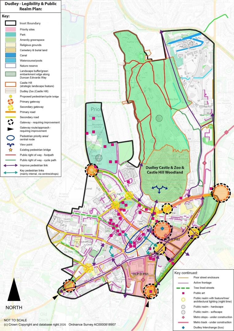
2.42The town’s character is greatly influenced by its public realm, with some locations in need of upgrading. Public open spaces provide a focus for community activity and form connections within the town centre.
Policy DLPD3 Public Realm in Dudley Town
- The quality of streets and open spaces will be improved through development or local initiatives having regard to the following measures:
- The provision of high-quality landscaping, floorspace material palette, furniture, lighting, signage and public art to help create a clear identity for the Town Centre.
Justification
2.43‘Public realm’ can be defined as all areas that the public have access to including streets, squares and open spaces. It is considered necessary to introduce greenery into the towns’ urban environment and resolve the competing needs of vehicles and pedestrians moving through the town centre. The quality of the public realm encountered, along with signage and legibility for visitors to understand and enjoy, is an important part in the role of the town centre.
2.44Key design principles for the public realm include:
- Quality of the Public Realm: increase the adaptability of spaces for future use; create legible spaces and routes that add to the ‘sense of place’ of an area; relate public spaces to surrounding buildings and vice-versa; and improve continuity and enclosure.
- Active Frontages: a common building line creates continuity of frontage and provides definition and enclosure to the public realm. Minimising set back distances increases the ability of a building to interact with the public realm. In the Town Centre buildings should be built adjacent to the pavement.
2.45Passive, active, and incidental open spaces play a significant role in urban design. These different types of open spaces within Dudley Town centre are crucial for creating liveable and vibrant communities. Passive spaces offer moments of tranquillity and respite, active spaces promote physical well-being and social interaction, and incidental spaces provide opportunities for leisure and engagement. Improving pedestrian links in Dudley town centre should take account of safety, accessibility, aesthetics, and the overall urban experience.
2.46Within the town centre, the Market Place forms a key central focus and major area of public realm which has been renewed through a high-quality public realm landscape project. New paving, brand new stalls, canopies, feature lighting and new street furniture, as well as the relocation of the Duncan Edwards Statue to a more prominent place at the New Street end of the market, creates a vibrant and attractive space at the heart of the town centre.
2.47Significant development projects, such as the campus buildings of Dudley College, have provided quality public realm. Stone Street and its connections via Priory Street and St James’s Road is a significant public space for Dudley. Wherever there is likely to be a concentration of people, major public spaces make a vital contribution to the structure of a town centre. Protection and enhancement of key squares and public open spaces within Dudley Town Centre is important to enhance activity and require high quality landscape treatment.
2.48At Castle Hill the public realm has undergone major investment and improvements. This assists in the development of the visitor economy and in particular an expansion in visitor numbers at the Zoological Gardens, The Black Country Living Museum and The Dudley Canal Trust as well as facilitating the development and regeneration of Dudley Town Centre as a centre for entertainment, leisure and recreation.
2.49There is the potential for the creation of new, high quality public realm in the town centre, particularly associated with the forthcoming Metro line and the individual Priority and Opportunity Sites. Where opportunities present themselves, the development of new ‘pocket parks’ should be encouraged for people to relax and enjoy the town centre.
Figure 2.3: Dudley Town Legibility and Public Realm Plan
Historic Environment
1.50The historic environment and heritage assets of Dudley Town will be conserved and enhanced as per Policies DLP54-DLP58. This section sets out the key characteristics of the Dudley inset plan area and the town-specific evidence base information for context, but no additional policy provisions to Policies DLP54-DLP58 are set out (other than in site specific allocations).
1.51The town of Dudley grew up around the foot of the castle and from the early medieval period up to the Civil War, Dudley changed little. In the 17th Century, Dudley saw a steady expansion due to the growth of coal mining and iron working. The largest expansion of Dudley as a settlement is however mainly attributed to the 18th and 19th centuries during the Black Country’s industrial heyday. Throughout this period of rapid expansion, Dudley kept its image as a bustling market town and today the marketplace is still a busy focal point located at the heart of the town centre.
1.52Perhaps the most important aspect of Dudley’s townscape lies in the survival of both the pattern of medieval streets and ‘entries’ and key landmarks such as the Castle and Zoo, Dudley Priory, the two town churches (both Grade II* listed) and the public monuments such as the Grade II* listed drinking fountain located in the centre of the Market Place.
1.53Accordingly, the Dudley Urban Historic Landscape Characterisation (UHLC) and Conservation Area Character Appraisals for Castle Hill and Dudley Town Centre have been prepared and provide an up-to-date evidence base for managing the planning of the town centre from a historic perspective.
1.54The historic importance of Dudley Town Centre is recognised as a major asset in delivering regeneration and enhancing the town centre as a tourist destination. Large parts of the inset plan area fall within either the Dudley Town Centre Conservation Area or the Castle Hill Conservation Area. In addition, there are three Scheduled Monuments (SMs) and the Priory Park (Registered Park and Garden).
1.55Listed buildings, Conservation Areas and all other presently known sites of archaeological or historic interest in Dudley are recorded in detail within the Historic Environment Record (HER) held by the Council. Developers should always consult the Dudley HER at the earliest possible planning stage and before considering any proposals for development which could adversely affect heritage assets.
1.56The UHLC provides the evidence base to inform an understanding of the town's historic character. All development proposals should be designed to reinforce and enhance local distinctiveness. Planning applications will be determined with particular reference to the contents and findings of the Dudley UHLC.
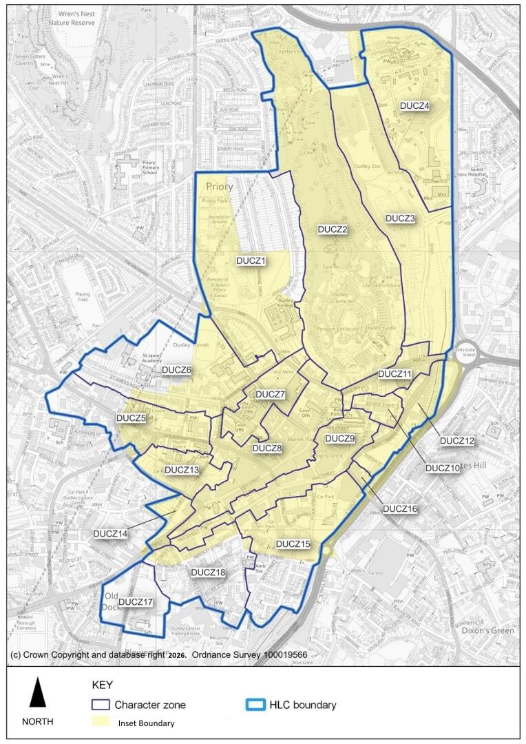
1.57The study describes the historical development of Dudley and identifies eighteen Historic Townscape Character Zones within the Town Centre and beyond (see plan below). For each Character Zone, individual buildings and areas have been identified, which contribute positively or otherwise to local character (designated and non-designated heritage assets). Where physical evidence of historic character persists in the form of heritage assets that make a positive contribution to local distinctiveness, such assets should be conserved and wherever possible enhanced (in line with national and local planning policy). Locally significant non-designated heritage assets include Areas of High Historic Townscape Value, Areas of High Historic Designed Landscape Value and Archaeological Priority Areas.
1.58In Dudley, it is considered that the whole extent of the medieval planned town should be an Archaeological Priority Area (APA) as identified on the Policies Map. In addition, there are also some specific sites associated with the glass industry such as the 18th century remains of the cone belonging to the former Dudley Flint Glass Works, now located below Stone Street Square, that are also worthy of their own status as an APA.
1.59The town centre has a high potential for the presence of significant archaeological remains dating from its medieval origins in the 12th century right through its development during early modern periods to its growth and expansion during the Industrial revolution. Dudley Council’s Historic Environment Record (HER) records sites in the inset plan area as having high potential for the survival of archaeological remains of regional or national importance but have yet to be designated. Dudley Council will consider the preservation of such archaeological remains when assessing planning applications, as well as identifying opportunities to make greater use of the archaeological resource in sustaining the area’s character and distinctiveness.
2.60Areas of High Historic Townscape Value (AHHTV) have been identified through the Dudley Borough wide UHLC on the periphery of the inset plan boundary within residential areas around Priory and Wrens Nest, Churchfield Street, West Dudley, Blowers Green and Kate’s Hill (as identified on the Policies Map and in Policy DLP57). The borough wide UHLC indicated that these areas exhibit a concentration of historic assets that make a positive contribution to local character and distinctiveness. As these areas represent historic settlement and suburban growth outside the town centre, it is important that routes are enhanced to these areas connecting with the town centre and new development.
Figure 2.4: Dudley Town UHLC Boundary and Character Zones
Dudley Town Centre Conservation Area
2.61Dudley Town Centre was designated as a Conservation Area in 2005 with updates made in October 2015. An updated Conservation Area Appraisal was adopted in 2015 and a Conservation Area Management Plan was adopted in 2017.
2.62The Town Centre Conservation Area reflects the medieval extent of the town and includes the marketplace and the 18th and 19th century expansion to the north including the civic quarter, St James’s Road and Ednam Road high quality housing. The relationship with the castle can still be appreciated in views from the town centre, although addressing connectivity between the two is a key objective. Buildings range in date from the 18th century to the present day and vary widely in style. Located throughout the Dudley Town Centre Conservation Area are a number of historic buildings which have heritage value (designated and non-designated assets).
2.63A Townscape Heritage Initiative scheme (THI) for the Dudley Town Centre Conservation Area has been in operation since 2008 (funded by the National Lottery Heritage Fund). Phase 1 of the scheme (2009-2015) saw an investment of £4million towards the repair and reuse of 17 properties such as The Crown Public House, the Old Co-op, Baylies Hall and the Old Glass House (which in 2017 received a finalists Award from the RTPI National Award for Excellence). Phase 2 of the scheme has funded repairs to several other buildings, including Plaza Malls and Fountain Arcade and 203/204 Wolverhampton Street (the former Merlin’s Bar).
2.64In combination with other strategic regeneration initiatives, such as the public realm work in Stone Street, Coronation Gardens, Castle Street and the Market Place, plus the work undertaken by Dudley College with the creation of the town centre campus, they have collectively led to a demonstrable improvement in the quality of the Town Centre Conservation Area. There are however elements within the Conservation Area that do not preserve or enhance the character and appearance of the Conservation Area. These have been identified in the Conservation Area Character Appraisal.
2.65The Dudley Town Centre Conservation Area Appraisal sets out the historic development of the Conservation Area and highlights those elements of the built or natural environment that contribute to its character and appearance. It also sets out the issues that currently have a negative impact on the Conservation Area and which need to be addressed. The Appraisal identified eight-character areas, each with their own individual and definable character which collectively creates a sense of place within the Dudley Town Centre Conservation Area. Planning applications will be determined with particular reference to the contents and findings of the Dudley Town Centre Conservation Area Appraisal and Management Plan.
Castle Hill Conservation Area
2.66Castle Hill was originally designated as a Conservation Area in 1975 with boundary updates made in 2005. An updated Conservation Area Appraisal was adopted in 2015.
2.67Castle Hill Conservation Area is an important area of townscape and landscape: an area of high historical, archaeological, geological, ecological, landscape, tourist and leisure value. It is primarily an area of open space and woodland stretching north to south and is located upon a large outcrop of Much Wenlock Limestone Formation strata deposited in the Silurian Period some 428 to 429 million years ago. The hill is a prominent geomorphological feature and icon of Dudley and the borough. The north of the Castle Hill is woodland which contains rock face exposures and ravines and provides a potentially valuable recreational resource as well as evidence of the Earl of Dudley’s network of carriage drives developed over the earlier mineral railways associated with the late 18th century limestone workings. It is the starting point for the borough’s ‘Limestone Way’ which starts at Castle Hill and runs to Wren’s Nest National Nature Reserve and Sedgley Beacon. It is also where Dudley Canal Trust provides access to the 18th century canal system which runs under Castle Hill.
2.68The imposing ruins and earthworks of the medieval castle, a Scheduled Monument and Grade I Listed Structure dominate the southern end of the hill, which is surrounded by the landscape and buildings of Dudley Zoological Gardens. This contains the listed collection of early 20th century Zoo buildings by the Tecton Partnership. The geological interest of Castle Hill is internationally renowned and there is a unique legacy of a well-preserved limestone quarrying landscape of national significance, designated a Scheduled Monument in 2004. It displays evidence of both surface and underground limestone working with associated canals, limekilns, caverns and other structures dating from the late medieval period throughout the Industrial Revolution until the modern era. Additionally, the hill possesses a wealth of important ecological features.
2.69The area of Castle Hill has been the subject of a ‘Vision’ (as outlined in Policy DLP D1) which have brought about a range of improvements to the Conservation Area; future developments associated with the Vision will need to continue to conserve and enhance its historic features (see Policy DLP D1 and other relevant national and local planning policies related to the historic environment).
2.70The Castle Hill Conservation Area Appraisal sets out the historic development of the Conservation Area and highlights those elements of the built or natural environment that contribute to its character and appearance. It also sets out the issues that currently have a negative impact on the Conservation Area and which need to be addressed. The Appraisal identified seven-character areas, each with their own individual and definable character which collectively creates a sense of place within the Castle Hill Conservation Area. Planning applications will be determined with particular reference to the contents and findings of the Castle Hill Conservation Area Appraisal.
Sustainable Transport and Active Travel
2.71Policies DLP63-DLP69 provide the strategic transport policies for the Borough. This section sets out key priorities for the Dudley inset plan area.
Policy DLPD4 Sustainable Transport and Active Travel in Dudley Town Centre
- Key schemes and priorities for sustainable transport improvements within Dudley town centre are identified on the Dudley Town Transport and Movement Plan and Policies Map. Development proposals within the town centre should ensure alignment with these schemes and provide connections to them to ensure opportunities for sustainable and active travel are maximised. Key schemes and priorities within the Inset Plan area are:
- New Interchange.
- Metro route and associated active travel improvements (including additional cycleways as detailed below).
- New cycleway links including along the A4123 (Priory Road to Tipton Road), the A4168 (A4123 south towards A459) and related to completion of the National Cycle Network route 54 through Dudley town (from A4123, via Trindle Road, King Street and Queens Cross).
- Regard should be had to active travel links beyond the Inset Plan area, including proposed cycle routes along the A461 (from Dudley Port via Burnt Tree).
Justification
2.72Dudley is a significant centre in the Black Country for a range of leisure, tourism and employment opportunities but further growth requires improvements to public transport, cycling and walking networks whilst facilitating opportunities for emerging innovations i.e., micro-mobility (small vehicles such as electric scooters).
2.73The existing Dudley bus station is being redeveloped to provide a modern transport interchange, aligned to the forthcoming Metro line and stops. This is conveniently located adjoining the Town Centre Core Area alongside Fisher Street and its redevelopment will improve customer experience, improve operational efficiency, and provide a high quality, modern gateway into Dudley Town Centre. It is expected to be completed by Spring 2025.
2.74Given that Dudley Town Centre has no direct access to the national rail network (with Dudley Port Station being approximately 2 miles away) the forthcoming Metro will have a key role in enhancing the accessibility for people travelling to and from Dudley Town Centre. In Dudley borough, the proposed Metro line provides a link from Castle Hill up into the Town Centre, adjacent to the bus station. The route then continues at street level along King Street and down Flood Street, and then continues west towards Brierley Hill. The Metro will also provide the borough with a connection to the national rail network at Wednesbury.
2.75The Metro is under construction, with parts of the scheme at Castle Hill and Flood Street well under way and near completion. It is expected that passenger services will commence at the end of 2024.
2.76There is a need to continue to safeguard the route as it remains under development and to enable future development sites within the town centre to reflect and complement the new Metro line, supporting economic regeneration and growth.
2.77Effective management of the Key Route Network (KRN) and its links to the Strategic Road Network (SRN) are integral in supporting increased investment and regeneration in and around Dudley Town Centre. Maintaining and improving the efficiency of the local road network will benefit commuters, visitors and public transport users by reducing congestion and providing more reliable journey times into and out of Dudley. Major Network Scheme improvements, including those to Burnt Tree junction are part of this management.
2.78The potential introduction of a 20mph zone covering the retail core of the Town Centre would align with national policy which places vulnerable road users at the top of the hierarchy by providing safer and enhanced environments for pedestrians. Furthermore, complementary traffic management measures, including improved pedestrian crossing facilities along primary thoroughfares would be incorporated into this 20mph zone scheme.
2.79Dudley Town Centre sits alongside the Sustrans National Cycle Network (NCN) Route 54 (Derby to Stourport), which links to Brierley Hill and Stourbridge to the southwest and NCN Route 81 (Aberystwyth to West Bromwich) to the northeast. NCN 81 links to both Coseley and Wolverhampton to the north and Birmingham to the south. In the Dudley central area the route of NCN54 is not currently well established, and it is therefore proposed to consider the most suitable route that will both clearly define the route of the NCN and also provide good access directly into the Town Centre. As part of the active travel improvements at Trindle Road and the A461, cycleway links will be improved between the town centre and Castlegate Park.
2.80Essentially a ‘hub and spoke’ ethos will be developed in Dudley Town Centre where placemaking efforts will be supported by a network of sustainable transport links to the Key Route Network (KRN), the Strategic Road Network (SRN) and the National Rail Network whilst also promoting accessibility to other local centres to raise Dudley’s offer to its businesses, residents and visitors.
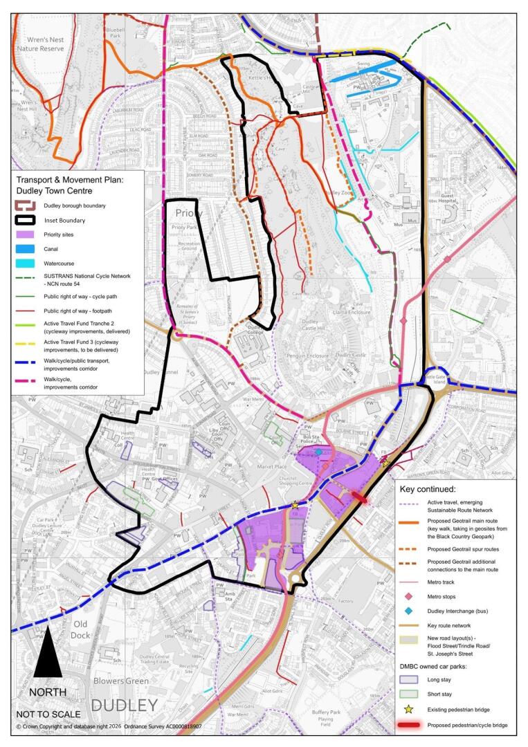
2.81Dudley Inset Plan area contains two of the Borough’s ‘Priority Sites’ at Flood Street/King Street and Trindle Road/Hall Street/Birdcage Walk (also known as ‘Portersfield’). In addition, four ‘Opportunity Sites’ have been identified where redevelopment and regeneration would provide benefits to the town centre. These represent mixed use sites, including residential development. The opportunity sites do not preclude or diminish the importance of investment or change elsewhere within the centre. They simply reflect the Council’s wish to prioritise use of its resources to kick start and progress projects which will have a significant regeneration impact and act as a catalyst for wider change.
2.82In addition, there are several sites identified for residential development within the Inset Plan area. These are identified within Policy DLP10 as part of the overall housing land supply as summarised below.
Table 2.2: Summary of Dudley Town Allocations
|
Site Name (and ref) |
Mixed Use |
Minimum Residential Capacity |
|---|---|---|
|
Priority Sites |
||
|
Flood Street/King Street (DLP D PS1) |
Yes |
120 dwellings |
|
Trindle Road/ Hall Street/Birdcage Walk (DLP D PS2) |
Yes |
330 dwellings |
|
Opportunity Sites |
||
|
Tower Street/Castle Street (DLP D OS1) |
Yes |
40 dwellings |
|
Trident Centre/Upper High Street (DLP D OS2) |
Yes |
60 dwellings |
|
Upper High Street/King Street (DLP D OS3) |
Yes |
40 dwellings |
|
Abberley Street/King Street (DLP D OS4) |
Yes |
50 dwellings |
|
Housing Allocations |
||
|
Regent House, King Street (DLP D H1) |
No |
18 dwellings |
|
BT Telephone Exchange, Trinity Road/Wolverhampton Street (DLP D H2) |
No |
70 dwellings |
|
Dudley College/ Wolverhampton Street Car Park (DLP D H3) |
No |
28 dwellings |
|
Royal Mail Sorting Office, Trinity Road (DLP D H4) |
No |
15 dwellings |
|
200a Wolverhampton Street (DLP D H5) |
No |
22 dwellings |
|
Tipton Road- land adjacent to Black Country Museum (DLP D H6) |
No |
35 dwellings |
|
Appleyard Site, Wolverhampton Street (DLP D H7) |
No |
18 dwellings |
2.83A Policy is provided for each Priority and Opportunity site which identifies the acceptable uses. For the Priority Sites, key design principles are included within the policy; for the Opportunity Sites these are provided as part of the Local Plan evidence base. The design principles are based on an assessment of land use, access and movement, layout and form, scale and mass, character and appearance and landscape and public realm. They particularly reflect the heritage and character of Dudley and demonstrate how the ambitions for these sites could be developed in a way that respects good design principles. All of the Dudley Town Centre Priority and Opportunity Sites are either within or adjacent to the Dudley Town Centre Conservation Area. The Local Plan policies and evidence base related to historic character and heritage assets will inform the appropriate design of all development sites coming forward within the town centre.
2.84Several of the housing allocations outlined above are located along the Wolverhampton Street, creating a ‘corridor’ of change towards residential development that could serve to help regenerate this part of the town centre.
2.85It is recognised that the residential capacity of DLP D PS2 (Trindle Road/Hall Street/Birdcage Walk) may vary dependent on the nature of developments to be delivered across the site parcels e.g., the mix of apartments and houses. This could result in a range of circa 300-400 dwellings being delivered, and the 330 dwellings is identified as an indicative figure which is not a cap.
Policy DLPDPS1 (Priority Site) Land at King Street/Flood Street
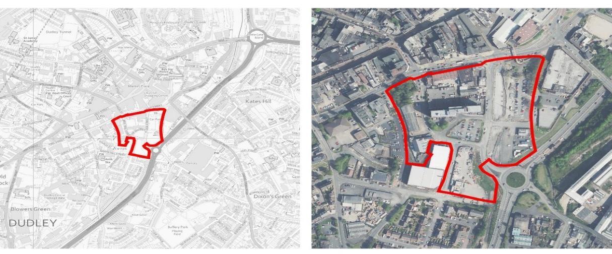
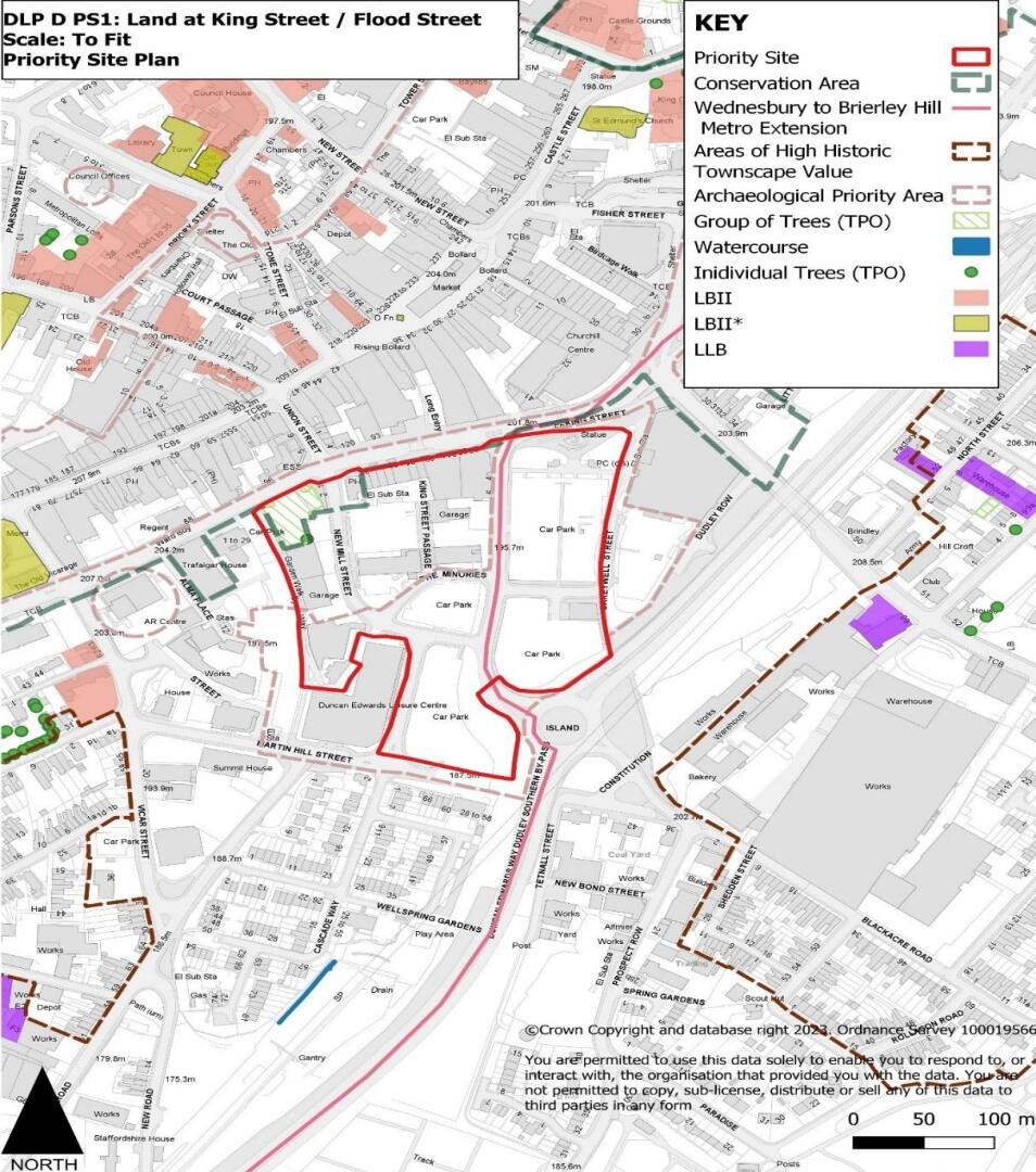
- This site is allocated for mixed use redevelopment, including housing. The site should deliver a minimum of 120 dwellings.
- This site is bounded to west by the recently completed Duncan Edwards Leisure Centre and associated car park, to the north by King Street (with an existing retail frontage) and to the south by Martin Hill Street and Duncan Edwards Way (Dudley Southern Bypass). There is an existing retail frontage to King Street which would benefit from enhancements along this key route and gateway to the town. The area is dominated by large areas of surface car parking (currently out of use whilst the Metro line is under construction).
- There is a former office building, Falcon House, which has since been converted to a residential use occupying a key location between Flood Street and New Mill Street. Existing properties on site are occupied by various uses, including a furniture store, car wash and car repair garage. To the west of New Mill Street is an historic churchyard as well as several historic and more modern buildings. There is modern residential estate to the south of the site.
- The north-western part of the site fronting King Street (existing retail frontage) is within the Town Centre Core Area. The new Metro line will pass along Flood Street, with a new Metro stop and associated public realm provision to provide connections into the town centre. Leisure uses in this location would complement the existing Duncan Edwards Leisure Centre, providing a ‘hub’ for such activities adjacent to sustainable transport links (alongside other main town centre uses). Higher density residential development would complement existing residential provision nearby and would also maximise the benefits of the Metro stop on this site.
- The site is largely adjacent to the Dudley Town Centre Conservation Area with a part of the site along the King Street frontage falling within it. In the context of the Urban Historic Landscape Characterisation the opportunity site falls within two character zones, Character Zone 9 (Dudley King Street and Prospect Hill) and Character Zone 15 (Flood Street Car Parks and Offices Complex).
- Delivery phasing of dwellings and any other development: Mixed use redevelopment of the site including,
- Class E uses (excluding E(g)(ii) and E(g)(iii)), Drinking Establishments/Public Houses, Cinemas, Class F1(b-e) uses, Theatres and venues for live music at the ground floor within the Town Centre Core Area, in accordance with Policy DLP24 (including consideration of convenience retail).
- To complement existing indoor leisure provision nearby, Class E (d) Indoor sport, recreation or fitness, Class F2 (c) Areas or places for outdoor sport or recreation and Class F2 (d) Indoor or outdoor swimming pools or skating rinks (outside the Town Centre Core Area, in accordance with Policy DLP24).
- Complementary appropriate uses outside of the Town Centre Core Area but within the town centre boundary (in accordance with Policy DLP24).
- Residential development, in accordance with Policy DLP24. Indicative capacity of a minimum of circa 120 dwellings, but this is not a cap and capacity could vary as part of any mixed-use development of the site.
- Car parking – proposed development will need to cater for its own needs and assess the need to cater for any displaced public car parking or removal of parking that facilitates the development.
- Proposals to take account of and complement forthcoming Metro route/stop and associated public realm provision.
- Phasing: 2031/32 – 2033/34 - 120 dwellings
- This policy sets out the spatial framework and specific policy requirements – other standard policy requirements will also apply as set out in the DLP.
- Details of site ownership: There is mixed ownership of the site, including Council ownership (large proportion of the site) and individual private ownership.
- Impact on infrastructure provision:
- School place impacts
- Analysis suggests that education infrastructure needs arising from theDLPgrowtharelikelytobeaccommodatedviaexpansionstothe current school estate as opposed to the creation of new school(s). However due to the DLP plan period extending beyond current education forecasts this analysis would be ongoing, and contributions may be required.
- Highways impacts
- The site is highly accessible and has direct access to numerous alternatives to private car use, any proposals must provide high quality access to active modes whilst restraining high levels of car parking at the site and its possible displacement to nearby areas. VehicularaccessisavailableoffKingStreetviaexistingFloodStreet andNewMillStreet.Thenumberofaccesspointsrequired,andtheir design should be subject to further detailed transport assessment (that has been scoped and developed in consultation with the Council) and is dependent upon the nature of any proposed developmentscheme.Regardtobehadtotheremodelledroadlayout onsitetofacilitatetheforthcomingMetroroute/stopandsafeguarded route for future Metro extension. A key part of the site layoutshould beconnectionstothecyclingandwalkingnetworkwithinandaround thetowncentre.Retain,improveandintegratenewdevelopmentwith theexistinghistoricfootpath,GardenWalkandpedestrianroutefrom Duncan Edwards Way to King Street.
- Biodiversity net gain
- There are no designated nature conservation assets on this site. Policy DLP32 will apply.
- Recreational open space requirements
- It will be necessary for the site to provide for and connect to good-quality walking and cycle routes that provide easy, quick and safe accesstonearbyopenspacesandparkswithinandaroundthetown centre and at Castle Hill.
- Drainage
- Sustainable drainage systems that are sufficient to achieve greenfieldrunoffratesshouldbeprovidedforthesite,inaccordance with Policy DLP45.
- Historic Environment
- Dudley Town Centre Conservation Area is directly adjacent to the northern site boundary (King Street) and covers a small part of the site.Part of the site is an Archaeological Priority Area (FloodStreet).There are several HER records on and adjacent to the site, including 1&2 New Mill Street (HER 15181), the site of the former UnitedReformChurchandGraveyard(HER984),YeOldFoundryPH, King Street (HER 15065), New Mill Street (HER 4963) and the ‘Churchill’ family sculpture (HER 15180). Views to the Castle Hill Conservation Area to the northeast of the site also require consideration. The overall design approach should positively contribute to the setting of the Dudley Town Centre Conservation Area and adjacent heritage assets. Regard to be had to views into and out of the Dudley Town Centre Conservation Area and potential impact on heritage assets (refer to Landmarks, Views, Vistas and Gateways Plan in particular SV3, PV3 and EG4.) The Dudley Town Centre Urban Historic Landscape Characterisation (UHLC) identifies that the site is located within Character Zone 9 (Dudley King Street and Prospect Hill) and Character Zone 15 (Flood Street Car Parks and Offices Complex). The UHLC describes in detail this area identifying the issues and sensitivity to change, the key heritage assets to be considered and more importantly the potential opportunities and priorities for enhancement, full reference to this information will be expected when formulating proposals for this site and when preparing Heritage and Design and Access Statements. A TPO area to the northwest corner of the site should be preserved to contribute to the amenity value of the area and character of the Conservation Area. The potential for appropriate enhancements to this area will be considered further.
- Design principles:
- New development at this location will represent higher density development (minimum of 100dph but parts of the site would be appropriate for even higher density development). The new development will retain a network of public open spaces across the site with a sustainable urban environment, including adaptable buildings and spaces to support a range of different activities and uses over time. The buildings and spaces within the development should be adaptable to accommodate various activities and use over time. To ensure permeability, the layout should connect to the surrounding vehicle roads, pedestrian routes, and metro stop with a public open space network and tree-lined streets running North-South and East-West. Additionally, the layout must also incorporate areas reserved for Midlands Metro Alliance (MMA) and the metro stop.
- The part of the development facing King Street should have a relatively solid edge and respectable height to improve its visual significance, enhance and respect the designated conservation area opposite the site, and increase activity and footfall along the street and within the priority site. As for the parcel located in the southeast, taller buildings are more suitable due to the topography and location of the area. These buildings should serve as a focal point and identity to the surrounding sites opposite the metro stop and along Duncan Edwards Way. It is acceptable for a much higher density development to be located in this parcel (in excess of 100dph). Developments should ensure that the layout and design is informed by a Landscape and Visual Impact Assessment (LVIA) / Landscape Visual Appraisal (LVA).
- School place impacts
Policy DLPDPS2 (Priority Site) Land at Trindle Road / Hall Street / Birdcage Walk (Portersfield)
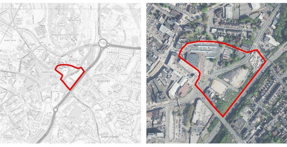
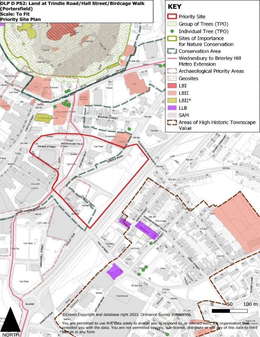
- This site is allocated for mixed use redevelopment, including housing and a new transport interchange. The site should deliver a minimum of 330 dwellings
- This site is located to the southeast of the town centre and adjoins Duncan Edwards Way. It is partly located within the Town Centre Core Area. It is bounded on the north by Fisher Street, Birmingham Street and Trindle Road and Hall Street to the southwest. The Churchill Shopping Centre is located to the west and the bus station (due to be redeveloped) to the north. Located on the outside of the Churchill Shopping Centre is Birdcage Walk which has small ground floor retail units with first floor ancillary accommodation. There are several vacant properties located within a triangle of land between Trindle Road and St Joseph’s Street. The area to the south of Trindle Road has been largely cleared in recent years, formerly occupied by office and retail buildings. Smaller scale properties occupied by a mix of retail and commercial uses, along with vacant premises front areas along Trindle Road and Hall Street. A car sales operation lies along Claughton Road North.
- The forthcoming Interchange and Metro stop provide an opportunity for higher density residential development at this location, maximising the benefits of the sustainable transport links. There is also the opportunity for the provision of complementary main town centre uses, linking into the wider Town Centre Core Area and providing an active frontage to the Interchange and nearby town centre uses. The public realm associated with the new Interchange, Metro, active travel links and overall redevelopment of the site should play a key role as a ‘welcoming arrivals and destination space’.
- A large proportion of this site falls within the Dudley Town Centre Conservation Area and given its elevated position within the Town it provides key views to and from the Castle Hill Conservation Area and especially to nearby St Edmunds Church. Within the context of the Urban Historic landscape Characterisation (UHLC) the site falls within three character zones; Character Zone 9 (Dudley King Street and Prospect Hill); Character Zone 12 (Trindle Road, Commercial and Office Buildings); Character Zone 16 (Hall Street). Also identified in the UHLC are two Archaeological Priority Areas (APA); the Medieval Planned town of Dudley and the site of Phoenix Glassworks.
- Delivery phasing of dwellings and any other development:
- Residential-led development of the site including:
- Class E uses (excluding E(g)(ii) and E(g)(iii)), Drinking Establishments/Public Houses, Cinemas, Class F1(b-e) uses, Theatres and venues for live music at the ground floor within the Town Centre Core Area (particularly to provide a ground floor active frontage to the new Interchange), in accordance with Policy DLP24 (including consideration of convenience retail).
- Residential redevelopment, in accordance with Policy DLP24. Indicative capacity of circa 330 dwellings, but this is not a cap and capacity could vary as part of any comprehensive development of the site.
- Complementary appropriate uses outside of the Town Centre Core Area but within the town centre boundary (in accordance with Policy DLP24) may be provided, as appropriate to complement the residential development, but this would be of a small scale.
- A new transport interchange will be delivered on the current bus station site, complementing the forthcoming new Metro line along Trindle Road and passing through the site.
- Residential-led development of the site including:
- Phasing:
- 2029 – 2030: 60 dwellings
- 2030 – 2031: 60 dwellings
- 2031 – 2032: 70 dwellings
- 2034/35 – 2038/30: 140 dwellings
- This policy sets out the spatial framework and specific policy requirements – other standard policy requirements will also apply as set out in the DLP.
- Details of site ownership: There is mixed ownership of the site, including Council ownership and individual private ownership.
- Impact on infrastructure provision:
- School place impacts
- Analysis suggests that education infrastructure needs arising from the DLP growth are likely to be accommodated via expansions to the current school estate as opposed to the creation of new school(s). However due to the DLP plan period extending beyond current education forecasts, this analysis would be ongoing, and contributions may be required.
- Highways impacts
- The sustainability of this site was included within a local cordon model produced to support the regeneration of Dudley Town Centre; a predominantly residential development at this site presents the most sustainable solution. The site is highly accessible and has direct access to numerous alternatives to private car use, any proposals must provide high quality access to active modes whilst restraining high levels of car parking at the site and its possible displacement to nearby areas. Existing access points off Trindle Road. The number of access points required, and their design should be subject to a further detailed transport assessment (that has been scoped and developed in consultation with the Council) and is dependent upon the final detail of the proposed development scheme. Proposals need to accommodate and integrate with the future Metro route (including a segregated cycleway to Trindle Road); provide good legible and easily achievable pedestrian and cycle routes between the eastern and western edges; include improved local connections to Dudley Castle and Zoo from the town.
- Biodiversity net gain
- There are no designated nature conservation assets on this site. Policy DLP32 will apply.
- Recreational open space requirements
- It will be necessary for the site to provide for and connect to goodquality walking and cycle routes that provide easy, quick and safe access to nearby open spaces and parks within and around the town centre and at Castle Hill.
- Drainage
- Sustainable drainage systems that are sufficient to achieve greenfield runoff rates should be provided for the site, in accordance with Policy DLP45.
- Historic Environment
- Northern and western part of the site lie within Dudley Town Centre Conservation Area. Archaeological Priority Areas also on western and northern parts of site. Listed buildings adjacent to site boundary include St Thomas and Our Lady Church (Grade II), St Edmunds Church (Grade II*) and Castle Hill Conservative Club (Grade II). There are several HER records, including Metro Bar, Trindle Road (HER 12898). Given the site’s elevated position there are key views to and from the Castle Hill Conservation Area (and Dudley Castle Scheduled Ancient Monument). The overall design approach should positively contribute to the setting of the Conservation Areas and adjacent heritage assets. New development needs to ensure the following views, landmarks and gateways are protected and where necessary improved as shown on the Landmarks, Views, Vistas and Gateways Plan: SLP1, SK6, PV1, SV1, SLP3, IG2, EG2 and EG6).
- The Dudley Urban Historic Landscape Characterisation (UHLC) identifies that the site is located in Character Zone 9 (Dudley King Street and Prospect Hill); Character Zone 12 (Trindle Road, Commercial and Office Buildings); Character Zone 16 (Hall Street). The Dudley Town Centre Conservation Area Appraisal and the Dudley UHLC describe in detail this area identifying the issues affecting it and its sensitivity to change, the key heritage assets to be considered and, more importantly, the potential opportunities and priorities for enhancement. Full reference to this information will be expected when formulating proposals for this opportunity site and when preparing Heritage and Design and Access Statements.
- Within this site and identified in the UHLC are two Archaeological Priority Areas (APA); the Medieval Planned town of Dudley and the site of Phoenix Glassworks. Accordingly, the archaeological potential of the site will need to be addressed as part of the planning application process in advance of determination of applications for this site. Whilst limited archaeological desktop assessments have been undertaken within certain parts of the site, further assessment will be required, tailored to the specific proposals being brought forward.
- Design principles
- Due to the topography and extensive views from the site towards several notable landmarks, including Dudley Castle and Top Church, the roofscape and elevations of any new development in this area will be highlighted prominently in views out from the castle and will need to be of high quality to enhance the castle’s setting.
- The existing urban grain and scale of buildings around the site are between 2 and 4 storeys, so any new development should generally be between 3 and 4 storeys high for residential purposes. The area has a complex topography sensitive to development; therefore, the scale of the buildings in the area should be adjusted to fit the terrain. However, some parts of the sites could, subject to the right design and the appropriate level of supporting information, accommodate taller buildings. The new development is expected to have a minimum density of 100ph overall, which will vary across the site parcels according to the type of development and housing provided. Developments should ensure that the layout and design is informed by a Landscape and Visual Impact Assessment (LVIA) / Landscape Visual Appraisal (LVA).
- The impact of the development on the character and appearance of the Conservation Area, adjacent Grade II listed church, and views into and out of the area should be considered. The design and appearance of the development should respond to the existing layout of buildings, streets, roads, and spaces. The historical connection between Porter Street and Porter Street South should be safeguarded, allowing for eventual reconnection through a new pedestrian footbridge that will catalyse the Kates Hill neighbourhood and connect the area to Dudley Town Centre.
- The development should provide a series of perimeter blocks that integrate and improve connections to the existing urban structure with an active frontage onto the public realm. A highly permeable and well-connected layout prioritising pedestrian and cycle users to and from the town centre, metro stop, and bus interchange is essential. To provide an appealing and safe pedestrian experience, mixed use development, especially near the metro stop, are crucial.
- School place impacts
2.86A Development Brief (adopted March 2024) has been prepared that sets out site-specific principles to guide future development proposals at this site. This reflects the key principles of this policy. The brief will be a material consideration when assessing detailed proposal for the site.
Dudley Town Centre Opportunity Site 1: Tower Street/Castle Street
2.87This opportunity site is centrally located in the historic core of the Dudley Town Conservation Area to the north of the Market Place and is focused on Tower Street and Castle Street. The area is partly comprised of surface level car parking. The buildings fronting Castle Street are currently occupied by a range of town centre uses, including the Dudley Council Plus services. To the west of the site on the opposite side of Tower Street, is the locally listed former fire Station which now forms part of the Dudley College Evolve building. To the north of the site is the Grade II Listed Baylies Hall. To the south of the site is the 1930s Court House Public House designed by A T Butler and to the east of the site is Castle Street. The site is in close proximity to the forthcoming new Interchange and Metro stop at Fisher Street.
2.88The part of the site fronting onto Castle Street is within the Town Centre Core Area, offering the potential for uses that continue to provide an active frontage at the ground floor. The part of the site fronting onto Tower Street offers the opportunity for other town centre uses. The site has good links to the nearby forthcoming Interchange and Metro stop. Residential development could come forward as part of any mixed-use redevelopment scheme (in accordance with Policy DLP24). Dependent upon the nature of individual development proposals, the impact upon public car parking may require consideration. Any loss of parking could affect the attractiveness of the town to inv``estors and an element of parking will therefore need to be re-provided for within the redevelopment of this site.
2.89Consideration needs to be given to the impact of proposals within the opportunity site on the significance and setting of heritage assets both on-site and within the vicinity, including Dudley Castle. Heritage Statements and Design and Access Statements accompanying proposals will be required to make reference to the Dudley UHLC and the adopted Conservation Area Appraisals. The opportunity site is located within the Dudley Town Centre Conservation Area and is within close proximity of the Castle Hill Conservation Area therefore special attention will be given to preserving and enhancing the character and appearance of the conservation areas and key views into and out of them. Located at the end of Tower Street is a clearly defined/framed view of the ‘Tower’ of Dudley Castle, a Grade I Listed Building as well as a Scheduled Monument and this along with the Grade II* Listed St Edmunds Church will be of key consideration when assessing the impact of proposals on key views and skylines.
2.90Being located within the core of the medieval planned town of Dudley, in an area identified within the Dudley UHLC as an Archaeological Priority Area (APA) there is a high potential for archaeological remains from the medieval period through to the Industrial period, accordingly the archaeological potential of the site will require detailed consideration. An archaeological desktop assessment and an archaeological evaluation have been undertaken on the site by the Council and whilst this information will be made available, it is anticipated that further assessment will be required.
Policy DLPDOS1 Dudley Town Centre Opportunity Site: Tower Street / Castle Street
Acceptable Land Uses
- Mixed use development including:
- Class E uses (excluding E(g)(ii) and E(g)(iii)), Drinking Establishments/Public Houses, Cinemas, Class F1(b-e) uses, Theatres and venues for live music at the ground floor within the Town Centre Core Area fronting Castle Street, in accordance with Policy DLP24 (including consideration of convenience retail).
- Residential development or conversion at the upper floors, in accordance with Policy DLP24. Indicative capacity of 40 dwellings, but this is not a cap and capacity could vary as part of any mixed-use development of the site.
- Complementary appropriate uses outside of the Town Centre Core Area but within the town centre boundary (in accordance with Policy DLP24).
- New redevelopment proposals should undertake a review of the impact on town centre public car parking and consider any parking implications as a result of the development proposals.
Dudley Town Centre Development Opportunity Site 2: Trident Centre/Upper High Street
2.91This opportunity site is located between Upper High Street, Wolverhampton Street and Inhedge Gardens (also known as Horseley Gardens). The area is focused on the Trident Centre, a purpose-built shopping precinct dating from the 1960s, the retail frontage along Upper High Street, and Inhedge Gardens which is one of the key areas of open space within the town centre.
2.92The Trident Centre comprises a purpose-built covered shopping centre together with a parade of shops fronting High Street, basement public car park, roof deck private car park, loading areas and office accommodation. It is a substantial area containing retail units and the centre can be accessed via High Street towards St. Thomas’s Church and Wolverhampton Street. The principal access to the shopping centre is from High Street.
2.93There is potential for the upper floors of the existing Trident Centre to be converted into residential use and for a more attractive, active edge be created for the elevations that overlook the Inhedge Gardens. A large proportion of the site (represented by the Trident Centre) lies within the Town Centre Core Area and whilst retail uses currently dominate, there is potential for repurposing of the Trident Centre for other appropriate uses, including leisure and food and drink. Any redevelopments should continue to provide an active frontage onto the High Street.
2.94Opportunities should be explored to provide the Old Meeting House with an enhanced setting with pedestrian access enhanced through and around the Inhedge by improving natural surveillance. Inhedge Gardens should be restored and enhanced by public realm improvements, including further landscaping. Also, the possibility of providing continuous linked Green Network e.g. Public Open Spaces, utilising the existing areas of public open space, in front of the Magistrates Court should be explored.
2.95The opportunity site falls within the Dudley Town Centre Conservation Area and within the context of the Urban Historic Landscape Characterisation (UHLC) the opportunity site falls within two-character zones: Character Zone 8 (Dudley Historic Core) and Character Zone 13 (Stafford Street and Inhedge). The Dudley Town Centre Conservation Area Appraisal and the Dudley UHLC describe in detail this opportunity area identifying the issues and sensitivity to change, the key heritage assets to be considered and, more importantly, the potential opportunities and priorities for enhancement: full reference to this information will be expected when formulating proposals for this opportunity site and when preparing Heritage and Design and Access Statements.
2.96Within this opportunity site and identified in the UHLC is the Medieval Planned Town Archaeological Priority Area (APA). Accordingly, the archaeological potential of the site will require detailed consideration.
Policy DLPDOS2 Dudley Town Centre Opportunity Site: Trident Centre / Upper High Street
Acceptable Land Uses
- Mixed use development including:
- Class E uses (excluding E(g)(ii) and E(g)(iii)), Drinking Establishments/Public Houses, Cinemas, Class F1(b-e) uses, Theatres and venues for live music at the ground floor within the Town Centre Core Area in accordance with Policy DLP24 (including consideration of convenience retail).
- Residential redevelopment or conversion at the upper floors, in accordance with Policy DLP24. Indicative capacity of 60 dwellings, but this is not a cap and capacity could vary as part of any mixed-use development of the site.
- Complementary appropriate uses outside of the Town Centre Core Area but within the town centre boundary (in accordance with Policy DLP24). Inhedge Gardens is currently an underused greenspace and pedestrian link into the Town Centre Core Area which will be protected and enhanced through public realm improvements. Direct links between High Street and Inhedge should be considered as part of any redevelopment proposals. Active frontages to Inhedge should be considered as part of any redevelopment proposals.
Dudley Town Centre Opportunity Site 3: Upper High Street / King Street
2.97This opportunity site forms the southwest ‘Gateway’ to Dudley Town Centre and is focused on the junction of High Street and King Street. The premises along High Street are a mix of town centre uses, with some vacant properties. Northgate House (fronting High Street with the rear extending to King Street) represents a modern development within a largely traditional street scene and offers the potential for some redevelopment. There is a motorcycle showroom on King Street (which appears to be in use for storage primarily) and some vacant properties.
2.98The southwest Gateway area is an important approach into the town centre and redevelopment should enhance and strengthen the sense of arrival into Dudley. The site is located outside the Town Centre Core Area. There is an emphasis on the residential repurposing of the area, alongside appropriate main town centre uses at the ground floor level. A mix of retention and refurbishment of existing buildings together with selective redevelopment opportunities will be supported.
2.99Being located within the Town Centre Conservation Area and given that there are several buildings recognised as Heritage Assets, the upgrading of buildings would have to be sensitive and responsive in terms of design. The views into and out from the town centre at this site could be enhanced and development adjacent to the Grade II* Listed St Thomas’s church should be appropriate so as not to detract from the setting of the church and its surroundings. Within the context of the Urban Historic Landscape Characterisation (UHLC) this opportunity site falls within, Character Zone 8 (Dudley Historic Core). Full reference to this information will be expected when formulating proposals for this opportunity site and when preparing Heritage and Design and Access Statements.
2.100New development should respect existing building lines, create good street enclosure and maintain a vertical rhythm that enhances the overall character of the area. With the approach of encouraging residential development in this site by ‘living above the shop’, small high quality amenity spaces could also be incorporated where appropriate.
2.101Within this opportunity site and identified in the UHLC is the Medieval Planned Town Archaeological Priority Area (APA), accordingly the archaeological potential of the site will require detailed consideration. In 2007 the Council commissioned Worcestershire Archaeology Service to prepare a Desk-based Assessment and Building Recording of the South-West Gateway and this information will be made available to developers when assessing the potential development opportunities. It is however anticipated that further assessment will be required for site specific proposals.
Policy DLPDOS3 Dudley Town Centre Opportunity Site: Upper High Street / King Street
Acceptable Land Uses
- Residential-led development including:
- Residential reuse of retained buildings and residential redevelopment. Indicative capacity of 40 dwellings, but this is not a cap and capacity could vary as part of individual proposals.
- Complementary appropriate uses outside of the Town Centre Core Area but within the town centre boundary (in accordance with Policy DLP24). This is anticipated to comprise of primarily ancillary Class E uses at ground floor level to complement residential development and provide a continued active frontage in this gateway location.
Dudley Town Centre Opportunity Site 4: Abberley Street/King Street
2.102This opportunity site also forms part of the southwest ‘Gateway’ into the town centre along with Opportunity Site 3 and is located between King Street and Abberley Street. It is currently a mixed-use area comprising of car parking area, a former training centre (occupied by a community use) and a range of other community and commercial uses. It is bounded by residential development to the south and west.
2.103The site is located outside the Town Centre Core Area. Similar to Opportunity Site 3, there is potential for primarily residential redevelopment alongside any appropriate main town centre uses. Opportunities exist for a much stronger built form in this block along Abberley Street and King Street. Pedestrian linkages should be strengthened into the town centre and opportunities for walking and cycling should be encouraged.
2.104A small part of the opportunity site falls within the Town Centre Conservation Area and within the context of the Urban Historic Landscape Characterisation this opportunity site falls within two Character Zones: Character Zone 9 (Dudley King Street and Prospect Hill) and Character Zone 18 (Churchfield Street, 19th Century Residential Area.) There are a number of existing historic buildings within this block and some of the historic street patterns remain intact.
2.105One of the gap sites requiring redevelopment is located on the corner of King Street and Vicar Street: the former 19th century burial ground belonging to St Thomas’s Church. A previous desk-based assessment of the site was undertaken where it was concluded that further archaeological investigation would be required. With regards to the rest of the opportunity site it is anticipated that further archaeological assessment will be required for site specific proposals.
Policy DLPDOS4 Dudley Town Centre Opportunity Site: Abberley Street / King Street
Acceptable Land Uses
- Residential-led development including:
- Residential reuse of retained buildings and residential redevelopment. Indicative capacity of 50 dwellings, but this is not a cap and capacity could vary as part of individual proposals.
- Complementary appropriate uses outside of the Town Centre Core Area but within the town centre boundary (in accordance with Policy DLP24). This is anticipated to comprise of primarily ancillary Class E uses at ground floor level to complement residential development and provide a continued active frontage in this gateway location.
Evidence
- Black Country Centres Study (2020, 2021, 2022 and 2024)
- Black Country Historic Landscape Characterisation (2010)
- Black Country Historic Landscape Characterisation Study (2019)
- Borough-Wide Urban Historic Landscape Characterisation Study (2016)
- Castle Hill Conservation Area Appraisal (2015)
- Castle Hill Vision (2019)
- Dudley Town Centre Conservation Area Appraisal (CAMP) (2017)
- Portersfield Development Brief (2024)
- Dudley’s Historic Environment Record (HER)
- Dudley Town Centre Urban Historic Landscape Characterisation (2015)
- Dudley People’s Panel - feedback on Dudley town centre (2019)
- Historic Environment Supplementary Planning Document (2017)
- Site Assessment Report (2024)
- Heritage Impact Assessment – Dudley Local Plan (2024)
- Dudley Economic Regeneration Strategy (2024)
- Dudley Cultural Strategy (2024)
Delivery
- Historic Landscape Characterisation documents
- Adopted Conservation Area Character Appraisals
- Development Management process including Design and Access Statements and Statements of Heritage Significance
- Supplementary Planning Documents
- A regularly updated and maintained Historic Environment Record (HER).
Figure 2.6: Dudley Inset Plan