

Dudley Local Plan Part Two
1. Brierley Hill Strategic Centre
Introduction
1.1This chapter sets out how Brierley Hill Strategic Centre will develop and change over the plan period. A vision for Brierley Hill is set out which will be delivered through the Local Plan polices and site allocations up to 2041. This chapter elaborates on the policies set out in Part One of the Dudley Local Plan by providing specific policies relevant to Brierley Hill Strategic Centre. This chapter should be read primarily in conjunction with Chapter 10 (Centres and Town Centre Uses) within Part One, along with other relevant Part One policies as applicable to individual proposals.
1.2Brierley Hill Strategic Centre lies within Regeneration Corridor Two, which covers Dudley, Brierley Hill, and Stourbridge and includes the proposed new Metro line route. This network will provide first class access to the rest of the Black Country and to Birmingham. The Local Plan expects that development in this corridor will focus on high-quality housing in and around the market town centres of Dudley and Stourbridge and the Strategic Centre of Brierley Hill, whilst preserving and enhancing the historic features and heritage assets within each centre. It is also intended that the corridor will have excellent green infrastructure through enhanced green spaces and parks, increased tree cover, and better links to Saltwells and Fens Pool Nature Reserves.
The Brierley Hill Inset Plan Boundary
1.3This inset chapter covers Brierley Hill Town Centre and its Conservation Area and also encompasses Merry Hill Shopping Centre and its surrounding area. The Brierley Hill Strategic Centre boundary and Town Centre Core Area boundaries are identified on the Brierley Hill Inset Policies Map. The Brierley Hill Inset boundary is a wider area than the designated town centre boundary and includes a number of adjoining areas where there are opportunities for new growth or redevelopment as well as including areas of open space to increase access and connectivity to these areas, including Chapel Street Housing Estate, The Delph Locks Conservation Area, Saltwells Wood and Northmoor Industrial Estate.
Vision and Objectives
Brierley Hill in 2041, as the borough’s Strategic Centre, will be a place which has the benefit of:
- having strong, resilient, and thriving communities with enhanced health and well-being, including access to more cultural, leisure and community facilities.
- being more than a shopping destination, including benefiting from a revitalised night-time economy and family orientated leisure facilities.
- having a greater resident population, proud to live in Brierley Hill, and living in sustainable, well-built and enhanced accommodation incorporating energy efficiency measures and making active use of extensive areas of imaginatively landscaped and well-connected public spaces.
- being a much greener place, with increased tree cover and more biodiversity including wildlife corridors, which are better linked to the Saltwells and Fens Pool Nature Reserves.
- being much more accessible, especially by public transport and a network of footpaths and cycleways, with the Midland Metro Stations providing focal points within these networks and hubs for new development, with well-designed public open spaces around them.
- having a high quality and beautiful built, natural, and historic environment that respects and enhances local character, including important historic buildings and areas, and makes effective use of the canal network as an asset.
1.4The vision is underpinned by the following specific objectives for Brierley Hill Strategic Centre:
- To enable Brierley Hill Strategic Centre to be more than a shopping destination with an emphasis on providing for the delivery of:
- New development centred around the proposed new transport infrastructure,
- The introduction of new high-quality, well-being enhancing and child-friendly housing environments
- The creation and enhancement of well-linked community, leisure and recreation spaces
- The consolidation of office uses
- The diversification of land uses within the centres
- To make full use of the place shaping opportunities presented by:
- The green and blue infrastructure
- The creation of an effective pedestrian link between the Merry Hill Centre and Brierley Hill High Street
- The proposed Midland Metro and its stations
- Improvements to the High Street
- Addressing the design challenges posed by:
- Pedestrian/ cycle linkages, and wildlife corridors
- Integrating Merry Hill Shopping Centre better into the surrounding urban environment.
- The repurposing of existing buildings and sites to deliver new high-quality homes and where appropriate introducing new high-density housing
- The introduction of sustainable measures
- Significantly increasing the number of trees, tree canopy cover and biodiversity and nature recovery networks within the plan area
- Requiring measures which help prevent and/or mitigate for climate change.
Policies
Brierley Hill Strategic Centre – Preferred Uses
Town Centre and Town Centre Core Area
1.5In line with national and local planning policy, any developments for new main town centre uses will be directed towards the Town Centre and Town Centre Core Areas, as appropriate. The diversification and repurposing of Brierley Hill Strategic Centre will be supported by approving development that enhances the vitality and viability of the centre. This is subject to the proposed use being appropriate to its location within the strategic centre and in accordance with Policy DLP24, which sets out the strategic approach to town centre development within the Borough, including appropriate uses. This section provides specific information relevant to Brierley Hill Strategic Centre for context, but no additional policy provisions to Policy DLP24 are set out other than in site specific allocations.
1.6The strategic centre (including Merry Hill Shopping Centre) will remain an important focus for day-to-day shopping and a range of other town centre uses, such as offices, leisure and cultural facilities. As recognised in the local plan, in view of the changing nature of town centres and changes to shopping habits, such as an increased move to online shopping, there is a need to diversify in terms of uses that promote and encourage their vitality and viability. This includes the important role that residential developments and leisure and entertainment roles can play in supporting the vitality and viability of centres.
1.7Within Brierley Hill Strategic Centre, the contracted Strategic Centre Boundary encompasses the centres at Brierley Hill High Street and Merry Hill, the areas of land in-between these centres, and the Waterfront. The land between the centres of Brierley Hill High Street and the Merry Hill Centre is included within the town centre boundary to allow for the expansion of main town centre uses, as well as in-centre residential. As well as to enable opportunities for growth in these areas, and better connectivity between the existing centres.
1.8The Black Country Centres Study forecast that for Brierley Hill there is limited growth in convenience retail floorspace (445sqm) and no growth forecast for comparison retail. Therefore, there is no requirement to identify and allocate sites for future retail development and this also supports diversification within the centre.
1.9Alongside this the changes to the Use Class Order (2020) which introduced the ‘E’ Use-Class, means that retail uses are now able to more freely change to other uses (i.e. without the need for planning permission). Whilst this enables town centres to become more flexible and responsive to changes, it does mean that it is now more difficult to manage the loss of retail and some other more traditional town centre uses.
1.10Nevertheless, in line with national planning policy it remains important to identify The Town Centre Core Area (formerly known as the Primary Shopping Area) for the key purposes of identifying whether a retail development proposal constitutes edge-of or out-of-centre development. It is recognised that there is likely to be a diversification of uses within the Town Centre Core Area, however any new proposals for retail development will still be directed towards it in the first instance.
1.11Due to the nature of Brierley Hill Strategic Centre, there are two separate Town Centre Core Areas. One covers Brierley Hill High Street, which represents the traditional High Street. The other covers Merry Hill Shopping Centre, including the commercial units on Station Drive. Both areas are important to the vitality and viability of the wider Brierley Hill Strategic Centre.
1.12The proposal for the individual Priority and Opportunity Sites reflect the overarching vision for the town centre, with preferred uses identified for each site (see Priority and Opportunity Site policies).
Design and Public Realm Design
Design
1.13Local Plan Policy DLP4 provides the overarching context for considering design quality. Regard should also be had to policies for the historic environment. This section sets out those characteristics of the most importance to the Brierley Hill Inset Plan area and town centre specific policies.
Policy DLPBH1 Brierley Hill Design - Landmarks, Views, Vistas and Gateways
- All new development in the inset plan area for Brierley Hill should have regard to Policy DLP4, Policy DLP39 and Policy DLP54 to deliver high quality design and ensure the conservation and enhancement of heritage assets. Developments within and in the setting of the Conservation Areas should have regard to policy DLP56.
- The Strategic centre key landmarks, gateways, views and vistas are listed in Table 1.1 and are show in Figure 1.1. New development and proposed alterations to existing buildings should:
- Enhance the sense of arrival by improving existing gateways and where appropriate create new ones.
- Create architectural corner features and new landmark features to improve the understanding of the town where appropriate.
- Conserve and enhance important existing landmarks, views and vistas, commensurate with their status.
- Respect building lines, where appropriate, reflect the local design context, including having regard to local views and vistas.
- Respect the height and mass and visibility of existing Brierley Hill landmarks (see also Policy DLP54).
- Ensure that new buildings have a scale, mass, height and impact that is responsive to its context and sensitive to its roofscape/skyline.
- Create variations in roofscape that will respect important local and strategic views.
- Ensure that larger development facades and rooflines reduce their scale and massing by subdividing into smaller architectural elements.
- Where new development is likely to have an impact on an identified view, vista or landmark, accurate visual representations should be provided as part of any development proposals. Choice of materials and finishes should the into account the existing design context.
Justification
1.14Views and landmarks within Brierley Hill help people find their way around the Town Centre and create variety and interest to the townscape that reinforces its sense of place and gives local identity. Having an understanding and appreciation of the landmarks, views, vistas and gateways of the town will help prevent the erection of out of scale, poorly designed or sited buildings and structures within particular sight-lines around the town.
1.15The 'Landmarks, Views, Vistas and gateways’ plan (Figure1.1) illustrates an urban design appraisal of views, vistas, features and gateways both at the local and strategic level that positively contribute to the legibility of the town. Historically significant strategic landmarks such as St Michael’s Church (SLP1) and panoramic views such as PV4 overlooking Dudley No.1 Canal/Delph Nine Locks are included. Where new development is likely to have an impact on an identified view or landmark, accurate visual representation of changes to the view will be required. Careful consideration will need to be paid to building materials and finishes, skylines and silhouettes.
Figure 1.1: Brierley Hill Landmarks, Views, Vistas and Gateways Plan
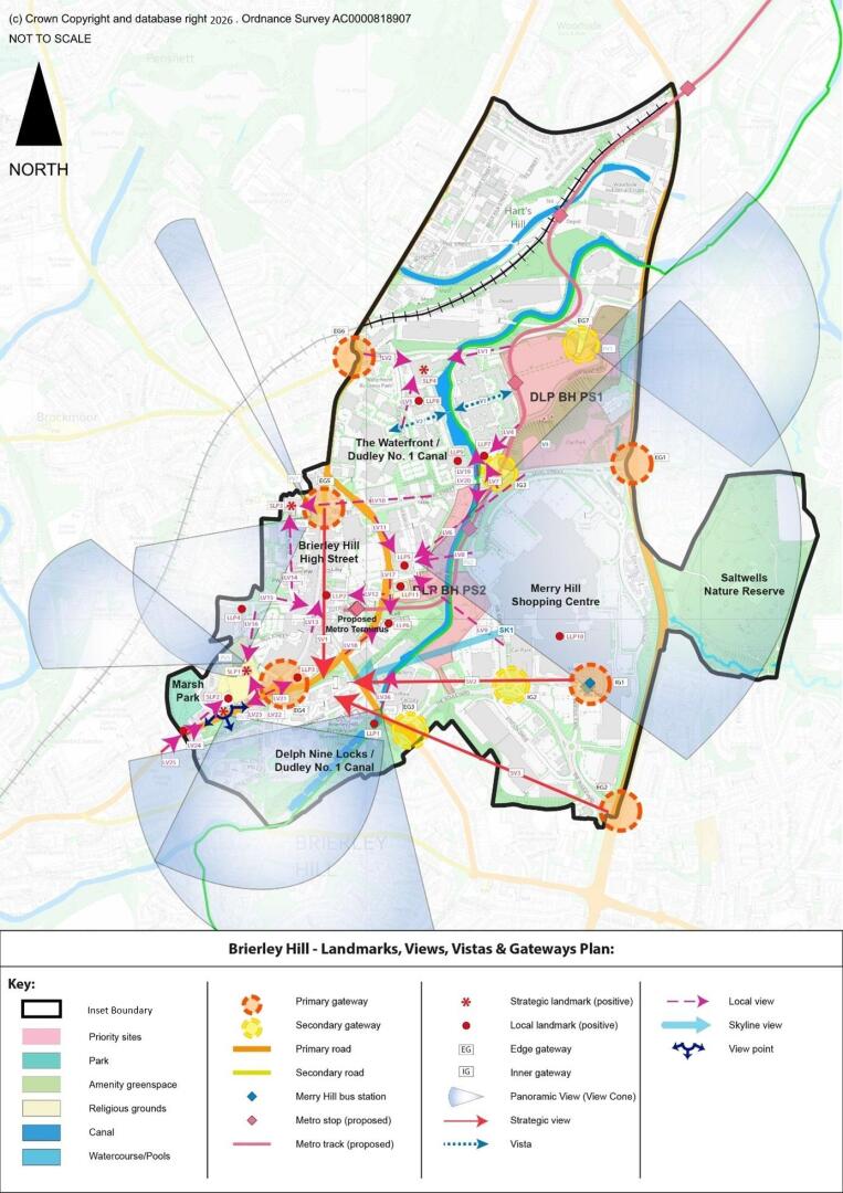
Table 1.1 List of Brierley Hill Landmarks, Views, Vistas and Gateways
|
Strategic Landmark (Positive) |
Heritage asset/designations (where relevant) |
|
|---|---|---|
|
SLP1 |
St Michael’s Church |
Grade II Listed and in a Conservation Area. |
|
SLP2 |
Brierley Hill War Memorial |
Grade II Listed and in a Conservation Area. |
|
SLP3 |
Brierley Hill Civic Hall and Police Station |
Heritage asset in a Conservation Area. |
|
SLP4 |
The Landmark building, Waterfront Way |
In an Archaeological Priority Area (APA) and immediately adjacent to an Area of High Historic Townscape Value (AHHTV). |
|
Local Landmarks (Positive) |
||
|
LLP1 |
Delph Nine Locks/ Dudley No.1 Canal |
Grade II Listed, in a Conservation Area and an APA. |
|
LLP2 |
Brierley Hill Market Hall |
Heritage asset in a Conservation Area. |
|
LLP3 |
St Mary’s Church |
Heritage asset in a Conservation Area. |
|
LLP4 |
Brierley Hill Institute (DY5 3EU) |
Grade II Listed and in a Conservation Area. |
|
LLP5 |
Brierley Hill Health & Social Care Centre |
N/A |
|
LLP6 |
Dudley College Inspired |
Adjacent to an AHHTV. |
|
LLP7 |
Brierley Hop House (public house) |
Adjacent to an AHHTV. |
|
LLP8 |
Former Resonance Music Institute |
In an APA and adjacent to an AHHTV. |
|
LLP9 |
The Copthorne Hotel |
In an APA and adjacent to an AHHTV. |
|
LLP10 |
Merry Hill Shopping Centre |
N/A |
|
LLP11 |
Fat Yue Temple (Fa Yue Buddhist Monastery) |
Heritage asset. |
| Edge Gateway | ||
|
EG1 |
Hurst Lane/ Level Street junction |
Gateway into the Brierley Hill Town centre. |
|
EG2 |
The Boulevard/ Coppice Lane junction |
Gateway into the Brierley Hill Town centre. |
|
EG3 |
The Boulevard/ Mill Street junction |
Gateway into Brierley Hill Town centre. |
|
EG4 |
Church Street/ Venture Way junction |
Gateway to the Conservation Area. |
|
EG5 |
Bank Street/ Level Street junction |
Gateway to the Conservation Area. |
|
EG6 |
John Street/ Dudley Road/ Waterfront Way island |
In the Round Oak APA and Gateway into Brierley Hill Town centre. |
|
EG7 |
Waterfront Way |
Gateway into Brierley Hill Town centre. |
| Inner Gateway | ||
|
IG1 |
Merry Hill bus station |
N/A |
|
IG2 |
The Boulevard/ The Embankment/ Times Square Avenue island |
N/A |
|
IG3 |
Level Street/ Waterfront Way/ Hop House island |
N/A |
| Panoramic View (View Cone) in/out of Brierley Hill | ||
|
PV1 |
From Waterfront Way car park, looking eastwards towards St. Andrews Church, Netherton/horizon. |
Netherton Hill AHHLV, Netherton AHHLV and St. Andrews Church, Grade II Listed. |
|
PV2 |
From the car park at the rear of Brierley Hill Health & Social Care Centre, looking eastwards towards St. Andrews Church, Netherton/horizon. |
Same as above and also Saltwells Nature Reserve, which is also an AHHLV, APA, Geosite and contains a Scheduled Monument. |
|
PV3 |
From Church Hill/Brierley Hill War Memorial, looking south west. |
The memorial is Grade II Listed and in a Conservation Area and the view is towards the Chapel Street estate and Delph Nine Locks Conservation Area. |
|
PV4 |
From Mill Street/canal bridge looking southwards overlooking Dudley No. 1 Canal/Delph Nine Locks |
The Delph Nine Locks contains a series of Grade II Listed locks and is in a Conservation Area and APA. |
|
PV5 |
From the churchyard/St. Michaels looking west towards the Chimney of the former Stevens & Williams Glassworks/ Royal Brierley Crystal, now Woodcock Mews (DY5 3AZ) |
Woodcock Mews is Grade II Listed. |
|
PV6 |
From the green in front of the Brierley Hill Civic Hall looking southwest towards the Chimney of the former Stevens & Williams Glassworks/Royal Brierley Crystal, now Woodcock Mews |
Same as above. |
|
PV7 |
From the green in front of the Brierley Hill Civic Hall looking northwest in the direction of Buckpool, Fens Pools and Barrow Hill Nature Reserve |
Looking out towards Fens Pool AHHLV and Barrow Hill, also an AHHLV, and a Geosite. |
| Skyline Views | ||
|
SK1 |
From The Embankment looking southwest towards the high-rise flats at Brierley Hill |
Across the canal, an AHHTV and APA. |
| Strategic Views | ||
|
SV1 |
From the Level Street/Dudley Road/High Street junction looking south along the High Street towards the high-rise flats at Brierley Hill |
Via canal, Delph Nine Locks Conservation Area. |
|
SV2 |
From Merry Hill Bus Station looking west towards the high-rise flats at Brierley Hill |
Via canal AHHTV. |
|
SV3 |
From The Boulevard looking northwest towards the high-rise flats at Brierley Hill |
Within a Conservation Area. |
| Vistas | ||
|
V1 |
Waterfront east, both directions: east to west and west to east |
The canal is an AHHTV and an APA. |
|
V2 |
Waterfront west, both directions: east to west and west to east |
Within the Round Oak APA and the canal is an AHHTV, and an APA. |
| Local Views | ||
|
LV1 |
From Waterfront Way looking west towards The Landmark building |
Looking towards SLP 4 which is in the Round Oak APA. |
|
LV2 |
From Waterfront Way looking east towards The Landmark building |
Same as above. |
|
LV3 |
From Waterfront West looking north towards The Landmark building |
Same as above. |
|
LV4 |
From Waterfront Way looking southwest towards the Hop House |
To LLP 7. |
|
LV6 |
From Level Street looking southwest towards the Brierley Hill Health & Social Care Centre |
Via the canal, an AHHTV and APA towards LLP 5. |
|
LV7 |
From The Embankment looking northwest towards the Hop House |
To LLP 7. |
|
LV8 |
From The Embankment/Central Way island looking west towards the Brierley Hill Health & Social Care Centre |
Via the canal, an AHHTV and APA towards LLP 5. |
|
LV9 |
From The Embankment looking northwest towards the Brierley Hill Health & Social Care Centre |
Via the canal, an AHHTV and APA towards LLP 5. |
|
LV10 |
From Level Street looking west towards the Brierley Hill Civic Hall & Police Station |
In the Conservation Area looking towards SLP 3. |
|
LV11 |
From Venture Way (as you turn off Level Street) looking southeast towards the Brierley Hill Health & Social Care Centre |
Looking towards LLP 5. |
|
LV12 |
From Cottage Street, junction with Venture Way, looking west towards the rear of Brierley Hill Market Hall |
In the Conservation Area looking towards LLP 2. |
|
LV13 |
From High Street, looking north towards the front of Brierley Hill Market Hall |
In the Conservation Area towards LLP 2. |
|
LV14 |
Along Albion Street, looking north towards the Brierley Hill Civic Hall & Police Station |
In the Conservation Area towards SLP 3. |
|
LV15 |
From the junction of Fenton Street/Moor Street looking eastwards towards five ways junction & the former Marsh & Baxters building at 94 High Street |
In the Conservation Area and APA towards heritage assets. |
|
LV16 |
From Bell Street, looking south towards St. Michael’s Church |
The Church is Grade II Listed (SLP 1) and located within a Conservation Area. |
|
LV17 |
From Venture Way, by the Brierley Hill Health & Social Care Centre, looking southwards towards Dudley College Inspired |
Looking towards LLP 6. |
|
LV18 |
From Venture Way, junction with Mill Street, looking northeast towards Dudley College Inspired |
Looking towards LLP 6. |
|
LV19 |
From Level Street bridge over Dudley No. 1 Canal, looking north towards Hop House/The Waterfront buildings complex |
The canal is an AHHTV and an APA. |
|
LV20 |
From Level Street bridge over Dudley No. 1 Canal, looking south over the canal towards Daniels Wharf & the High Plateau |
The canal is an AHHTV and an APA. |
|
LV21 |
From Church Street, looking northeast towards St Mary’s Church |
The church is a heritage asset and located within a Conservation Area. |
|
LV22 |
From Church Street, looking northwest towards St. Michael’s Church |
The church is Grade II Listed and in a Conservation Area. |
|
LV23 |
From Church Street, looking southwest towards Brierley Hill War Memorial |
The memorial is Grade II Listed (SLP 2) in a Conservation Area. |
|
LV24 |
From Church Street, looking northeast towards Brierley Hill War Memorial |
Same as above. |
|
LV25 |
From Church Street looking northeast to the main entrance gates Marsh Park/ Brierley Hill War Memorial & no. 18 Church Hill |
Same as above and Marsh Park is an APA and in a Conservation Area. |
|
LV26 |
From A4100 road bridge (Nine Locks Bridge) looking northwards, overlooking Dudley No. 1 Canal |
In a Conservation Area and view of the canal, which is an AHHTV and APA. |
Public Realm
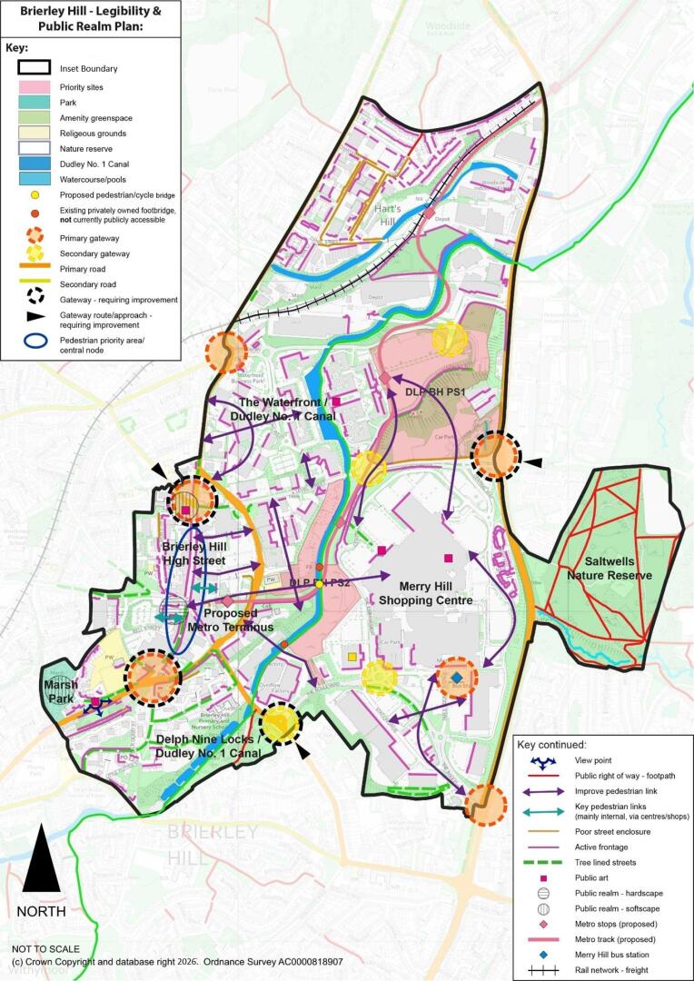
1.16The town’s character is greatly influenced by its public realm, with some locations in need of upgrading. Public open spaces provide a focus for community activity and form connections within the Strategic Centre.
Policy DLPBH2 Public Realm in Brierley Hill
- Primary Public Spaces will:
- give priority to the convenience, enjoyment, and safety of pedestrians
- have active built edges that front the space
- incorporate well-designed street furniture, and hard and soft landscaping
- function as a meeting space; and, as appropriate, be designed to be able to accommodate events
- Pedestrian links will be delivered and existing pedestrian links will be safeguarded and, where necessary, upgraded. All pedestrian links must be designed with pedestrians and, as appropriate, cyclists foremost in mind and respect natural desire lines. Pedestrian links will be required to:
- make a simple and relatively direct connection between the points indicated
- make provision for safe pedestrian movement and crossing including provision for people with restricted mobility
- incorporate pedestrian crossing facilities in all traffic signal controlled junctions where feasible and be designed as attractive, usable and memorable spaces
- be defined by elevations which are appropriately scaled to the width of the link and offer relatively continuous active frontage
- be well overlooked by building frontages to assist natural surveillance
- display a consistent quality of design with street surfaces, lighting, street furniture, signs, hard and soft landscaping. Street clutter must be avoided.
- provide for high quality integrated landscape and biodiversity as an integral part of the design
- offer continuous and twenty-four-hour access to pedestrians.
Justification
1.17‘Public realm’ can be defined as all areas that the public have access to including streets, squares, and open spaces. It is considered necessary to introduce greenery into the towns’ urban environment and resolve the competing needs of vehicles and pedestrians moving through the town centre. The quality of the public realm encountered, along with signage and legibility for visitors to understand and enjoy, is an important part in the role of the strategic centre.
1.18Key design principles for the public realm include:
- Quality of the Public Realm: increase the adaptability of spaces for future use; create legible spaces and routes that add to the ‘sense of place’ of an area; relate public spaces to surrounding buildings and vice-versa; introduce diversity; and improve continuity and enclosure.
- Active Frontages: a common building line creates continuity of frontage and provides definition and enclosure to the public realm. Minimising set back distances increases the ability of a building to interact with the public realm. In areas such as Brierley Hill High Street, buildings should be built adjacent to the pavement.
1.19Passive, active, and incidental open spaces play a significant role in urban design. These different types of open spaces within Brierley Hill are crucial for creating liveable and vibrant communities. Passive spaces offer moments of tranquillity and respite, active spaces promote physical well-being and social interaction, and incidental spaces provide opportunities for leisure and engagement. Improving pedestrian links in Brierley Hill should take account of safety, accessibility, aesthetics, and the overall urban experience.
1.20Within the town centre, the High Street forms a key central focus and major area of public realm which has been delivered through the High Street Heritage Action Zone and Future High Street project. New paving, street trees, and new street furniture have been installed, a new ‘Link space’ has been created between the High Street and Little Cottage Street as well as major enhancements undertaken to the Brierley Hill War Memorial and the Civic Hall Green. There are further opportunities for public realm improvements for the area, for example, to the area identified for the future Midland Metro terminus Also of particular significance is the opportunity for improved east to west pedestrian connections across the centre, linking Brierley Hill High Street with Asda, the canal, Merry Hill Centre and Saltwells.
1.21Where appropriate, street trees will be required along public thoroughfares, within public spaces and in new developments. This will include new public streets or spaces created within developments or where a development fronts or joins a public thoroughfare and public space. In such circumstances the incorporation of street trees must be considered at the design stage of the development to ensure there is adequate rooting area to avoid future nuisance and that street trees are co-ordinated with the overall streetscape. Street tree planting should take into account overhanging branches, traffic safety, underground and overhead services.
Figure 1.2: Brierley Hill Legibility and Public Realm Plan
Green Infrastructure
Policy DLPBH3 Green Infrastructure in Brierley Hill
- The following areas will be a focus for new tree planting as well as other green infrastructure enhancements, which shall also include nature recovery measures in appropriate locations and in accordance with the provisions of Policies DLP31 to DLP34.
- Within the designated Wildlife Corridors – Wildlife Corridors shall be no less than 10m wide, unless, through an assessment of a development proposal, this is evidenced as impractical to achieve and compensatory nature conservation enhancement measures are provided elsewhere within the inset plan area.
- Within designated Sites of Local Importance for Nature Conservation (SLINCs).
- Within Primary Public Spaces and along Key Pedestrian Links.
- Alongside Pedmore Road, including the formation of a new entrance to Saltwells National Nature Reserve (NNR) and a footpath link within Saltwells Wood, on the eastern side of the carriageway.
- Within a green corridor between the proposed Midland Metro Stop at Canal Street and Fens Pool Local Nature Reserve (LNR)/Special Area of Conservation (SAC).
- Within Brierley Hill High Street, with a focus on additional tree planting.
Justification
1.22Brierley Hill and its surrounds contain a rich diversity of wildlife, much of which is directly attributed to its industrial past. The Dudley Canal works its way through the area in a general north to south direction providing a valuable ecological/recreation corridor. The remnants of the no longer navigable Pensnett Branch Canal form an undisturbed waterbody with heavily wooded margins. Just outside the inset plan boundary, rich veins of underlying natural resources such as coal, fireclays and ironstones were heavily mined at Saltwells National Nature Reserve (NNR) and Buckpool and Fens Pool Local Nature Reserve (LNR), both of which have, over time, been reclaimed by wildlife. Saltwells NNR forms part of the Black Country Global Geopark as a Geosite with three Sites of Special Scientific Interest, two of them being geological. The site is heavily wooded and is species rich with locally rare fauna and flora. These wildlife rich sites and the avenues for movement of species between them need to be protected and enhanced within the wider landscape context of all new development to combat the combined challenges of climate change and past habitat fragmentation.
Tree planting
1.23While the Strategic Centre is heavily urbanised, there is a 17.2 % canopy cover within the Brierley Hill Ward[1]. This figure is slightly above that of 16% canopy coverage for urban areas within the UK, however, falls below the average for the borough of 18.2%.
1.24The benefits of having more trees include combatting potential future problems with flooding, air pollution and reducing the heat island effect. It is considered that every new development should incorporate trees and, where appropriate, include the creation of hedgerows (for boundary treatment), woodland, meadows and ponds, including natural Sustainable Drainage Systems. These measures can play a significant part in reducing the impact of climate change and reducing air pollution, as well as providing an uplift in biodiversity and creating valuable habitats. If a site is located within an important strategic location, such as adjacent to a wildlife corridor, wildlife friendly landscaping (including green roofs) should form a significant important element of the scheme.
1.25The lack of green spaces and parks in the centre has been identified as an issue. A target number of new trees to be planted within the Inset Plan boundary during the plan period is considered an effective way of making a significant contribution towards the greening of Brierley Hill. However, it is recognised that new tree planting would need to be carried out in a structured and planned way so as for instance to create wildlife corridors and other open space networks as well as greening footpaths, cycleways and roads (as boulevards).
Wildlife Corridors
1.26To ensure that essential connections are made between key green spaces it is necessary to identify the wildlife network. This will create a vibrant network of local wildlife sites, linked by corridors which enable wildlife to thrive and move freely through the area and out into the wider environment. Wildlife Corridors have been identified on the Brierley Hill Strategic Centre Inset Policies Map.
1.27The Wildlife Corridor network provides a series of pathways, some of which exist and others which will require creation habitat creation (such as along areas of the Pedmore Road and Harts Hill). They are designated to provide efficient routes which would allow species to move between Fens Pool and Saltwells. This strategic network will provide the focus for biodiversity enhancements, including through Biodiversity Net Gain measures and through the Local Nature Recovery Network where appropriate.
1.28The specifications for each section of the Wildlife Corridors would be based on its position in the network and the habitats required for the relevant species. The routes have been designated to accommodate the requirements of both aquatic and terrestrial species.
1.29The corridors are required to be a minimum of 10 metres in width combined with wider bays of suitable habitat and other larger wildlife sites at frequent intervals to provide space for suitable landscaping design and habitat for the area's key species. Canal based corridors, due to their character, will need to be wider than 10 metres. Breaks along the corridor must be minimised and connectivity increased if they are to function effectively. Existing roads will create significant obstacles to certain species, such as Great Crested Newts, and actions to reduce these barrier effects should be carried out over time and measures put in place that may aid their movement such as Newt grids.
Saltwells Nature Reserve
1.30Brierley Hill has a lack of green open space, yet nearby Saltwells Nature Reserve, designated as both a National and Local Nature Reserve is one of the UK’s largest urban nature reserves, covering 100 Ha (247 acres). The nearest part of Saltwells Nature Reserve to the Merry Hill Centre has been incorporated within the Inset Plan boundary.
1.31Currently the heavily trafficked Pedmore Road (A4036) restricts the movement of pedestrians between the Merry Hill Centre and Saltwells Wood. Despite having a long frontage to Pedmore Road, the pedestrian access into Saltwells Wood goes largely unnoticed. To give the site more of a presence along Pedmore Road, it is proposed that a prominent entrance feature is created, and a clearer route created to encourage pedestrian movement between the nature reserve and the Merry Hill Centre. This will enable the nature reserve to be the main area of open space within the Strategic Centre, as a unique central park with significant nature conservation and heritage assets.
1.32Associated with this feature, there is scope to enhance the pedestrian crossing across Pedmore Road as well as providing a landscaped area on the western side of this route. The potential to realign and accommodate the footway on the eastern side of the carriageway through to the Saltwells Wood would be welcomed, to increase pedestrian movement and accessibility.
Fens Pool Nature Reserve and Special Area of Conservation (SAC)
1.33Fens Pool Nature Reserve is located to the north-west of the inset plan boundary, opportunities exist to enhance the connection between the two nationally/internationally recognised nature conservations sites of Fens Pool and Saltwells Nature Reserve, through the creation of green infrastructure improvements and wildlife corridors.
Brierley Hill High Street
1.34Dudley has been successful in securing funds via the High Streets Heritage Action Zones (HAZ) scheme, which aims to find ways to champion and revive our historic high streets. Administered by Historic England and partnered with Dudley Council, projects are particularly centred on improvements to the historic urban fabric located within the Brierley Hill High Street Conservation Area.
1.35The High Street itself is relatively lacking in vegetation and as such it has a rather harsh urban appearance. Opportunities exist therefore to build upon the regeneration potential of the High Street HAZ by making improvements to the public realm here.
1.36Traffic along the High Street is two-way with laybys for parking on the western side. Opportunities should be explored to adjust parking bays in order to provide opportunities for tree planting, to help create an attractive avenue of trees along the High Street. This would also be beneficial for air quality locally and for carbon capture. An attractive High Street has the potential to encourage more shoppers, and therefore increase the vitality of this part of the centre.
Historic Environment
1.37The historic environment and heritage assets of Brierley Hill will be, conserved and enhanced as per Policies DLP54-DLP58. This section sets out the key characteristics of the Brierley Hill Inset Plan area and town centre specific evidence base information for context, but no additional policy provisions to Policies DLP54-DLP58 are set out (other than in site specific allocations).
1.38The historic importance of Brierley Hill is recognised as a major asset in delivering regeneration and enhancing the town centre as more attractive, engaging and vibrant place for people to live, work and spend time. The name Brierley Hill derives from the Old English word ‘brer’, meaning the place where the Briar Rose grew; ‘leah’, meaning a woodland clearing; and ‘hill’. Originally established as a settlement in the woodland of Pensnett Chase, it began expanding rapidly following the Chase’s enclosure in 1784 and the construction of the canal in 1776-9.
1.39At the beginning of the 19th century the area had become heavily industrialised with a number of quarries, collieries, brick, glass, and iron works emerging. Major employers in the town in the 19th century included: the Round Oak Ironworks and later Steelworks, founded in the 1850s; Royal Brierley Crystal, one of the oldest and most prestigious names in British Glassware; Harris and Pearson brick makers; and Marsh and Baxter’s, famous for curing ham and bacon and being major producers of sausages and pork pies, and more recently known about thanks to the Black Country Living Museum ‘Forging Ahead’ programme.
1.40Located within the centre of Brierley Hill is the Brierley Hill High Street Conservation Area and located just to the south is the Delph Nine Locks Conservation Area. There are a number of statutory Listed Buildings, such as the Grade II Listed St Michaels Church, Brierley Hill War Memorial, Brierley Hill former Technical Institute and Library, the former Royal Brierley Crystal Glassworks and the scheduled remains in Saltwells. There are also various non-designated heritage assets such as the Marsh Park Archaeological Priority Area (APA), the Adelaide Street Triangle Area of High Historic Townscape Value (AHHTV), Saltwells Area of High Historic Landscape Value (AHHLV) and Geosite, as well as individually significant buildings and structures such as the Locally Listed St Mary’s Catholic Church, Brierley Hill Market, and Brierley Hill Civic Hall.
1.41The ‘Brierley Hill Urban Historic Landscape Characterisation’ (UHLC) provides the evidence base to inform an understanding of the town's historic character. New developments in Brierley Hill should be designed to reinforce and enhance local distinctiveness, and full reference should be made in Design and Access Statements accompanying planning applications to the Brierley Hill UHLC.
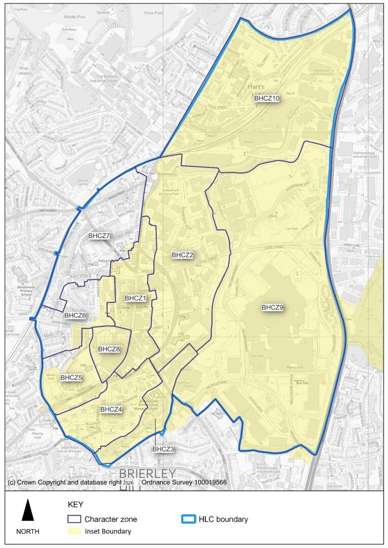
1.42The boundary of the UHLC study area is not contiguous with that for the Inset Plan but spreads wider in order to more fully capture the historic extent of Brierley Hill and to include its associated hinterland. The study describes the historical development of Brierley Hill and identifies ten Historic Townscape Character Zones within the Town Centre and beyond. Each character zone was individually assessed and provided a summary description of its townscape, architectural and historic character and archaeological potential. These are:
- The High Street (BHCZ1)
- Area of modern and late 20th century industrial and commercial development (BHCZ2)
- The Delph and historic canal side (BHCZ3)
- Mid-20th century high-rise development (BHCZ4)
- St Michael’s Church, Marsh Park and mixed housing development (BHCZ5)
- Mid-20th century low-rise middle class housing development (BHCZ6)
- Late 19th and early 20th century terraced housing development (BHCZ7)
- Modern town centre shopping and recreation development (BHCZ8)
- Merry Hill Shopping Centre (BHCZ9)
- Harts Hill (BHCZ10).
Figure 1.3: Brierley Hill UHLC Boundary and Character Zones
1.43The Brierley Hill High Street Conservation Area was designated on the 12th March 2009, due to it forming a significant part of the mid-18th to early 19th century development of the borough and due to the group value of surviving historic buildings. The conservation area is focused along the High Street, with the extent of the conservation area being determined by the extent of the historic town centre and the survival of historically significant buildings and spaces.
1.44In 2009 a Conservation Area Character Appraisal and Management Plan was published for Brierley Hill setting out the various features which give the Brierley Hill High Street Conservation Area its special architectural and historic interest. The appraisal identifies six separate character areas within the Conservation Area, these being: the Civic Centre, The High Street, St Michael’s Church and the surrounding main street frontages; Marsh Park and Seager’s Lane; Albion Street and Talbot Street; and Bell Street. Despite these areas having individual characters, together they provide the Brierley Hill High Street Conservation Area its significance. The appraisal also identifies a number of issues that negatively impact on the Conservation area and explains why it has been identified by Historic England to be a ‘Conservation Area at Risk”.
1.45In 2019 the High Street Heritage Action Zone Programme (HSHAZ) was established. It is a nationwide initiative funded by the Government and run by Historic England designed to secure lasting improvements to historic high streets. In 2019 Brierley Hill High Street was selected as one of 68 High Streets across England to receive a share of the fund following the submission of a successful bid by the Council. A significant part of the evidence which helped to underpin the bid and the programme of projects contained within it, related to the key issues affecting the Brierley Hill High Street Conservation Area as well as the CACA designations.
1.46The Delph ‘Nine’ Locks Conservation Area was designated in February 1976 and then updated again in April 2007. The canal Conservation Area marks the beginning of the Dudley Canal and the navigation link between the West Midlands and the West of England. It was built as a flight of nine locks on the Dudley No.1 Canal by Thomas Dadford Senior between 1776-79. The canal-side buildings include the Grade II listed Delph stables, which were built between 1900-1914 to house up to 14 horses. The Conservation Area forms part of the Brierley Hill UHLC study, identified as Character Zone 3: The Delph and historic canal side. In 2007 a Conservation Area Character Appraisal and Management Plan was prepared for the Delph ‘Nine’ Locks Conservation Area.
1.47Planning applications with the Conservation Area will be determined with particular reference to the relevant Conservation Character Appraisal, Management Plan and Historic Landscape Characterisation.
Sustainable Transport and Active Travel
1.48Local Plan Policies DLP67-DLP74 provide the strategic transport policies for the Borough. This section sets out key priorities for Brierley Hill Strategic Centre.
Policy DLPBH4 Sustainable Transport and Active Travel in Brierley Hill Strategic Centre
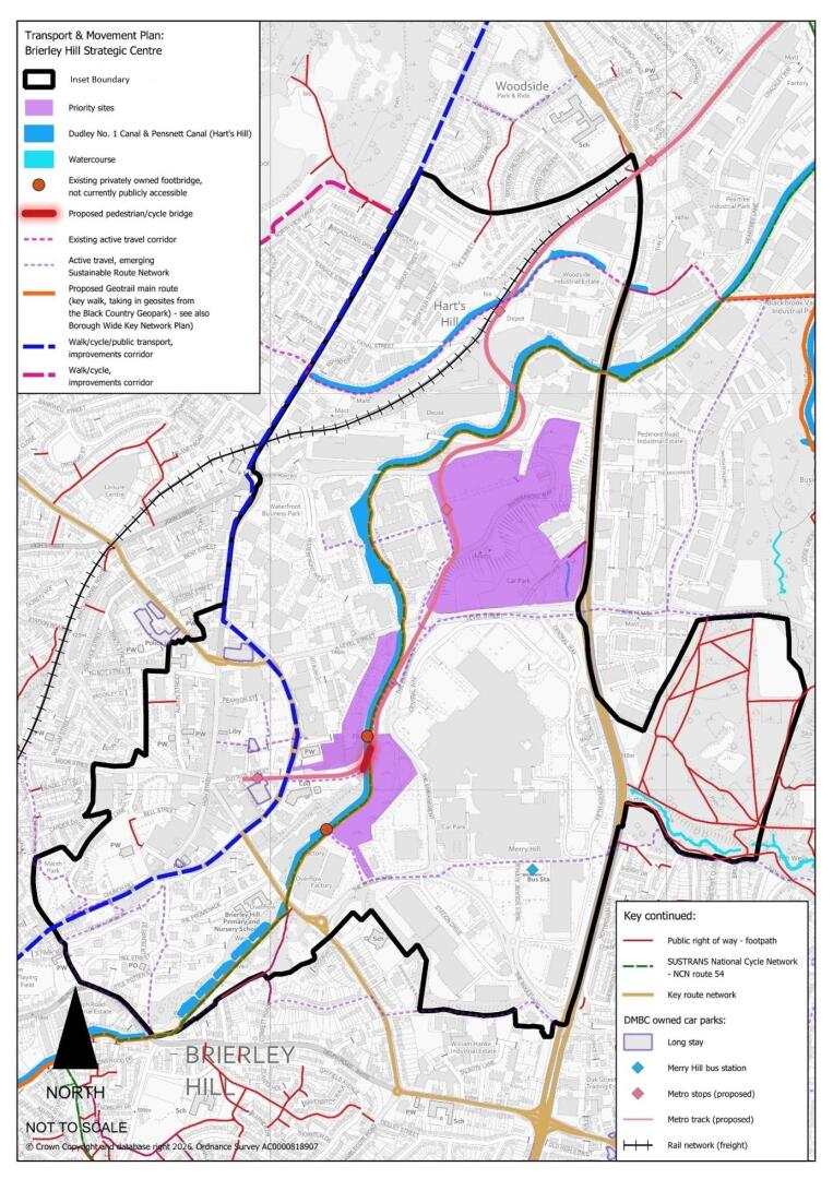
- Key schemes and priorities for sustainable transport improvements within Brierley Hill Strategic Centre are identified on the Inset Policies Map and Plan DLP BH4. Development proposals within the centre should ensure alignment with these schemes and provide connections to them to ensure opportunities for sustainable and active travel are maximised. Key schemes and priorities within the Inset Plan area are:
- Metro route stops and terminus and associated active travel improvements (including additional cycleways as detailed below).
- New cycleway links including along the A461 Corridor linking towards Stourbridge and Dudley with connections to Moor Street, Mill Street and Level Street catchment areas.
- New cycleway links along the A4036 Corridor linking Brierley Hill town centre to surrounding residential and employment catchment areas.
- Improvement and connectivity to SUSTRANS National Cycle Network (NCN) 54 and Dudley No. 1 Canal.
- The Geotrail Walking Route follows the Dudley No. 1 Canal (north) towards Dudley via hop on/hop off metro links or from the canal (southeast) across to Quarry Bank Park and Quarry Bank Local Shopping Centre, and southwest to the Withymoor Playing Fields.
- Improved connectivity to the Wednesbury-Brierley Hill Metro Corridor and associated metro stops.
- Internal town centre connectivity linking Brierley Hill High Street area to Merry Hill Shopping Centre and The Waterfront.
- Improved links to and within Saltwells National Nature Reserve and to Buckpool, Fens Pools and Barrow Hill Local Nature Reserve, also onward connections to Smestow Valley (northwest) and Netherton Park/Bumble Hole Local Nature Reserve (east).
- Regard should be had to active travel links beyond the Inset Plan area, including proposed cycle routes along the A461 (linking Stourbridge and Dudley town centres).
- Proposals for commercial and business development that involve more than 500sqm (gross) of floorspace with the Merry Hill Centre Core Area or within well-linked edge-of-centre locations to that core area, shall evidence the means to which they are compatible with the objectives of achieving sustainable development. This evidence must incorporate the setting out of provisions for the enablement or enhancement of sustainable means of travel and integrated modes of transport to and within individual strategic centres, with a particular focus on the management of demand for car parking and car-borne traffic, including through car parking regimes.
Justification
1.49Brierley Hill is the Strategic Centre in the borough providing a range of housing leisure, tourism, and employment opportunities, but further growth requires improvements to public transport, cycling, and walking networks whilst facilitating opportunities for emerging innovations i.e., micro mobility, such as bicycles, e-bikes, and electric scooters.
1.50Currently bus provision in Brierley Hill town centre is managed as follows:
- On road stops serving Brierley Hill High Street
- Merry Hill Bus Station serving the shopping centre
- On road stops serving The Waterfront complex
1.51The High Street stops and shelters have been improved as part of the Brierley Hill Future High Street public realm improvements and provide good direct access to the High Street retail core. However, the public transport/bus offer linking the three areas within the centre (mentioned above) requires improved bus service co-ordination. This will improve the customer experience, improve operational efficiency, and provide high quality bus access into and within Brierley Hill.
1.52Given that Brierley Hill Town Centre has no direct access to the national rail network (with Cradley and Stourbridge Stations currently the closest options), the forthcoming Metro will have a key role in enhancing the accessibility for people travelling to and from Brierley Hill Town Centre. In Dudley Borough, the proposed Metro line provides a link from Castle Hill in Dudley Town Centre and then continues west towards Brierley Hill. The Metro will also provide the borough with a connection to the national rail network at Dudley Port.
1.53There is a need to continue to safeguard the route, proposed metro stops including the terminus at Cottage Street, Brierley Hill as it remains under development and to enable future development sites within the town centre to reflect and complement the new Metro line (supporting economic regeneration and growth).
1.54Effective management of the Key Route Network (KRN) and its links to the Strategic Road Network (SRN) are integral in supporting increased investment and regeneration in and around Brierley Hill Town Centre. Maintaining and improving the efficiency of the local road network will benefit commuters, visitors and public transport users by reducing congestion and providing more reliable journey times into and out of Brierley Hill. Major Network Scheme improvements, including those to the A461 corridor, are part of this management.
1.55A 20mph speed limit covering the retail core of the High Street area of Brierley Hill has been implemented as part of the Brierley Hill Future High Street Fund public realm works. Potential expansion of this reduced speed limit would align with national policy which places vulnerable road users at the top of the hierarchy by providing safer and enhanced environments for pedestrians and cyclists. Furthermore, complementary traffic management measures, including improved pedestrian crossing facilities along primary thoroughfares, would be incorporated into this 20mph zone scheme.
1.56Brierley Hill Centre sits alongside the Sustrans National Cycle Network (NCN) Route 54 (Derby to Stourport), which links to Dudley to the northeast and Stourbridge to the southwest. Improved connectivity to NCN Route 54 is crucial to maximise active travel opportunities. Improved connectivity between Brierley Hill High Street and Merry Hill Shopping Centre supports the west-east link and also reinforces the NCN 54 link via the Daniels Wharf Priority Site. The proposed metro terminus and associated works provides opportunities for links to the Daniels Wharf Priority Site.
1.57Essentially a ‘hub and spoke’ ethos will be developed in Brierley Hill Centre where placemaking efforts will be supported by a network of sustainable transport links to the KRN, SRN and the National Rail Network, whilst also promoting accessibility to other local centres to raise Brierley Hill’s offer to its businesses, residents and visitors.
1.58A number of sites have been identified within the Brierley Hill Strategic Centre which are appropriate for residential developments. Residential living within centres can increase the vitality of an area and provide natural surveillance outside of normal business hours. Providing in-centre living within Brierley Hill Strategic Centre can increase the viability of the centre and provides a sustainable location due to public transport connections and increased opportunities for walking and cycling.
Policy DLPBH5 Residential Growth in Brierley Hill
- Sufficient land will be provided to deliver up to 1,438 new dwellings within the Brierley Hill Inset Plan area during the plan period up to 2041.
- Residential development shall be the main appropriate use on the following Housing Sites, as identified as residential development allocations on the Brierley Hill Inset Plan Policies Map, with other uses being unacceptable, unless they are small in scale and necessary to support residential-led development or support existing business operations on employment sites, in accordance with DLP18:
- Land at Waterfront Way and Level Street (Priority Site)
- The Embankment / Daniels Land (Priority Site)
- Level Street/Old Bush Street
- Waterfront Way West
- Canal Walk South, Mill Street
- Land at Moor Street
- Land at Bell Street and High Street
- Oak Court Car Park, Dudley Road
- Old Carriage Works, Mill Street
- Proposed residential development within the Inset Plan area shall offer a range of house types and tenures, in accordance with the provisions of Policies DLP10, DLP11, DLP12 and DLP28 of this plan.
- Proposed residential development on the Housing Sites shall accord with the detailed provisions, development and design parameters for each Housing Site.
- Residential development across the Inset Plan area will be required to contribute to infrastructure provision in line with Policy DLP6, to be assessed on a site-by-site basis dependent upon the latest analysis at the time.
Justification
1.59As Brierley Hill is the Strategic Centre within Dudley and contains existing and proposed improved public transport stops, under the overarching aim of making the efficient use of brownfield land for sustainable housing development, Brierley Hill is expected to have a strong role in providing new housing within the Strategic Centre.
1.60On this basis, and as evidenced in the Dudley Urban Capacity Report, it is appropriate to set a target figure of 1,438 new houses to be delivered by 2041.
1.61New housing sites have been identified within the Inset Plan area to meet this need for housing growth, particularly on sites which are sustainably located such as those sites located close to the Midland Metro line and its stops. New housing development within walking distance of the Metro stops or bus routes serving the stops, would create highly sustainable forms of development.
1.62In order to create sustainable communities, there is a recognised need to develop high quality housing that meets a range of needs, such as family housing, housing for single person households, the elderly and those unable to compete on the open market.
1.63A flexible and creative approach will be needed to provide a mix of dwelling types and tenures at a variety of densities suitable to a Strategic Centre, which is required to accommodate a balanced population. Residential development will be assessed and delivered in accordance with the provision of Policy DLP28 of this plan and will have an appropriate density dependent on the individual site.
Employment and Offices in Brierley Hill
1.64Four broad areas have been identified to support the continued office and employment uses within Brierley Hill Centre through consolidating these uses into the following four areas and setting appropriate uses for them:
- Woodside Local Employment Area
- Waterfront West Office Park
- Waterfront West Business Park
- Waterfront East
Policy DLPBH6 Office and Employment Uses in Brierley Hill
- Proposed development within the following Office and Employment Areas, as designated on the Brierley Hill Inset Plan Policies Map, shall be in accordance with the uses set out within this policy as being appropriate to a particular area. Proposed development for a use which is not acceptable to a particular designated area will be rejected unless it can be successfully evidenced as being subsidiary to, and, in support of an acceptable use.
- Woodside Local Employment Area – appropriate uses: those uses set out within Policy DLP19 of this plan, as being appropriate to Local Employment Areas
- Waterfront West Office Park – acceptable uses E(g) (i) (Offices); F1(a) (Education)
- Waterfront West Business Park – appropriate uses: E(g) (Offices, Research and Development facilities and light industrial development); B8 (Storage and Distribution); F1(a) (Education)
- Waterfront East Office Park – acceptable uses at first floor and above E(g) (i) (Offices)
Justification
1.65Enterprise Zone status was granted to Dudley MBC for the DY5 Business and Innovation Enterprise Zone (DY5 EZ) in April 2017 for a period of 25 years (until March 2042). The DY5 Enterprise Zone comprises six main areas. Those areas within the plan area comprise:
- The Waterfront (8.03 Ha) - Existing development of Grade B office space.
- Archill (17.17 Ha) - undeveloped land comprising current use of surface car parking with some areas currently vacant and not presently in use.
- Harts Hill (14.79 Ha) - an area dominated by mixed quality industrial buildings in multiple ownerships.
- Canal Walk (7.02 Ha) - Land beside the canal overlooking the Merry Hill Centre.
1.66The benefits for a company locating within DY5 EZ include up to £55,000 per year business rate discount over a five-year period. Broad uses were allocated for each of the specified areas within the EZ.
1.67These uses were reviewed within the DY5 EZ Review particularly focusing on their market attractiveness. In summary, they evidenced that for:
- Offices - nationally there is a trend of occupiers wanting to locate in regional Central Business Districts, moving away from out of town and sub-regional centres. Businesses are gravitating to the large skills markets, hence the current trend towards regional CBD’s such as Birmingham and that Dudley as a sub region having delivered no new office space within the last 12 months, with an overall vacancy rate of 4.5%.
- Industrial – there is demand for sites and premises for large logistics companies, dominated by the fast-growing e-commerce sector. These urban logistics centres need easily accessible by the local road network, close to the population they need to serve and in locations where their 24-hour operations do not cause a nuisance to neighbours.
1.68However, with regard to offices, the Centres Study identified The Waterfront as remaining a viable office destination, particularly given the benefits associated with that area’s inclusion within DY5 EZ.
1.69Evidence on market attractiveness, coupled with a lack of recorded new development for offices and industrial uses within Brierley Hill, has led to the some uses being reallocated for alternative uses, including residential. As such, a large housing windfall allowance at the Waterfront has been included in the housing land supply. This will support the need to meet housing growth targets and locate new residential development in sustainable locations.
1.70Therefore Harts Hill, Land at Waterfront Way and Level Street, and Canal Walk South have been allocated for residential use. However, it is considered that the potential loss of these industrial and office designations within the plan area will be counterbalanced by the following proposed broad locations for primarily the consolidation of the existing office and industrial employment uses:
- Woodside Local Employment Area
- Waterfront West Office Park
- Waterfront West Business Park
- Waterfront East
Brierley Hill Inset Site Allocations
1.71Brierley Hill Inset Plan area contains two of the Borough’s ‘Priority Sites’ at The Embankment / Daniels Land and Land at Waterfront Way and Level Street. Three ‘Opportunity Sites’ have been identified where redevelopment and regeneration would provide benefits to the centre. The allocated sites do not preclude or diminish the importance of investment or change elsewhere within the centre, they simply reflect the Council’s wish to prioritise and progress projects which will have a significant impact and act as a catalyst for wider change.
1.72In addition, there are several sites identified for residential development within the Inset Plan area. These are identified within Local Plan Policy DLP10 as part of the overall housing land supply as summarised below.
1.73A policy is provided for each Priority and Opportunity site which identifies acceptable uses. For the Priority sites, key design principles are included within the policy, and these are based on an assessment of land use, access and movement, layout and form, scale and mass, character and appearance, and landscape and public realm.
|
Site |
Mixed Use |
Minimum Residential Capacity |
|---|---|---|
|
Priority Sites |
||
|
Land at Waterfront Way and Level Street (DLP BH PS1) |
No |
500 dwellings |
|
The Embankment / Daniels Land (DLP BH PS2) |
No |
300 dwellings |
|
Opportunity Sites |
||
|
Brierley Hill Civic Core Zone (BH OS1) |
Yes |
N/A |
|
The Waterfront East Entertainment Zone (BH OS2) |
Yes |
N/A |
|
The Venture Way Health and Education Zone (BH OS3) |
Yes |
N/A |
|
Housing Sites |
||
|
Land at Moor Street (DLP BH H001) |
No |
60 dwellings |
|
Waterfront Way West (DLP BH H002) |
No |
61 dwellings |
|
Canal Walk South, Mill Street (DLP BH H003) |
No |
250 dwellings |
|
Level Street/Old Bush Street (DLP BH H004) |
No |
95 dwellings |
|
Oak Court Car Park, Dudley Road (DLP BH H005) |
No |
24 dwellings |
|
Old Carriage Works, Mill Street (DLP BH H006) |
No |
28 dwellings |
|
Land at Bell Street and High Street (DLP BH H007) |
No |
120 dwellings |
Policy DLPBHPS1 (Priority Site) Land at Waterfront Way and Level Street
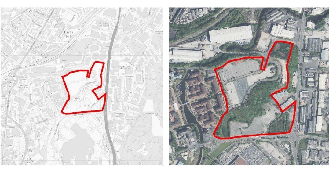
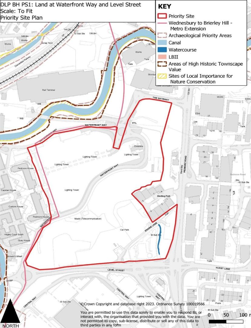
- This site will be allocated for residential redevelopment. The site should deliver a minimum of 500 dwellings.
- Delivery phasing of dwellings:
- Residential development, in accordance with Policy DLP28. Indicative capacity of a minimum of 500 dwellings, but this is not a cap and capacity could vary depending on type and mix of housing provided.
- Proposals to take account of and complement the Metro route, stations and associated public realm provision.
- 2025/2026 - 2028/2029 - 60 dwellings
- 2029/30 - 2033/34 - 210 dwellings
- 2034/35 - 2038/39 - 230 dwellings
- This policy sets out the spatial framework and specific policy requirements – other standard policy requirements will also apply set out in the DLP.
- The site is in private ownership.
- Impact on infrastructure provision:
- School place impacts
- Analysis suggests that education infrastructure needs arising from the DLP growth are likely to be accommodated via expansions to the current school estate as opposed to the creation of new school(s). However, due to the DLP plan period extending beyond current education forecasts this analysis would be ongoing, and contributions may be required.
- Health
- Analysis suggests that additional GP consulting rooms may be required as a result of residential growth in Brierley Hill, therefore contributions may be required to support this service provision on a site by site basis.
- Highways impacts
- The site is highly accessible and has direct access to numerous alternatives to private car use, any proposals must provide high quality access to active modes of travel. Vehicular access is available off Waterfront Way and Level St. The number of access points required, and their design should be subject to further detailed transport assessment (that has been scoped and developed in consultation with the Council) and is dependent upon the nature of any proposed development scheme. Regard should be had to the impact of the Metro Route and its associated Station at the Waterfront, including any remodelling of the road layout on or around the site to facilitate the delivery of the Metro and safeguard the route for future extension. A key part of the site layout should be connections to the cycling and walking network within and around the strategic centre.
- Biodiversity Net Gain
- There are no designated nature conservation assets on this site. Policy DLP31 and DLP32 will apply.
- Open space requirements
- It will be necessary for the site to provide areas of open space that connect the development to the surrounding areas and connect to good-quality walking and cycling routes that provide access to the nearby Canal network. The needs of the development for playing pitches and built sports facilities will need to be met in line with policies DLP6 (Infrastructure Provision) and DLP38 (Playing Fields and Sports Facilities).
- Drainage
- Sustainable drainage systems that are sufficient to achieve greenfield runoff rates should be provided for the site, in accordance with Policy DLP43 and be approved by the LLFA.
- Other considerations
- Due to the site’s elevated location views into and out of the site should be considered as well as how the site responds to its wider surroundings and key views, including Panoramic Views 1 (PV1) and 2 (PV2) towards Netherton’s Historic Church, St Andrews, and Vista 3 (V3) and Local Views 1 (LV1) and 4 (LV4).
- Historic Environment
- The site is currently a large surface carpark created for the Waterfront Development c.1997. It is located in Major Character Zone Pensnett Chase and within Brierley Hill Character Zone 9 ‘Merryhill Shopping Centre’. Located to the north and west of this opportunity site is the Dudley No.1 Canal which is an Area of High Historic Townscape Value (AHHTV) and Archaeological Priority Area (APA) consideration therefore needs to be given to any potential impacts on their setting and significance. The land in the north of this site is higher than that in the south. The two areas were exploited differently in the past. The lower lying land (in and around Engine Lane) was occupied by collieries (there are two recorded mine shafts in this area) whilst on the higher ground stood the Level New Furnaces (HER 7837). For further information refer to the Brierley Hill HLC.
- Design principles
- New development at this location will represent higher density development (likely to be a minimum of 95dph but parts of the site would be appropriate for even higher density development). New development should be perimeter blocks that clearly define public and private spaces. Any parking provided should be in the courtyard within the perimeter blocks or upper floors of multi-storey car park. All development should create active ground floor frontages facing any public ream and proposed Metro infrastructure. All new development should create a network of streets and spaces in line with the planning policies on Public Thoroughfares and Primary Public Spaces. Existing trees, ecology and watercourses should be protected and enhanced and incorporated into the proposed site layout. Building height will be assessed during detail design or planning application stages. Developments should ensure that the layout and design is informed by a Landscape and Visual Impact Assessment (LVIA) / Landscape Visual Appraisal (LVA)
- School place impacts
- To ensure permeability, the layout should connect to the surrounding roads, pedestrian routes, and metro station. Additionally, the layout must also incorporate areas reserved for Midlands Metro Alliance (MMA) and the metro station.
Policy DLPBHPS2 (Priority Site) The Embankment / Daniels Land
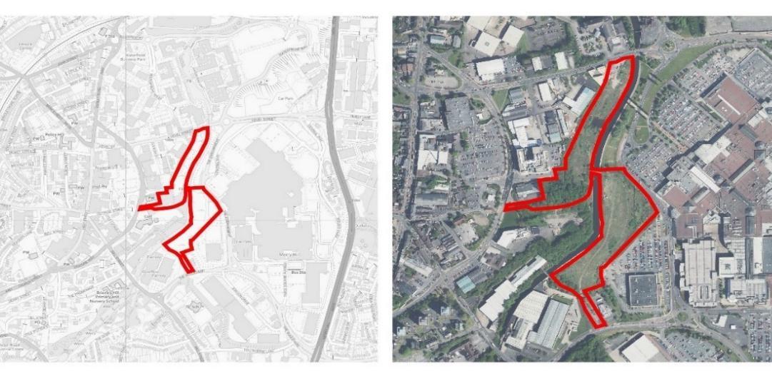
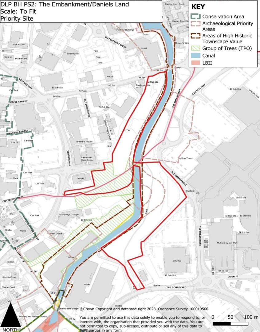
- This site will be allocated for residential redevelopment. The site should deliver a minimum of 300 dwellings.
- Delivery phasing of dwellings:
- Residential development, in accordance with Policy DLP22. Indicative capacity of a minimum of 300 dwellings, this is not a cap and capacity could vary depending on type and mix of housing provided.
- Proposals should take account of and complement the Metro route, stations and associated public realm provision.
- 2025/2026-2028/2029 - 60 dwellings
- 2029/30-2033/34 - 160 dwellings
- 2034/35–2038/39 - 80dwellings
- This policy sets out the spatial framework and specific policy requirements – other standard policy requirements will also apply set out in the DLP.
- The site is in private ownership.
- Impact on infrastructure provision:
- School place impacts
- Analysis suggests that education infrastructure needs arising from the DLP growth are likely to be accommodated via expansions to the current school estate as opposed to the creation of new school(s). However due to the DLP plan period extending beyond current education forecasts this analysis would be ongoing, and contributions may be required.
- Health
- Analysis suggests that additional GP consulting rooms may be required as a result of residential growth in Brierley Hill, therefore contributions may be required to support this service provision on a site by site basis.
- Highways impacts
- The site is highly accessible and has direct access to numerous alternatives to private car use, any proposals must provide high quality access to active modes of travel. Vehicular access is available off Level Street, Venture Way and The Boulevard. The number of access points required, and their design should be subject to further detailed transport assessment (that has been scoped and developed in consultation with the Council) and is dependent upon the nature of any proposed development scheme. Regard should be had to the impact of the Metro Route and its associated Station at The Embankment, including any remodelling of the road layout on or around the site to facilitate the delivery of the Metro and safeguard the route for future extension. A key part of the site layout should be connections to the cycling and walking network within and around the strategic centre.
- Nature Conservation/Biodiversity net gain
- The Dudley No1 Canal runs through this site and is allocated as a SLINC through this section. Regard should be had to nature conservation status of the network at this point and considered in any proposals. Policy DLP31 and DLP32- Biodiversity Net Gainwill apply.
- Canal Network
- Proposals should positively respond to and enhance the setting of the canal, proposals that do not address the canal in a positive manner will not be supported. Policy DLP36 will apply.
- Open Space Requirements
- Due to the site’s proximity to the Canal, open space should provide linkages to easily access the towpaths for recreation and active travel. The needs of the development for playing pitches and built sports facilities will need to be met in line with policies DLP6 (Infrastructure Provision) and DLP38 (Playing Fields and Sports Facilities).
- Drainage
- Sustainable drainage systems that are sufficient to achieve greenfield runoff rates should be provided for the site, in accordance with Policy DLP46 and be approved by the LLFA. Drainage should not adversely impact the Dudley Canal, and its water quality.
- Historic Environment
- This site is located in Major Character Zone Pensnett Chase and fallswithintwoBrierleyHillCharacterZones,CZ2‘Areaofmodern and late 20thcentury industrial and commercial development’ and CZ9 ‘Merryhill Shopping Centre’. Running through the centre of this opportunity site is the Dudley No.1 Canal which is an Area of High Historic Townscape Value (AHHTV) and Archaeological Priority Area (APA), consideration therefore needs to be given to anypotentialimpactsonsettingandsignificanceandtothefactthat the course of the canal has been altered slightly and that archaeologicalremainsofitmaysurvivewithinthesite.Forfurther information refer to the Brierley Hill HLC.
- Other considerations
- Due to the sites elevated location views into and out of the site should be considered as well as how the site responds to its wider surroundings and key views across the Strategic Centre enhanced where possible. Panoramic View 2 (PV2) towards Netherton’s Historic Church, St Andrews, and Skyline View 1 (SK1), Strategic View 2 (SV2) and Local Views 6 (LV6), 8 (LV8), 9 (LV9) and 20 (LV20) are particularly relevant.
- Design principles
- New development at this location will represent higher density development (likely to be a minimum of 100dph but parts of the site may be appropriate for even higher density development). New development should be perimeter blocks that clearly define public and private spaces. Parking should be in the courtyard within the perimeter blocks or upper floors of multi-storey car park. All development should create active ground floor frontages facing any public ream and proposed Metro infrastructure. All new development should create a network of streets and spaces in line with the planning policies on Public Thoroughfares and Primary Public Spaces, where appropriate there is potential to create new pedestrian bridge(s) over the canal to improve connectivity and permeability. Existing trees, ecology and watercourses should be protected and enhanced and incorporated into the proposed site layout. Building height will be assessed during detail design or planning application stages. Developments should ensure that the layout and design is informed by a Landscape and Visual Impact Assessment (LVIA) / Landscape Visual Appraisal (LVA).
- School place impacts
- To ensure permeability, the layout should connect to the surrounding roads, pedestrian routes, and metro station at The Embankment, the layout must also incorporate areas reserved for Midlands Metro Alliance (MMA) and the metro station.
Leisure and Community Zone
1.74As part of the vision for the plan area, and in order to benefit the health and wellbeing of Brierley Hill residents and strengthen community ties to Brierley Hill, it is proposed to increase leisure and community facilities available.
1.75To achieve this, three main community zones have been identified within the Inset Plan as Opportunity Zones. These leisure and community zones we have identified are at:
- Brierley Hill Civic Core Zone
- The Waterfront East Entertainment Zone, and
- The Venture Way Health and Education Zone
Brierley Hill Civic Core
1.76There are a cluster of existing community uses in close proximity to each other around the northern end of High Street, Talbot Street, Bank Street and Albion Street. It is considered that the area should be consolidated and strengthened as a civic core, to incorporate The Brierley Hill Civic Centre, which additionally serves as a youth centre; The Brierley Hill Police Station; the Storehouse Community Centre; and the Jamia Masjid Rizvia Mosque.
1.77This civic core would also complement the recent HAZ funded project within this zone, to enhance the area of public open space in front of the Civic Centre which has been opened up with fencing removed enhancing this area as a community focal point.
1.78This area will be designated as a new Opportunity Site and be allocated for community and entertainment uses (F1, F2 (b)) and theatres, venues for live performance, cinemas, concert halls, bingo halls and dance halls (Sui-Generis uses).
Policy DLPBHOS1 Brierley Hill Strategic Centre Opportunity Site: Brierley Hill Civic Core
Acceptable Land Uses
- Proposed development within this Opportunity Site, as designated on the Brierley Hill Inset Plan Policies Map, shall be in accordance with the uses set out within this policy as being acceptable. Proposed development for a use which is not acceptable to this Opportunity Site will be rejected unless it can be successfully evidenced as being subsidiary to, and, in support of an acceptable use.
- Mixed use development including:
- Class F1 uses – learning and non-residential institutions,
- Class F2 uses – local community,
- Sui Generis uses – theatres, venues for live performance, cinemas, concert halls, bingo halls and dance halls.
The Waterfront East Entertainment Zone
1.79This area was previously an established and successful area of office development with bars and restaurants around the canal basin. The number of bars and restaurants in the area has since declined but have, however, more recently shown signs of a recovery, with a number of new retail uses being established particularly in ground floor units within Waterfront East. This is likely to have at least partly been influenced by the conversion of the nearby former offices at Point North into 180 flats. The revitalisation of the night-time economy here would also accord with the vision for Brierley Hill.
1.80This area is identified as a new Opportunity Site and allocated for appropriate acceptable uses to enable bars and restaurants and small local shops to re-establish within ground floor units at Waterfront East.
Policy DLPBHOS2 Brierley Hill Strategic Centre Opportunity Site: The Waterfront East Entertainment Zone
Acceptable Land Uses (at ground floor only)
- Proposed development within this Opportunity Site, as designated on the Brierley Hill Inset Plan Policies Map, shall be in accordance with the uses set out within this policy as being acceptable. Proposed development for a use which is not acceptable to this Opportunity Site will be rejected unless it can be successfully evidenced as being subsidiary to, and, in support of an acceptable use.
- Mixed use development including:
- Class E uses – commercial, business and service uses
- Class F2 uses – local community
- Sui Generis uses – amusement arcades, nightclubs, casinos, public houses, hot food takeaways (where the provisions of Policy DLP26 can be met), taxi businesses (limited to one within this Opportunity Site), venues for live performances and cinemas
The Venture Way Health and Education Zone
1.81The establishment of the existing Brierley Hill Health and Social Care Centre and the Dudley College Art and Design Centre (Inspired) within close proximity to each other, on the eastern side of Venture Way, provides an opportunity to designate a Health and Education Zone within this part of the Strategic Centre.
1.82Levelling up fund investment was approved in November 2023 for the development of a new transport technology centre by Dudley College. This will provide training and maintenance of hybrid and electric engine systems, as well as a workshop for research into new engine technologies.
1.83The Buddhist Temple and The Poplars (Dudley Health Priority Trust) Centre are also within this area. It includes the currently vacant areas of land adjoining the College building through which the Metro line is proposed, with any residual land left over after the line is implemented used for an expansion of the college facilities or a similar, complementary use, and landscaping.
Policy DLPBHOS3 Brierley Hill Strategic Centre Opportunity Site: The Venture Way Health and Education Zone
Acceptable Land Uses
- Proposed development within this Opportunity Site, as designated on the Brierley Hill Inset Plan Policies Map, shall be in accordance with the uses set out within this policy as being acceptable. Proposed development for a use which is not acceptable to this Opportunity Site will be rejected unless it can be successfully evidenced as being subsidiary to, and, in support of an acceptable use.
- Mixed use development including:
- Class E(e) – Provision of medical or health services (except the use of premises attached to the residence of the consultant or practitioner)[2]
- Class F1 uses – learning and non-residential institutions.
Evidence
- Responses to the BCP Draft Plan consultation (2021)
- Black Country Centre Study (2020) and Update (2021)
- Responses to Brierley Hill Plan Issues and Options consultation (2022)
- Black Country Historic Landscape Characterisation (2010)
- Black Country Historic Landscape Characterisation Study (2019)
- Borough-Wide Urban Historic Landscape Characterisation Study
- Historic Environment Supplementary Planning Document (2017)
- Historic Landscape Characterisation for Brierley Hill
- Brierley Hill High Street Character Appraisal (2009)
- Delph Nine Locks Character Appraisal (2007)
- Dudley People’s Panel - feedback on Brierley Hill town centre (2019)
- Historic Environment Record (HER)
- National Design Guide
- Historic England Good Practice Advice Notes (GPAs) and Historic England Advice Notes (HEANs)
Delivery
- Historic Landscape Characterisation documents
- Adopted Conservation Area Character Appraisals
- Development Management process including Design and Access Statements and Statements of Heritage Significance
- Supplementary Planning Documents
- A regularly updated and maintained Historic Environment Record (HER).
Figure 1.5: Brierley Hill Inset Plan
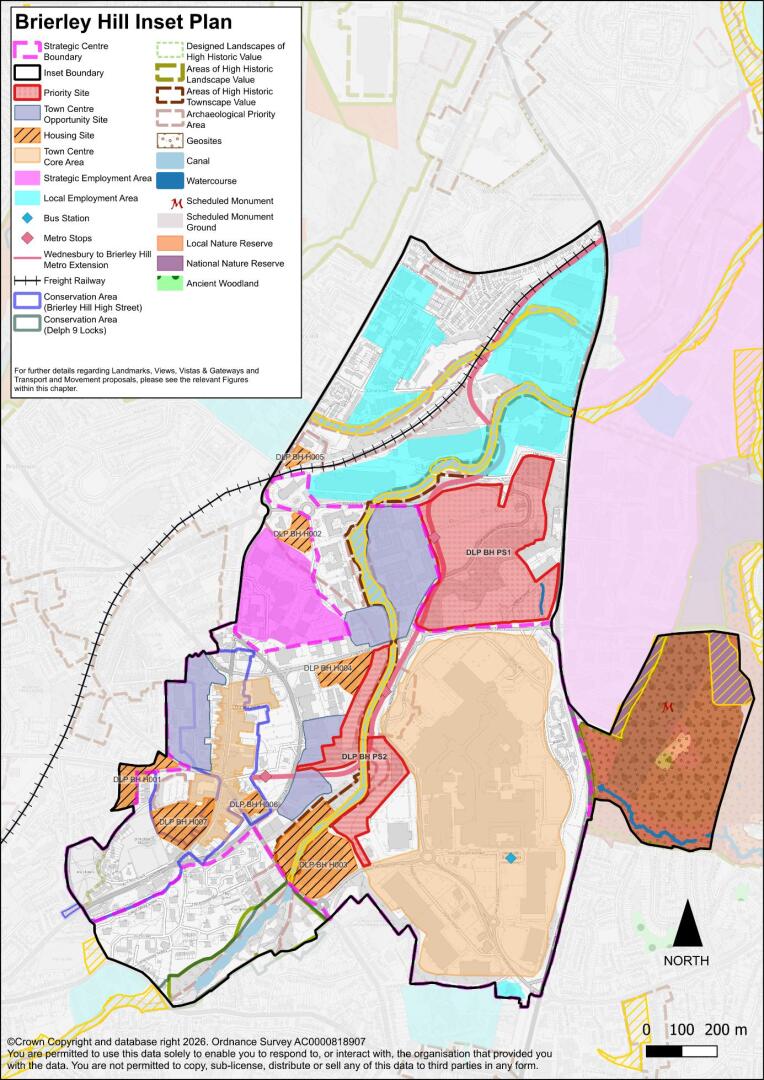
[1] Forest Research i-Tree Canopy cover guide
[2] Other uses within Use Class E (outside of E(e)) would not be supported and restrictive use conditions may be used where necessary
